Clogher
DatedEst. 4000–3000 BCE
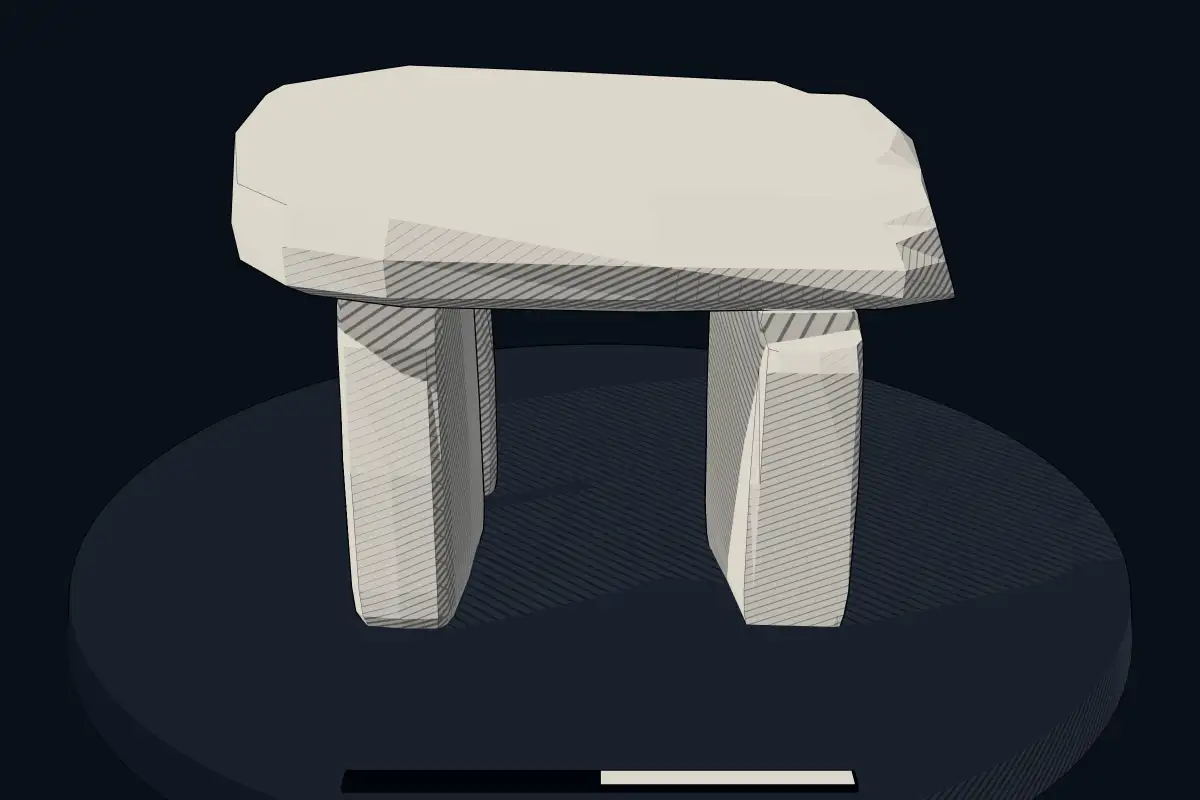
No licensed photograph yetWe have no photograph we may publish for this site, so the interpretive 3D view leads instead.
Overview
About this site
What the sources say
Das Townland Clogher liegt im Municipal District Ballymote–Tobercurry, im Süden des in drei solche Municipal Districts unterteilten County Sligo in Irland. Für einzelne Belange gehört es zur Civil Parish (weltlichen Gemeinde) Kilcolman, die aber keine Institutionen mehr hat.
Es liegt im Westen des Dorfes Monasteraden (Mainistir Réadáin) und grenzt nach Westen an das County Roscommon.
Der Name Clogher ist gälisch und bedeutet „steiniger Ort“. Daher kommt er mehrfach auf der Insel Irland vor.
Dieses Townland hat eine nennenswerte Streusiedlung und beherbergt zudem zwei archäologische Denkmäler, das Boulder Burial (auch Boulder Tomb) von Clogher (irisch An Clochar) und das Clogher Fort, nicht zu verwechseln mit dem Hillfort von Clogher im nordirischen County Tyrone.
Article in GermanRead on Wikipedia3 min readCC BY-SA 4.0
Where it sits in time
The site's dated range, placed against world reference points.
The scale is logarithmic: each step to the left is about ten times older than the last.
The full article
Clogher: the whole story
In briefSources for this section
Sources for this section
Clogher is a townland in the Municipal District Ballymote–Tobercurry, in the south of County Sligo, Ireland. It lies west of the village of Monasteraden and borders County Roscommon to the west. The townland contains the Clogher Boulder Burial, also called the Clogher Boulder Tomb and locally known as “The Giant Stone”.
The Clogher Boulder Burial stands on a dry platform in an otherwise wet landscape beside a forest plantation. Its large capstone measures about 1.8 m × 1.5 m × 0.7 m and rests on three supporting stones. Two supports are 0.35 m high, while the southern stone is 0.25 m high.
The monument is generally dated to 4000 BCE to 3000 BCE by typological estimate. Boulder Burials in Ireland are usually associated with the middle and late Bronze Age. They were not covered by cairns and often stood in groups of up to four. Pits beneath the rocks sometimes contained cremated remains. Similar structures at Achonry and in the Burren support the interpretation of Clogher as a Boulder Burial.
The name Clogher is Gaelic for “stony place” and appears more than once on the island of Ireland. Ireland has about 172 dolmens, a form of single-chamber portal tomb associated with the Neolithic farmers who built them more than five thousand years ago. Like other dolmens, they were built as tombs, and their capstones were once hidden.
Summary in EnglishSources for this section
Sources for this section
Clogher is a dolmen in County Sligo, Ireland. Wikidata describes it as: boulder burial in County Sligo, Ireland. A typological estimate: 4000 BCE to 3000 BCE. No English Wikipedia article exists for it; the full text below is the German article "Clogher Townland (County Sligo)", shown in the original language.
Boulder Tomb von ClogherSources for this section
Sources for this section
Dieses Großsteingrab ist lokal als „The Giant Stone“ bekannt, befindet sich auf einer trockenen Plattform in einer ansonsten feuchten Umgebung neben einer Forstplantage westlich des Dorfes
Der große Deckstein misst etwa 1,8 m × 1,5 m × 0,7 m und ruht auf drei Tragsteinen. Zwei Tragsteine haben eine Höhe von 0,35 m, während der Stein im Süden 0,25 m misst.
Seán Ó Nualláin erkennt Affinitäten dieser Struktur mit jenen Boulder Burials, die überwiegend in Südirland (über 50) vorkommen. Das Vorhandensein weiterer Boulder Burials im etwa 17 km entfernten Achonry sowie das Boulder Tomb im Burren, einem Townland im County Cavan, stützen die Interpretation.
Boulder Burials werden in die mittlere und späte Bronzezeit datiert. Die Denkmäler wurden nicht von Cairns bedeckt und standen oft in Gruppen von bis zu vier. Ein Merkmal von Boulder Burials sind Gruben unter dem Felsen, die eingeäscherte Überreste enthalten.
Südlich von Monasteraden liegt ein weiteres Großsteingrab, das Wedge Tomb von Tawnymucklagh.
How this page was madeSources for this section
Sources for this section
The summary at the top of this page was written by MiniMax-M3 (2026-11-08) from the cited Wikipedia article “Clogher Townland (County Sligo)”, translated from German. The numbers in it were checked automatically against the source text. The rest of the page is the article itself, the structured records and computed distances.
Tradition and region
About this kind of monument
Irish portal tombs
Ireland has about 172 dolmens, a form of single-chamber portal tomb, and they are among the best known monuments of the Neolithic farmers who built them more than five thousand years ago. Poulnabrone dolmen in the Burren, County Clare, is the best known: three portal stones carry a heavy horizontal capstone, and it stands on one of the highest points of an unusual limestone, or karst, landscape formed some 350 million years ago. It dates to the early Neolithic, with estimates between 3800 and 3200 BCE. The name Poll na Brón means "hole of the quernstone".
Brownshill Dolmen, three kilometres east of Carlow, is a very large portal tomb with three large uprights; its capstone is estimated to weigh 150 tonnes and is reputed to be the heaviest in Europe. It was built between 4000 and 3000 BCE and is a National Monument. These dolmens were built as tombs, and the capstones were once hidden under a mound of stones or earth that has since gone.
Folklore: at Proleek in County Louth, local legend says that the dolmen was carried there by the Scottish giant Para Buidhe Mór Mhac Seoidin, who challenged the hero Fionn mac Cumhaill to combat. Fionn poisoned a nearby river, Para drank from it, and the giant was buried at the site. A wedge-shaped gallery grave called the Giant's Grave lies about 90 metres to the south-east. The tale is traditional.
When visiting, look at how the portal stones frame the entrance and how the capstone slopes down towards the back, and note that some tombs stand close to roads.
Paraphrased from Wikipedia: Poulnabrone dolmen, Wikipedia: Brownshill Dolmen, Wikipedia: Proleek Dolmen, Wikipedia: Portal dolmen, Wikipedia: Dolmen · CC BY-SA 4.0
See it in 3D
An interpretive reconstruction of the monument, standing on the real ground at its exact point, under the sun for that place and season. Drag to look around it.
The reconstruction is ours, not a survey: it shows what a monument of this type looks like, at the size the record gives for this one.
Lore
Evidence & Lore
What the sources actually support — and, kept apart, what has been claimed.
What the evidence supports
Dates
Est. 4000–3000 BCEHow this date was established: Type comparisonTypical range for dolmens in Ireland; this site has not been dated itself. Irish portal tombs are dolmens and most date from the Late Neolithic period (4000-3000 BCE).Source for this date
Where it stands
Ireland
The pin marks the monument itself — its exact point.
- Coordinates
- 53°56′40″ N, 8°30′45″ WFor a GPS or map app: 53.94440, -8.51250
Access is as our sources describe it; we have not visited the site to check.
Nearby
The closest sites in the Atlas, by straight line.




Sources
Every record behind this page, with the link it came from.
2 sources behind this page
- 01Wikidata Q26807806wikidata.org
- 02Source for this dateen.wikipedia.org
Report a correctionWrong date, name, photograph or source? Tell us and it will be put right.
Around this place
The ten nearest sites, by compass
Credit
Text, licence and sources
Text from the Wikipedia article "Clogher Townland (County Sligo)" (German), licensed CC BY-SA 4.0; authors are listed in the page history. Reused under CC BY-SA 4.0. Read on Wikipedia · Edit history and authors