
MegalithFringe site
Carrowkeel Megalithic Cemetery
Also known asCarrowkeel
Datedc. 4000–2477 BCE*
Photo Enter · CC BY-SA 4.0Source file on Wikimedia Commons

Overview
About this site
What the sources say
Carrowkeel is a cluster of passage tombs in south County Sligo, Ireland. They were built in the 4th millennium BC, during the Neolithic era. The monuments are on the Bricklieve Hills (An Bricshliabh, 'the speckled hills'), overlooking Lough Arrow, and are sometimes called the Bricklieve tombs. They are named after the townland of Carrowkeel in which most of them are located. Nearby are the Caves of Kesh and Heapstown Cairn. The Carrowkeel tombs are protected National Monuments and are considered one of the "big four" passage tomb cemeteries in Ireland, along with Carrowmore, Brú na Bóinne and Loughcrew.
Read on Wikipedia6 min readCC BY-SA 4.0
Age sources
Sources disagree on the age of this site
Sources do not agree on how old this site is. Each claim is listed with where it comes from; the mainstream reading is marked.
Range across all claimsc. 4000–2477 BCE*
MeasuredWhat this badge means
A physical measurement of this site: a radiocarbon date, a tree-ring count, a luminescence date, or a record that can itself be dated.
- 2578–2477 BCERadiocarbon dating2 radiocarbon dates in the p3k14c database (Bird et al. 2022, Scientific Data 9:27 (p3k14c radiocarbon database)) between 4456 and 4499 BP; uncalibrated ages, sSource: p3k14c.org
- 4000–3001 BCEWikipedia: Carrowkeel Megalithic CemeterySource: en.wikipedia.org
- 3500–2900 BCEWikipedia: Carrowkeel Megalithic Cemetery (infobox)Source: en.wikipedia.org
- 4000 BCEWikidata inceptionSource: wikidata.org
Where it sits in time
The site's dated range, placed against world reference points.
The scale is logarithmic: each step to the left is about ten times older than the last.
The full article
Carrowkeel Megalithic Cemetery: the whole story
In briefSources for this section
Sources for this section
Carrowkeel is a cluster of passage tombs in south County Sligo, Ireland, built in the 4th millennium BC, during the Neolithic era. The monuments are on the Bricklieve Hills, overlooking Lough Arrow, and are sometimes called the Bricklieve tombs. They are named after the townland of Carrowkeel, in which most of them are located. Nearby are the Caves of Kesh and Heapstown Cairn. The tombs are protected National Monuments and are considered one of the big four passage tomb cemeteries in Ireland, along with Carrowmore, Brú na Bóinne and Loughcrew.
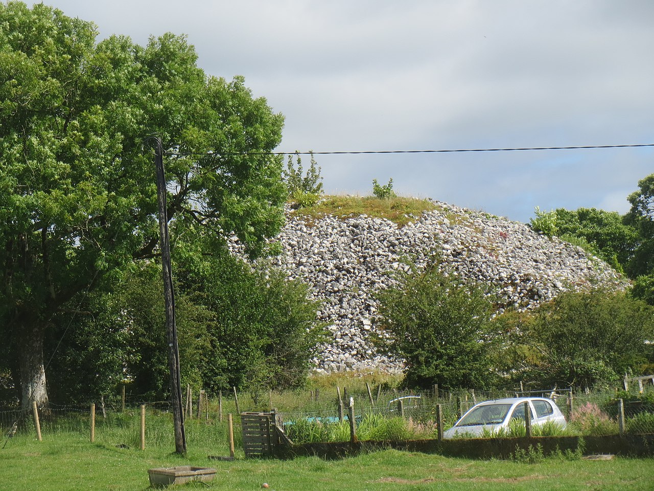
There are fourteen passage tombs in the central core of the complex, and some can be entered by crawling through a narrow passage. The entrances and passages are often oriented northwest, toward the area of Cúil Irra, Knocknarea and Carrowmore. Twelve more passage tombs are located within a radius of 6 km, sometimes at elevated locations such as the Keshcorran group. One outlier, the giant passage tomb Heapstown Cairn, is part of the legendary Moytura, a site of battles between the Tuatha Dé Danann and the demonic Fomorians.
The monuments were first excavated in 1911 by a team led by R.A.S. Macalister, with Robert Lloyd Praeger and Edmund Clarence Richard Armstrong. They found animal bones, cremated human remains, human bones, and tools and pottery. The crude pottery found in Irish passage tombs is called Carrowkeel Ware, after these monuments. Praeger later wrote of the first entry into one monument that everything lay as the last user had left it, with beads of stone, bone implements made from Red Deer antlers, and on small recesses in the wall flat stones bearing the calcinated bones of young children.
The original excavation mistakenly dated the monuments to the Bronze Age. New study of the bones, now curated in Cambridge, has shown that the sites were in use between c. 3,500 and 2,500 Cal. BC. Of 22 stable isotope samples, the majority indicated that the dead had grown up in a carboniferous limestone region, probably close to Carrowkeel. DNA genomes assembled from six individuals indicated ancestral origins in Anatolia.
The monuments are under threat from visitors climbing on them, scratching names on them and taking stones as keepsakes, and the tombs are in danger of collapse. Irish folklore holds that it is bad luck to damage or disrespect such tombs and that doing so could bring a curse. The Office of Public Works is preparing a program of works for their preservation and protection.
ArchaeologySources for this section
Sources for this section
The monuments at Carrowkeel were originally excavated in 1911 by a team led by R.A.S. Macalister, accompanied by Robert Lloyd Praeger and Edmund Clarence Richard Armstrong. These excavations led to an array of findings including animal bones, cremated human remains, human bones, and tools and pottery from the Neolithic Age. The particular type of crude pottery found in the Irish passage tombs is called Carrowkeel Ware, having first been recorded in the Carrowkeel Monuments. Some pottery has also been identified from the Bronze Age. Some of the artefacts recovered are stored in the National Museum of Ireland, but most of the bone assemblage was transported to Cambridge University, where Macalister's father, Alexander, was a Professor.
Praeger recorded an eerie account of the first entry into one of the Carrowkeel monuments in his 1937 memoir The Way That I Went:
I lit three candles and stood awhile, to let my eyes accustom themselves to the dim light. There was everything, just as the last Bronze Age man (sic) had left it, three to four thousand years before. A light brownish dust covered all... There beads of stone, bone implements made from Red Deer antlers, and many fragments of much decayed pottery. On little raised recesses in the wall were flat stones, on which reposed the calcinated bones of young children.
The bones curated in Cambridge at the Leverhulme Centre for Human Evolutionary Studies were researched by the Human Population Dynamics at Carrowkeel Project. The original excavation mistakenly dated the monuments as Bronze Age structures, but the new study has shown that the sites were in use between c. 3,500 and 2,500 Cal. BC. Of 22 stable isotope samples, the majority indicated that the dead had grown up in a carboniferous limestone region, probably close to Carrowkeel. The DNA genomes assembled from six individuals indicated ancestral origins in Anatolia, and greater affinity with the Mediterranean than the Danubian expansion of early farming in Europe.
Carrowkeel is set on high ground above Lough Arrow in the Bricklieve Mountains. There are fourteen passage tombs in the central core of the complex at Carrowkeel; some can be entered by crawling through a narrow passage. The entrances and passages of the monuments are often oriented northwest, towards the area of Cúil Irra, Knocknarea and Carrowmore. Twelve more passage tombs are located within a radius of 6 km, sometimes at elevated locations such as the Keshcorran group, or Suigh Lughaidh. One of these outliers is situated at the north end of Lough Arrow and NW Carrowkeel; the giant passage tomb, Heapstown Cairn. This is part of the legendary Moytura, a site of battles between the Tuatha Dé Danann, the ancient gods of Ireland, and the demonic Fomorians.
Conservation and modern historySources for this section
Sources for this section
The monuments are under threat from visitors climbing on them, scratching names on them, and taking stones as keepsakes. The tombs are in danger of collapse, and graffiti can damage ancient megalithic art which is not easy to see. There is evidence of recent treasure hunting at some tombs, apparently by people unaware that these "stone age sites are over 5,000 years old and pre-date the use of metals in Ireland". It is illegal to be in possession of metal detectors at historic monuments or to dig for objects. Irish folklore holds that it is bad luck to damage or disrespect such tombs and that doing so could bring a curse. The Office of Public Works is preparing a program of works for the preservation and protection of Carrowkeel.
How this page was madeSources for this section
Sources for this section
The summary at the top of this page was written by Claude Sonnet 5.5 (2026-11-06) from the cited Wikipedia article “Carrowkeel Megalithic Cemetery”. The numbers in it were checked automatically against the source text. The rest of the page is the article itself, the structured records and computed distances.
Tradition and region
About this kind of monument
Other prehistoric stone monuments
The Atlas uses the heading "other" for stone monuments that fit none of its other types, and the same article serves for underground chambers that have no regional article. The records are varied. Many are ziggurats, Egyptian temples and pyramids, and Maya and Andean sites, which are treated in their own articles. What remains is a scatter of single sites in many countries whose descriptions do not allow a closer classification.
Several of these are underground. A hypogeum is literally an "underground" temple or tomb, often with niches for cremated remains or loculi for buried remains. An early example is found at the Minoan Bronze Age site of Knossos on Crete, a beehive-shaped vault cut into soft rock. The Hypogeum of Ħal Saflieni in Paola, Malta, is the oldest example of a prehistoric hypogeum, with its earliest phase dated to 3600 to 3300 BCE. It is a complex of underground chambers, halls and passages covering about 500 square metres on three levels, partly carved to imitate temple architecture and containing extensive prehistoric art.
A rock-cut tomb is cut into an existing rock formation, usually a cliff or sloping rock face, and was a common burial form for the wealthy in several parts of the world. Famous clusters are in Egypt, Iran, Lycia in Turkey, Petra in Jordan and Sicily. Phrygian rock-cut tombs such as the Midas monument date to about 700 BCE, and Etruscan ones to about 500 BCE.
The general rule for these records is that the type tells you how a monument was made, not who made it or when. Dating is taken from the source for each site where a source gives one, and otherwise left as a broad range.
When visiting, read the site's own description first, since the Atlas can offer only a general frame.
Paraphrased from Wikipedia: Megalith, Wikipedia: Hypogeum, Wikipedia: Rock-cut tomb, Wikipedia: Stele · CC BY-SA 4.0
From the article
Dated moments in the story
- 1911
The monuments at Carrowkeel were originally excavated in 1911 by a team led by R.A.S.
Source - 1937
Praeger recorded an eerie account of the first entry into one of the Carrowkeel monuments in his 1937 memoir The Way That I Went: I lit three candles and stood awhile, to let my eyes accustom themselves to the dim light.
Source
Photographs
8 photographs, each with its author and licence
More photographs


Lore
Evidence & Lore
What the sources actually support — and, kept apart, what has been claimed.
What the evidence supports
Dates
2578–2477 BCEHow this date was established: Radiocarbon dating2 radiocarbon dates in the p3k14c database (Bird et al. 2022, Scientific Data 9:27 (p3k14c radiocarbon database)) between 4456 and 4499 BP; uncalibrated ages, shown as calendar years with the conventional BP + 1950 conversion.Source for this date
Measured facts
- Mainstream position
- Archaeological and scientific research places Carrowkeel's monuments in the Neolithic and dates their use to approximately 3500–2500 cal BC.Source: Mainstream position
- Location
- Bricklieve Hills, south County Sligo, IrelandSource: Location
- Central tombs
- Fourteen passage tombsSource: Central tombs
- Wider distribution
- Twelve more passage tombs within a radius of 6 kmSource: Wider distribution
- Protection
- National Monuments of IrelandSource: Protection
- Isotope samples
- Twenty-two stable isotope samplesSource: Isotope samples
- DNA sample
- Genomes assembled from six individualsSource: DNA sample
- Inception
- 4th millennium BCESource: Inception
- Heritage designation
- national monument of IrelandSource: Heritage designation
Alternative claims
Alternative claims about this site, kept in their own block and labelled with where they stand.
Heapstown Cairn is part of the legendary Moytura, where the Tuatha Dé Danann fought the Fomorians.
Where it stands
Ireland
The pin marks the monument itself — its exact point.
- Coordinates
- 54°03′12″ N, 8°22′40″ WFor a GPS or map app: 54.05333, -8.37778
Access is as our sources describe it; we have not visited the site to check.
Nearby
The closest sites in the Atlas, by straight line.
- Megalithic mound (tumulus with integral stones)Keshcorran Cairn3700–2900 BCE
 Heapstown Cairn3050–2950 BCE
 Carrickglass Dolmen4000–3000 BCE
- Court tomb (court cairn)Moytirra East Court Tomb3750–2900 BCE
 Drumanone4000–3000 BCE
- Wedge tombTawnymucklagh2500–2000 BCE
- DolmenClogher4000–3000 BCE
- Court tomb (court cairn)Carricknagat Megalithic Tombs3750–2900 BCE


Sources
Every record behind this page, with the link it came from.
4 sources behind this page
- 01Wikidata Q261318wikidata.org
- 02Fringe claim sourceen.wikipedia.org
- 03Wikipedia (en)en.wikipedia.org
- 04Source for this datep3k14c.org
Image files
- Carrowkeel Tomb Sommer 2025.jpgEnterCC BY-SA 4.0
- Two of the carrowkeel tombs.jpgJon SullivanPublic domain
- Bricklieve Mountains.jpgRob HursonCC BY-SA 4.0
- County Sligo - Carrowkeel Megalithic Cemetery - 20190706180256.jpgRob HursonCC BY-SA 4.0
- County Sligo - Carrowkeel Megalithic Cemetery - 20190706173845.jpgRob HursonCC BY-SA 4.0
- County Sligo - Carrowkeel Megalithic Cemetery - 20190820184441.jpgMóFionnagainCC BY-SA 4.0
- A view of the front entrance to one of the open sites at Carrowkeel.JPGShane FinanCC BY-SA 4.0
- Carrowkeel passage tomb remains, south Sligo.JPGShane FinanCC BY-SA 4.0
Report a correctionWrong date, name, photograph or source? Tell us and it will be put right.
Lore, kept apart
Legends and claims
These are stories and claims reported by the sources. They are not evidence, and they never stand in for the dating above.
- Tradition
There are fourteen passage tombs in the central core of the complex, and some can be entered by crawling through a narrow passage.
There are fourteen passage tombs in the central core of the complex, and some can be entered by crawling through a narrow passage. The entrances and passages are often oriented northwest, toward the area of Cúil Irra, Knocknarea and Carrowmore. Twelve more passage tombs are located within a radius of 6 km, sometimes at elevated locations such as the Keshcorran group. One outlier, the giant passage tomb Heapstown Cairn, is part of the legendary Moytura, a site of battles between the Tuatha Dé Danann and the demonic Fomorians.
Source - Tradition
The monuments are under threat from visitors climbing on them, scratching names on them and taking stones as keepsakes, and the tombs are in danger of collapse.
The monuments are under threat from visitors climbing on them, scratching names on them and taking stones as keepsakes, and the tombs are in danger of collapse. Irish folklore holds that it is bad luck to damage or disrespect such tombs and that doing so could bring a curse. The Office of Public Works is preparing a program of works for their preservation and protection.
Source - Tradition
The bones curated in Cambridge at the Leverhulme Centre for Human Evolutionary Studies were researched by the Human Population Dynamics at Carrowkeel Project.
The bones curated in Cambridge at the Leverhulme Centre for Human Evolutionary Studies were researched by the Human Population Dynamics at Carrowkeel Project. The original excavation mistakenly dated the monuments as Bronze Age structures, but the new study has shown that the sites were in use between c. 3,500 and 2,500 Cal. BC. Of 22 stable isotope samples, the majority indicated that the dead had grown up in a carboniferous limestone region, probably close to Carrowkeel. The DNA genomes assembled from six individuals indicated ancestral origins in Anatolia, and greater affinity with the Mediterranean than the Danubian expansion of early farming in Europe. Carrowkeel is set on high ground above Lough Arrow in the Bricklieve Mountains. There are fourteen passage tombs in the central core of the complex at Carrowkeel; some can be entered by crawling through a narrow passage. The entrances and passages of the monuments are often oriented northwest, towards the area of Cúil Irra, Knocknarea and Carrowmore. Twelve more passage tombs are located within a radius of 6 km, sometimes at elevated locations such as the Keshcorran group, or Suigh Lughaidh. One of these outliers is situated at the north end of Lough Arrow and NW Carrowkeel; the giant passage tomb, Heapstown Cairn. This is part of the legendary Moytura, a site of battles between the Tuatha Dé Danann, the ancient gods of Ireland, and the demonic Fomorians.
Source - Tradition
The monuments are under threat from visitors climbing on them, scratching names on them, and taking stones as keepsakes.
The monuments are under threat from visitors climbing on them, scratching names on them, and taking stones as keepsakes. The tombs are in danger of collapse, and graffiti can damage ancient megalithic art which is not easy to see. There is evidence of recent treasure hunting at some tombs, apparently by people unaware that these "stone age sites are over 5,000 years old and pre-date the use of metals in Ireland". It is illegal to be in possession of metal detectors at historic monuments or to dig for objects. Irish folklore holds that it is bad luck to damage or disrespect such tombs and that doing so could bring a curse. The Office of Public Works is preparing a program of works for the preservation and protection of Carrowkeel.
Source - Tested: not supported
Heapstown Cairn is part of the legendary Moytura, where the Tuatha Dé Danann fought the Fomorians.
Source
Around this place
The ten nearest sites, by compass
Credit
Text, licence and sources
Text from the Wikipedia article "Carrowkeel Megalithic Cemetery" (English), licensed CC BY-SA 4.0; authors are listed in the page history. Reused under CC BY-SA 4.0. Read on Wikipedia · Edit history and authors
- Wikipedia (English): Carrowkeel Megalithic CemeteryCC BY-SA 4.0
- Wikidata Q261318CC0
- Fringe claim sourceCC BY-SA 4.0