
Overview
About this site
What the sources say
KV44 is an ancient Egyptian tomb in the Valley of the Kings near Luxor, Egypt. It was discovered and excavated by Howard Carter in 1901 and was re-examined in 1991 by Donald P. Ryan. The single chamber accessed by a shaft contained three intact Twenty-second Dynasty burials; the remains of seven mummies from the original interment were found within the fill. The original cutting of the tomb is dated to the Eighteenth Dynasty.
Read on Wikipedia5 min readCC BY-SA 4.0
Where it sits in time
The site's dated range, placed against world reference points.
The scale is logarithmic: each step to the left is about ten times older than the last.
The full article
KV44: the whole story
In briefSources for this section
- Wikipedia (English): KV44CC BY-SA 4.0
Sources for this section
- Wikipedia (English): KV44CC BY-SA 4.0
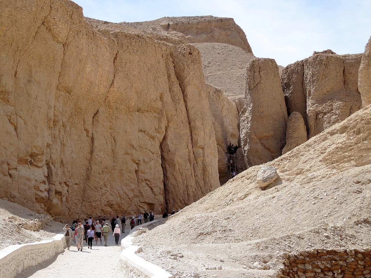
KV44 is an ancient Egyptian tomb in the Valley of the Kings near Luxor, Egypt. It lies near KV28 and next to KV45, in a small side wadi that runs east from the main valley. The tomb consists of a shaft 5.5 metres (18 ft) deep ending in a single chamber, whose doorway was securely, if roughly, sealed. The original cutting is dated to the Eighteenth Dynasty.
Howard Carter opened it on 26 January 1901, after two days of excavation. The chamber was partly filled with water-washed earth. On top of the fill sat three wooden coffins, draped in floral wreaths, which held three intact Twenty-second Dynasty burials. One contained the mummy of Iuf'a, another a chantress identified by Porter and Moss as Keramama, and the third the mummy of Tentkeresherit, fitted with red leather mummy braces stamped with the cartouche of Osorkon I.
These were not the original occupants. Carter noted that the room was a fifth full of debris amongst which were remains of earlier mummies without either coffins or funeral furniture. Several bee nests on the ceiling showed that the tomb had stood open for some time. In 1991 the Pacific Lutheran University Valley of the Kings Project, headed by Donald P. Ryan, re-investigated it and recovered the remains of seven individuals, two of them young women and three children, including one two year-old. Small finds included pottery fragments and a blue cylinder bead. The project resumed in 2005 and found that water had entered several tombs, likely during the 1994 flood events.
The intended occupants are not known. Elizabeth Thomas proposed a tomb for Anen, the brother of Tiye, the Great Royal Wife of Amenhotep III, based on the clustering of late Eighteenth Dynasty tombs here. However, Ryan's excavations found no material later than the middle of the Eighteenth Dynasty, so there is no archaeological evidence for the burial of Anen in KV44.
SettingSources for this section
- Wikipedia (English): KV44CC BY-SA 4.0
Sources for this section
- Wikipedia (English): KV44CC BY-SA 4.0
KV44 is situated near KV28 and next to KV45 in a small side wadi that runs east from the main valley. The location of the tomb was already known in Western Thebes some time before late January 1901 and was opened by Howard Carter on 26 January 1901 after two days of excavation. The tomb consists of a shaft 5.5 metres (18 ft) deep ending in a single chamber. The doorway to the room was securely, if roughly, sealed.
ContentsSources for this section
- Wikipedia (English): KV44CC BY-SA 4.0
Sources for this section
- Wikipedia (English): KV44CC BY-SA 4.0
The chamber was partly filled with water-washed earth. On top of this fill sat three wooden coffins placed beside each other against one wall and draped in floral wreaths. Nearest the wall was a black-painted wooden coffin with yellow decoration and red text; this coffin contained the well wrapped mummy of Iuf'a. Beside this was another coffin, also painted black with yellow designs but with inlaid eyes housing a cartonnage coffin covered in resin; inside was a mummy identifiable only as a chantress by the legible portion of the inscription. However, Porter and Moss identify her as Keramama. The third coffin was of rough wood but contained a beautifully decorated cartonnage coffin; inside was the well wrapped mummy of Tentkeresherit, fitted with red leather mummy braces stamped at the ends with the cartouche of Osorkon I. Percy Newberry identified the floral wreaths as being composed of Mimusops, Mimosa nilotica, Centaurea depressa, and Nymphaea cerulea.
These three burials were not the original occupants however, as Carter noted that the room was a fifth full of debris "amongst which were remains of earlier mummies without either coffins or funeral furniture". The tomb had evidently stood open for some time in the past as several bee nests were seen on the ceiling.
ArchaeologySources for this section
- Wikipedia (English): KV44CC BY-SA 4.0
Sources for this section
- Wikipedia (English): KV44CC BY-SA 4.0
In 1991 the tomb was re-investigated by the Pacific Lutheran University Valley of the Kings Project headed by Donald P. Ryan. Other than removing the three coffins to Cairo, Carter had undertaken little work in the tomb. Careful excavation of the fill recovered the remains of seven individuals; two were young women, and three were children including one two year-old. The foot board of a child's coffin was also found along with an uninscribed piece of a canopic jar. Small finds included pottery fragments and a blue cylinder bead.
The project resumed in 2005, and found that water had penetrated several of the tombs under study, likely during the 1994 flood events. All artefacts from KV44 and KV45, barring pottery and human remains, were moved to KV21 for protection from further flooding.
Intended occupantsSources for this section
- Wikipedia (English): KV44CC BY-SA 4.0
Sources for this section
- Wikipedia (English): KV44CC BY-SA 4.0
The intended occupants of KV44 are not known. Elizabeth Thomas proposed that this was a tomb for Anen, the brother of Tiye, the Great Royal Wife of Amenhotep III. This theory was proposed based on the clustering of late Eighteenth Dynasty tombs in this area and the fact that Anen was not buried in his known intended tomb TT120. However, Ryan's excavations found no material in the tomb to date later than the middle of the Eighteenth Dynasty, and as such there is no archaeological evidence for the burial of Anen within KV44.
How this page was madeSources for this section
- Wikipedia (English): KV44CC BY-SA 4.0
Sources for this section
- Wikipedia (English): KV44CC BY-SA 4.0
The summary at the top of this page was written by Claude Sonnet 5.5 (2026-11-06) from the cited Wikipedia article “KV44”. The numbers in it were checked automatically against the source text. The rest of the page is the article itself, the structured records and computed distances.
Tradition and region
About this kind of monument
Rock-cut tombs of Egypt
Egypt has some of the best-known rock-cut tombs in the world. In the Valley of the Kings, on the west bank of the Nile opposite Thebes, tombs were excavated for pharaohs and powerful nobles of the New Kingdom, for a period of nearly 500 years from the Eighteenth to the Twentieth Dynasty. The valley has two main sections, the East Valley where most royal tombs lie and the West Valley, known as the Valley of the Monkeys, and it is known to contain 65 tombs and chambers. It gained great attention after the discovery of the tomb of Tutankhamun in 1922, and became a UNESCO World Heritage Site in 1979 with the rest of the Theban Necropolis.
Much earlier, Beni Hasan in Middle Egypt is an ancient funerary site cut into the limestone cliffs on the east bank of the Nile about 20 kilometres south of Minya. In the Middle Kingdom it was the principal cemetery of the sixteenth nome of Upper Egypt, the Oryx nome, and its monumental tombs were cut roughly halfway up the cliff, overlooking the valley. Rock-cut tombs are also found at Deir el-Medina, between the Valley of the Kings and the Valley of the Queens.
The mastaba is a different tradition: a flat-roofed rectangular tomb with sloping sides, built of mudbrick or limestone, which marked the burial sites of eminent Egyptians in the Early Dynastic Period and Old Kingdom. The mastaba was built above ground and the rock-cut tomb into the cliff.
Egyptian tombs are among the best dated monuments in the Atlas, because the dynasty or reign of the king or noble who owned them is known.
When visiting, remember that access to many tombs is limited.
Paraphrased from Wikipedia: Valley of the Kings, Wikipedia: Beni Hasan, Wikipedia: Rock-cut tomb, Wikipedia: Mastaba · CC BY-SA 4.0
From the article
Dated moments in the story
- 1901
It was discovered and excavated by Howard Carter in 1901 and was re-examined in 1991 by Donald P.
Source - 1901
The location of the tomb was already known in Western Thebes some time before late January 1901 and was opened by Howard Carter on 26 January 1901 after two days of excavation.
Source - 1991
In 1991 the tomb was re-investigated by the Pacific Lutheran University Valley of the Kings Project headed by Donald P.
Source - 2005
The project resumed in 2005, and found that water had penetrated several of the tombs under study, likely during the 1994 flood events.
Source
Photographs
1 photograph, each with its author and licence
Lore
Evidence & Lore
What the sources actually support — and, kept apart, what has been claimed.
What the evidence supports
Dates
Est. 3600–2500 BCEHow this date was established: Type comparisonTypological estimate, not a date for this site: a hypogeum in North Africa is normally dated between 3600 BCE and 2500 BCE (Atlas typological table).Source for this date
Measured facts
- Location
- Valley of the Kings near Luxor, EgyptSource: Location
- Discovery and excavation
- Howard Carter, 1901Source: Discovery and excavation
- Re-examination
- Donald P. Ryan, 1991Source: Re-examination
- Chambers
- One chamber accessed by a shaftSource: Chambers
- Burials
- Three intact Twenty-second Dynasty burialsSource: Burials
- Original interment
- Seven mummy remains found in the fillSource: Original interment
- Culture
- Ancient EgyptSource: Culture
- Length
- 6 metreSource: Length
Where it stands
Egypt
The pin marks the monument itself — its exact point.
- Coordinates
- 25°45′00″ N, 32°36′51″ EFor a GPS or map app: 25.75000, 32.61430
Access is as our sources describe it; we have not visited the site to check.
Nearby
The closest sites in the Atlas, by straight line.





Sources
Every record behind this page, with the link it came from.
2 sources behind this page
- 01Wikidata Q1661091wikidata.org
- 02Wikipedia (en)en.wikipedia.org
Image files
- KV44.jpgR.F.MorganCC BY-SA 3.0
Report a correctionWrong date, name, photograph or source? Tell us and it will be put right.
Around this place
The ten nearest sites, by compass
Credit
Text, licence and sources
Text from the Wikipedia article "KV44" (English), licensed CC BY-SA 4.0; authors are listed in the page history. Reused under CC BY-SA 4.0. Read on Wikipedia · Edit history and authors
- Wikipedia (English): KV44CC BY-SA 4.0
- Wikidata Q1661091CC0