
Megalithic mound (tumulus with integral stones)
Shrum Mound
Datedc. 800 BCE–100 CE
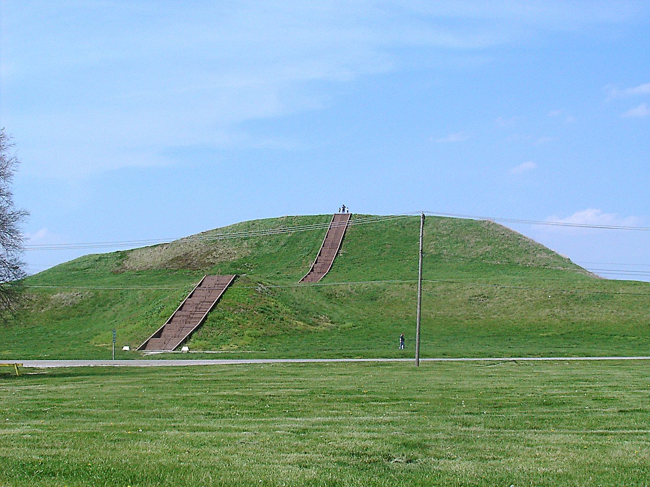
Photo Niagara66 · CC BY-SA 4.0Source file on Wikimedia Commons
Overview
About this site
Overview
Shrum Mound is a Native American conical burial mound in Campbell Memorial Park in Columbus, Ohio, built by people of the Adena culture roughly 2,000 years ago. It is one of the last surviving ancient mounds within the city of Columbus.
It was entered on the National Register of Historic Places on November 10, 1970, under the official listing name Campbell Mound. The mound has never been archaeologically excavated, and its precise contents remain unknown.
Read on Wikipedia4 min readCC BY-SA 4.0
Age sources
How old this site is, and who says so.
Range across all claimsc. 800 BCE–100 CE
UnknownWhat this badge means
No date is known for this site yet.
- 800 BCE–100 CEWikipedia: Shrum Mound (infobox)Source: en.wikipedia.org
- 26 CEWikipedia: Shrum MoundSource: en.wikipedia.org
Article
Shrum Mound
The mound is bordered by an active quarry lake known locally as the McKinley Avenue Quarry, operated by the Columbus Division of Water.
DescriptionSources for this section
- Wikipedia (English): Shrum MoundCC BY-SA 4.0
Sources for this section
- Wikipedia (English): Shrum MoundCC BY-SA 4.0
Shrum Mound stands on a high bluff on the west side of the Scioto River. It measures approximately 20 feet (6 m) in height and about 100 feet (30 m) in diameter.
The mound is bordered by an active quarry lake known locally as the McKinley Avenue Quarry, operated by the Columbus Division of Water. Limestone was extracted there from the late 19th century into the early 20th century, after which the exhausted quarry filled with water. Beginning in the 1970s the city used the flooded quarry as a repository for residual byproducts of municipal water treatment. As of 2026 the city has undertaken a large dredging project there, citing the site's limited remaining capacity.
Access to the summit has changed over time. The photograph archive of the Ohio History Connection, spanning 1929 to 1963, describes a set of formal steps leading to the top. More recent visitor accounts instead describe two unpaved dirt paths to the summit, a gentler route from the park's entry gate and a steeper, more direct route on the western side.
ArchaeologySources for this section
- Wikipedia (English): Shrum MoundCC BY-SA 4.0
Sources for this section
- Wikipedia (English): Shrum MoundCC BY-SA 4.0
The mound has never been archaeologically excavated, and its precise contents remain unknown. An archaeologist of the Ohio History Connection, Neil Thompson, has stated that the mound likely still contains numerous interments.
DatingSources for this section
- Wikipedia (English): Shrum MoundCC BY-SA 4.0
Sources for this section
- Wikipedia (English): Shrum MoundCC BY-SA 4.0
Sources vary somewhat on the precise dating of the Adena culture. The visitor materials and on-site historical markers of the Ohio History Connection place it at roughly 800 BC to AD 100, while its Ohio Memory photograph archive and the Ancient Ohio Trail project give a range of roughly 500 BC to AD 200. Both ranges fall within the standard scholarly window for the Adena. The National Register entry cites information potential as the applicable significance criterion and lists prehistory as its area of significance, with an estimated period of significance spanning roughly 499 BC to AD 499.
HistorySources for this section
- Wikipedia (English): Shrum MoundCC BY-SA 4.0
Sources for this section
- Wikipedia (English): Shrum MoundCC BY-SA 4.0
The mound is named for its donors, the Shrum family, on whose farmland it once stood. Minnie R. Shrum, an educator, deeded the site to the Ohio Historical Society (now the Ohio History Connection) in 1928. An earlier published account instead credited the donation to Governor James E. Campbell rather than the Shrum family; that claim is not adopted here.
The surrounding park, Campbell Memorial Park, is named for James E. Campbell, Governor of Ohio from 1890 to 1892, who later served as president of the Ohio Archaeological and Historical Society, the predecessor of the Ohio Historical Society, from 1913 to 1924. His daughter, Jessie Campbell Coons, named the park in his memory in 1929. The Ohio Archaeological and Historical Society erected an on-site memorial marker the same year.
ConservationSources for this section
- Wikipedia (English): Shrum MoundCC BY-SA 4.0
Sources for this section
- Wikipedia (English): Shrum MoundCC BY-SA 4.0
In the summer of 2015, the Ohio History Connection removed approximately 18 trees that had grown on top of the mound, citing concerns that a strong storm could topple a tree and damage the burial site. In January 2026 it publicly asked visitors to stop using the mound as a sledding hill, emphasizing its status as a burial site. Thompson described the mound as sacred ground for that reason.
VisitingSources for this section
- Wikipedia (English): Shrum MoundCC BY-SA 4.0
Sources for this section
- Wikipedia (English): Shrum MoundCC BY-SA 4.0
Shrum Mound is located at 3141 McKinley Avenue, about half a mile south of Trabue Road, in Columbus's West Scioto neighborhood. The site is managed by the Ohio History Connection and is open to visitors free of charge, with a typical visit lasting about 30 minutes.
ContextSources for this section
- Wikipedia (English): Shrum MoundCC BY-SA 4.0
Sources for this section
- Wikipedia (English): Shrum MoundCC BY-SA 4.0
Eastern North America has many earthen mounds, built over several thousand years by Native American peoples. They are not megaliths but earthworks of piled soil, and they served as graves, platforms and symbols. The Adena culture of the Early Woodland period, from 500 BCE to 100 CE and centred on Ohio, built burial mounds and shared a ceremonial system.
Tradition and region
About this kind of monument
Native American earthen mounds
Eastern North America has many earthen mounds, built over several thousand years by Native American peoples. They are not megaliths, but earthworks of piled soil, and they served as graves, platforms and symbols. The Adena culture of the Early Woodland period, from 500 BCE to 100 CE and centred on Ohio, built burial mounds and shared a ceremonial system. The Hopewell tradition, a network of cultures from 100 BCE to 500 CE, exchanged goods from Lake Ontario to Florida and raised burial mounds and geometric enclosures. The Mississippian period, from the end of the tenth century to the sixteenth, brought maize farming, large towns, and platform mounds on which temples and chiefs' houses stood.
The grandest is Monks Mound at Cahokia, Illinois, the largest pre-Columbian earthwork in the Americas. Its construction began between 900 and 955 CE; it is about 30 metres high and 291 metres long including the access ramp, with a base about the size of the Great Pyramid of Giza. Effigy mounds are mounds shaped as animals or symbols; the effigy mound builders are mainly associated with 550 to 1200 CE, though radiocarbon dating puts the origin of some as far back as 320 BCE. The Great Serpent Mound in Ohio, 411 metres long and about 1.2 metres high, is the largest serpent effigy known, surveyed in 1848 by Squier and Davis.
Mounds are dated by radiocarbon dating of charcoal and by pottery; many were levelled by farming and by antiquarian digging. Nineteenth-century theories of a vanished race of Mound Builders have no support: the mounds were raised by Native American peoples.
When visiting, remember that many mounds are sacred places. Look for platform tops, the flat summits of mounds that held buildings, and for the ramps and plazas around them.
Paraphrased from Wikipedia: Adena culture, Wikipedia: Hopewell tradition, Wikipedia: Mississippian culture, Wikipedia: Serpent Mound, Wikipedia: Monks Mound, Wikipedia: Effigy mound, Wikipedia: Poverty Point, Wikipedia: Mound Builders · CC BY-SA 4.0
From the article
Dated moments in the story
- 800 BCE
Sources vary somewhat on the precise dating of the culture: Ohio History Connection's own visitor materials and the on-site historical markers place it at roughly 800 BC to AD 100, while Ohio History Connection's separate Ohio Memory photograph archive and the Ancient Ohio Trail project instead give a range of...
Source - 1890
Campbell, Governor of Ohio from 1890 to 1892, who later served as president of the Ohio Archaeological and Historical Society (the predecessor of the Ohio Historical Society) from 1913 to 1924. His daughter, Jessie Campbell Coons, named the park in his memory in 1929. The Ohio Archaeological and Historical Society...
Source - 1928
Shrum, an educator, deeded the site to the Ohio Historical Society (now the Ohio History Connection) in 1928. This attribution is corroborated independently by Ohio History Connection's own visitor materials, its Ohio Memory photograph archive, and both on-site historical markers.
Source - 1929
Ohio History Connection's own photograph archive, spanning 1929 to 1963, describes a set of formal steps leading to the top.
Source - 1970
The mound was entered on the National Register of Historic Places on November 10, 1970, under the official listing name "Campbell Mound."
Source - 2026
Beginning in the 1970s the city used the flooded quarry as a repository for residual byproducts of municipal water treatment; as of 2026 the city has undertaken a large dredging project there, citing the site's limited remaining capacity.
Source - 2026
In January 2026, the Ohio History Connection publicly asked visitors to stop using the mound as a sledding hill, emphasizing its status as a burial site.
Source
See it in 3D
An interpretive reconstruction of the monument, standing on the real ground at its exact point, under the sun for that place and season. Drag to look around it.

The reconstruction is ours, not a survey: it shows what a monument of this type looks like, at the size the record gives for this one.
Photographs
6 photographs, each with its author and licence
More photographs
Where it stands
United States
The pin marks the monument itself — its exact point.
- Coordinates
- 39°59′24″ N, 83°04′50″ WFor a GPS or map app: 39.99001, -83.08057
Access is as our sources describe it; we have not visited the site to check.
Nearby
The closest sites in the Atlas, by straight line.




Sources
Every record behind this page, with the link it came from.
2 sources behind this page
- 01Wikidata Q28403189wikidata.org
- 02Wikipedia: Shrum Mounden.wikipedia.org
Image files
- Shrum Mound 1 70000490.jpgNiagara66CC BY-SA 4.0
- Shrum Mound 2 70000490.jpgNiagara66CC BY-SA 4.0
- Shrum Mound aerial 2.jpgKevin PayraviCC BY-SA 4.0
- Shrum Mound entrance.jpgKevin PayraviCC BY-SA 4.0
- Shrum Mound 01.jpg"Photographs copyright of Choosy Traveler. May be re-blogged under the Creative Commons Attribution license, with accreditation and link to this page."CC BY 4.0
- Shrum Mound 03.jpg"Photographs copyright of Choosy Traveler. May be re-blogged under the Creative Commons Attribution license, with accreditation and link to this page."CC BY 4.0
Report a correctionWrong date, name, photograph or source? Tell us and it will be put right.
Around this place
The ten nearest sites, by compass
Credit
Text, licence and sources
Adapted from the Wikipedia article "Shrum Mound" (English), licensed CC BY-SA 4.0; authors are listed in the page history. Reused under CC BY-SA 4.0. Read on Wikipedia · Edit history and authors
- Wikipedia (English): Shrum MoundCC BY-SA 4.0
- Wikidata Q28403189CC0