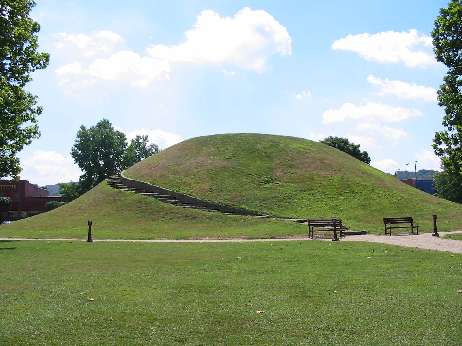
Megalithic mound (tumulus with integral stones)
Criel Mound
Also known asSouth Charleston Mound
Datedc. 250–150 BCE
Photo David G. Simpson · Public domainSource file on Wikimedia Commons
Overview
About this site
What the sources say
The Criel Mound, also known as the South Charleston Mound, is a Native American burial mound located in South Charleston, West Virginia. It is one of the few surviving mounds of the Kanawha Valley Mounds that were probably built in the Woodland period after 500 B.C. The mound was built by the Adena culture, probably around 250–150 BC, and lay equidistant between two “sacred circles”, earthwork enclosures each 556 feet (169 m) in diameter. It was originally 33 feet (10 m) high and 173 feet (53 m) in diameter at the base, making it the second-largest such burial mound in the state of West Virginia. (The Grave Creek Mound in Moundsville is the largest.) This archaeological site is listed on the National Register of Historic Places.
Read on Wikipedia4 min readCC BY-SA 4.0
The full article
Criel Mound: the whole story
In briefSources for this section
- Wikipedia (English): Criel MoundCC BY-SA 4.0
Sources for this section
- Wikipedia (English): Criel MoundCC BY-SA 4.0
Criel Mound, also known as the South Charleston Mound, is a Native American burial mound in South Charleston, West Virginia. Built by the Adena culture, probably around 250–150 BC, it is among the few surviving mounds of the Kanawha Valley Mounds and is thought to date from the Woodland period after 500 B.C.
The mound was originally conical, 33 feet (10 m) high and 173 feet (53 m) in diameter at the base. It was the second-largest burial mound of its kind in West Virginia, after Grave Creek Mound. In 1840, residents leveled its top to erect a judges' stand while holding horse races around the base.
Excavated in 1883–84 by Professor Cyrus Thomas of the Smithsonian Institution under Col. P.W. Norris, the mound contained thirteen skeletons. Eleven lay at the base, where a large central skeleton was surrounded by ten others in a spoke-like pattern. Arrowheads, lanceheads, shell and pottery fragments, a fish-dart, and a sheet of hammered native copper were also found.
Criel Mound is now the centerpiece of Staunton Park, a small municipal park maintained by the city of South Charleston. It hosts community activities including arts and crafts fairs, revivals, memorial services, sunrise services, and town carnivals. It is listed on the National Register of Historic Places. Earthen monuments of this kind in Eastern North America served as graves, platforms, and symbols.
History and datingSources for this section
- Wikipedia (English): Criel MoundCC BY-SA 4.0
Sources for this section
- Wikipedia (English): Criel MoundCC BY-SA 4.0
The mound was originally conical in shape. Residents of the area leveled the top in 1840 to erect a judges' stand, as they ran horse races around the base of the mound at the time.
The Criel Mound was excavated in 1883–84 under the auspices of the US Bureau of Ethnology and the supervision of Col. P.W. Norris. The excavation was performed by Professor Cyrus Thomas of the Smithsonian Institution. Inside the mound, Professor Thomas found thirteen skeletons: two near the top of the mound, and eleven at the base. The skeletons at the base consisted of a single very large but badly decayed skeleton at the center, a "once most powerful man" which according to A.R. Sines, who assisted Col. Norris in the excavation, measured "Six feet, 8 3/4 inches" (205 cm) from head to heel (the Smithsonian nomination form added "but the extreme height indicated might have been an exaggeration created by earth pressing down on the burial"). This skeleton was surrounded by ten other skeletons arranged in a spoke-like pattern, with their feet pointing toward the central skeleton. The skeletons at the base had been wrapped in elm bark and were lying on a floor of white ash and bark. Several artifacts were found buried with the skeletons, including arrowheads, lanceheads, and shell and pottery fragments. The central skeleton was accompanied by a fish-dart, a lance-head, and a sheet of hammered native copper near the head. Holes found at the base of the mound suggest that the bodies at the base had been enclosed in a wooden vault.
Kanawha Valley Mounds
The Criel Mound is part of the second-largest known concentration of Adena mounds and circular enclosures which Cyrus Thomas called the "Kanawha Valley Mounds". This area extends for eight miles (13 km) along the upper terraces of the Kanawha River floodplain, in the vicinity of present-day Charleston. In 1894, Cyrus Thomas reported 50 mounds in this area, ranging from 3’ to 35’ in height and from 35’ to 200’ in diameter. He also reported finding eight to ten circular earthworks, enclosing from 1 to 30 acres (120,000 m2). Stone mounds dotted the bluffs above the floodplain.
While many of the original Adena mounds were destroyed during later development of the area, a few remain. The Wilson Mound is in a private cemetery in South Charleston. A recreation of the original Shawnee Reservation Mound exists in Institute, West Virginia.
Staunton Park
Today, the Criel Mound is the centerpiece of Staunton Park, a small municipal park maintained by the city of South Charleston. It is a gathering place for community activities, such as arts and crafts fairs, revivals, memorial services, sunrise services, and town carnivals.
How this page was madeSources for this section
- Wikipedia (English): Criel MoundCC BY-SA 4.0
Sources for this section
- Wikipedia (English): Criel MoundCC BY-SA 4.0
The summary at the top of this page was written by MiniMax-M3 (2026-11-07) from the cited Wikipedia article “Criel Mound”. The numbers in it were checked automatically against the source text. The rest of the page is the article itself, the structured records and computed distances.
Tradition and region
About this kind of monument
Native American earthen mounds
Eastern North America has many earthen mounds, built over several thousand years by Native American peoples. They are not megaliths, but earthworks of piled soil, and they served as graves, platforms and symbols. The Adena culture of the Early Woodland period, from 500 BCE to 100 CE and centred on Ohio, built burial mounds and shared a ceremonial system. The Hopewell tradition, a network of cultures from 100 BCE to 500 CE, exchanged goods from Lake Ontario to Florida and raised burial mounds and geometric enclosures. The Mississippian period, from the end of the tenth century to the sixteenth, brought maize farming, large towns, and platform mounds on which temples and chiefs' houses stood.
The grandest is Monks Mound at Cahokia, Illinois, the largest pre-Columbian earthwork in the Americas. Its construction began between 900 and 955 CE; it is about 30 metres high and 291 metres long including the access ramp, with a base about the size of the Great Pyramid of Giza. Effigy mounds are mounds shaped as animals or symbols; the effigy mound builders are mainly associated with 550 to 1200 CE, though radiocarbon dating puts the origin of some as far back as 320 BCE. The Great Serpent Mound in Ohio, 411 metres long and about 1.2 metres high, is the largest serpent effigy known, surveyed in 1848 by Squier and Davis.
Mounds are dated by radiocarbon dating of charcoal and by pottery; many were levelled by farming and by antiquarian digging. Nineteenth-century theories of a vanished race of Mound Builders have no support: the mounds were raised by Native American peoples.
When visiting, remember that many mounds are sacred places. Look for platform tops, the flat summits of mounds that held buildings, and for the ramps and plazas around them.
Paraphrased from Wikipedia: Adena culture, Wikipedia: Hopewell tradition, Wikipedia: Mississippian culture, Wikipedia: Serpent Mound, Wikipedia: Monks Mound, Wikipedia: Effigy mound, Wikipedia: Poverty Point, Wikipedia: Mound Builders · CC BY-SA 4.0
From the article
Dated moments in the story
- 500 BCE
It is one of the few surviving mounds of the Kanawha Valley Mounds that were probably built in the Woodland period after 500 B.C.
Source - 150 BCE
The mound was built by the Adena culture, probably around 250–150 BC, and lay equidistant between two “sacred circles”, earthwork enclosures each 556 feet (169 m) in diameter.
Source - 1840
Residents of the area leveled the top in 1840 to erect a judges' stand, as they ran horse races around the base of the mound at the time.
Source - 1883
The Criel Mound was excavated in 1883–84 under the auspices of the US Bureau of Ethnology and the supervision of Col.
Source - 1894
In 1894, Cyrus Thomas reported 50 mounds in this area, ranging from 3’ to 35’ in height and from 35’ to 200’ in diameter.
Source
See it in 3D
An interpretive reconstruction of the monument, standing on the real ground at its exact point, under the sun for that place and season. Drag to look around it.

The reconstruction is ours, not a survey: it shows what a monument of this type looks like, at the size the record gives for this one.
Photographs
3 photographs, each with its author and licence
More photographs
Where it stands
United States
The pin marks the monument itself — its exact point.
- Coordinates
- 38°22′07″ N, 81°41′48″ WFor a GPS or map app: 38.36861, -81.69667
Access is as our sources describe it; we have not visited the site to check.
Nearby
The closest sites in the Atlas, by straight line.




Sources
Every record behind this page, with the link it came from.
2 sources behind this page
- 01Wikidata Q5185117wikidata.org
- 02Wikipedia: Criel Mounden.wikipedia.org
Image files
- Criel Mound.jpgDavid G. SimpsonPublic domain
- The Mound (35191501016).jpgJosh Stapler from Charleston, United StatesCC BY 2.0
- Criel Mound South Charleston.jpgHarper1040CC BY-SA 4.0
Report a correctionWrong date, name, photograph or source? Tell us and it will be put right.
Around this place
The ten nearest sites, by compass
Credit
Text, licence and sources
Text from the Wikipedia article "Criel Mound" (English), licensed CC BY-SA 4.0; authors are listed in the page history. Reused under CC BY-SA 4.0. Read on Wikipedia · Edit history and authors
- Wikipedia (English): Criel MoundCC BY-SA 4.0
- Wikidata Q5185117CC0