
Megalithic mound (tumulus with integral stones)
Round Hill
Also known asArcheological Site 15 Ma 24 · Round Hill, Kentucky · Round Hill, KY
DatedEst. 4000–1200 BCE
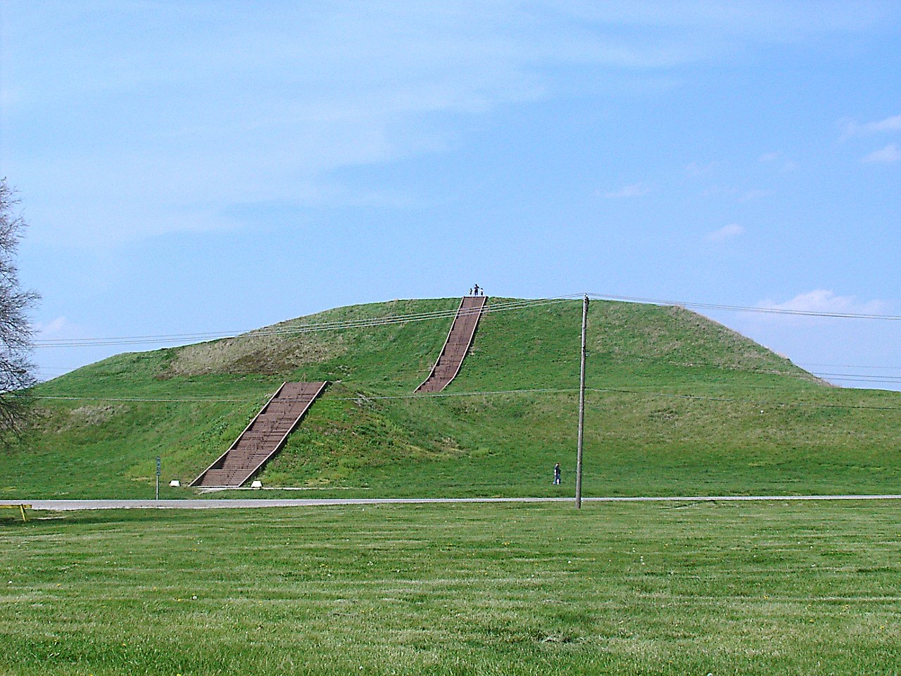
Photo Aramgar · CC BY-SA 3.0Source file on Wikimedia Commons
Overview
About this site
What the sources say
Round Hill is an unincorporated community in Madison County, Kentucky, United States. It lies 10 miles southwest of Richmond on Kentucky Route 595. Round Hill is part of the Richmond–Berea Micropolitan Statistical Area.
A burial mound attributed by the National Register of Historic Places to the Adena culture is the central feature of the village. The ovoid earthwork has a base of roughly 150 by 90 feet and a height of 25 feet. Unsystematic excavations in the early twentieth century by local residents produced flint tools and human remains. The mound stands on private property but is visible from the road.
Read on Wikipedia2 min readCC BY-SA 4.0
Where it sits in time
The site's dated range, placed against world reference points.
The scale is logarithmic: each step to the left is about ten times older than the last.
The full article
Round Hill: the whole story
In briefSources for this section
- Wikipedia (English): Round Hill, KentuckyCC BY-SA 4.0
Sources for this section
- Wikipedia (English): Round Hill, KentuckyCC BY-SA 4.0
Round Hill is an unincorporated community in Madison County, Kentucky, United States. It lies 10 miles southwest of Richmond on Kentucky Route 595 and is part of the Richmond–Berea Micropolitan Statistical Area. The site is also known as Archeological Site 15 Ma 24 and Round Hill, KY.
The village’s central feature is a burial mound attributed by the National Register of Historic Places to the Adena culture. It is an ovoid earthwork measuring roughly 150 by 90 feet at the base and rising 25 feet. The mound stands on private property but can be seen from the road.
Unsystematic excavations carried out by local residents in the early twentieth century produced flint tools and human remains. The burial mound is estimated, by typological comparison, to date from 4000 BCE to 1200 BCE.
Round Hill belongs to the long tradition of earthen mound building in Eastern North America. Such monuments were earthworks of piled soil rather than megaliths, and were used as graves, platforms, and symbols. The Adena culture of the Early Woodland period, centered on Ohio, built burial mounds and shared a ceremonial system.
How this page was madeSources for this section
- Wikipedia (English): Round Hill, KentuckyCC BY-SA 4.0
Sources for this section
- Wikipedia (English): Round Hill, KentuckyCC BY-SA 4.0
The summary at the top of this page was written by MiniMax-M3 (2026-11-08) from the cited Wikipedia article “Round Hill, Kentucky”. The numbers in it were checked automatically against the source text. The rest of the page is the article itself, the structured records and computed distances.
Tradition and region
About this kind of monument
Native American earthen mounds
Eastern North America has many earthen mounds, built over several thousand years by Native American peoples. They are not megaliths, but earthworks of piled soil, and they served as graves, platforms and symbols. The Adena culture of the Early Woodland period, from 500 BCE to 100 CE and centred on Ohio, built burial mounds and shared a ceremonial system. The Hopewell tradition, a network of cultures from 100 BCE to 500 CE, exchanged goods from Lake Ontario to Florida and raised burial mounds and geometric enclosures. The Mississippian period, from the end of the tenth century to the sixteenth, brought maize farming, large towns, and platform mounds on which temples and chiefs' houses stood.
The grandest is Monks Mound at Cahokia, Illinois, the largest pre-Columbian earthwork in the Americas. Its construction began between 900 and 955 CE; it is about 30 metres high and 291 metres long including the access ramp, with a base about the size of the Great Pyramid of Giza. Effigy mounds are mounds shaped as animals or symbols; the effigy mound builders are mainly associated with 550 to 1200 CE, though radiocarbon dating puts the origin of some as far back as 320 BCE. The Great Serpent Mound in Ohio, 411 metres long and about 1.2 metres high, is the largest serpent effigy known, surveyed in 1848 by Squier and Davis.
Mounds are dated by radiocarbon dating of charcoal and by pottery; many were levelled by farming and by antiquarian digging. Nineteenth-century theories of a vanished race of Mound Builders have no support: the mounds were raised by Native American peoples.
When visiting, remember that many mounds are sacred places. Look for platform tops, the flat summits of mounds that held buildings, and for the ramps and plazas around them.
Paraphrased from Wikipedia: Adena culture, Wikipedia: Hopewell tradition, Wikipedia: Mississippian culture, Wikipedia: Serpent Mound, Wikipedia: Monks Mound, Wikipedia: Effigy mound, Wikipedia: Poverty Point, Wikipedia: Mound Builders · CC BY-SA 4.0
From the article
Dated moments in the story
- 595 CE
It lies 10 miles southwest of Richmond on Kentucky Route 595. Round Hill is part of the Richmond–Berea Micropolitan Statistical Area.
Source
See it in 3D
An interpretive reconstruction of the monument, standing on the real ground at its exact point, under the sun for that place and season. Drag to look around it.

The reconstruction is ours, not a survey: it shows what a monument of this type looks like, at the size the record gives for this one.
Photographs
1 photograph, each with its author and licence
Lore
Evidence & Lore
What the sources actually support — and, kept apart, what has been claimed.
What the evidence supports
Dates
Est. 4000–1200 BCEHow this date was established: Type comparisonTypological estimate, not a date for this site: a megalithic mound in North America is normally dated between 4000 BCE and 1200 BCE (Atlas typological table).Source for this date
Measured facts
- Location
- Madison County, Kentucky, United StatesSource: Location
- Cultural attribution
- Adena cultureSource: Cultural attribution
- Base
- roughly 150 by 90 feetSource: Base
- Height
- 25 feetSource: Height
- Excavation finds
- flint tools and human remainsSource: Excavation finds
- Access
- on private property but visible from the roadSource: Access
- Heritage designation
- National Register of Historic Places listed placeSource: Heritage designation
Where it stands
United States
The pin marks the monument itself — its exact point.
- Coordinates
- 37°40′44″ N, 84°24′58″ WFor a GPS or map app: 37.67890, -84.41610
Access is as our sources describe it; we have not visited the site to check.
Nearby
The closest sites in the Atlas, by straight line.




Sources
Every record behind this page, with the link it came from.
3 sources behind this page
- 01Wikidata Q14691182wikidata.org
- 02Wikipedia (en)en.wikipedia.org
- 03Wikipedia: Round Hillen.wikipedia.org
Image files
Report a correctionWrong date, name, photograph or source? Tell us and it will be put right.
Credit
Text, licence and sources
Text from the Wikipedia article "Round Hill, Kentucky" (English), licensed CC BY-SA 4.0; authors are listed in the page history. Reused under CC BY-SA 4.0. Read on Wikipedia · Edit history and authors
- Wikipedia (English): Round Hill, KentuckyCC BY-SA 4.0
- Wikidata Q14691182CC0