
MegalithFringe site
Yaxchilan
Datedc. 300–900 CE
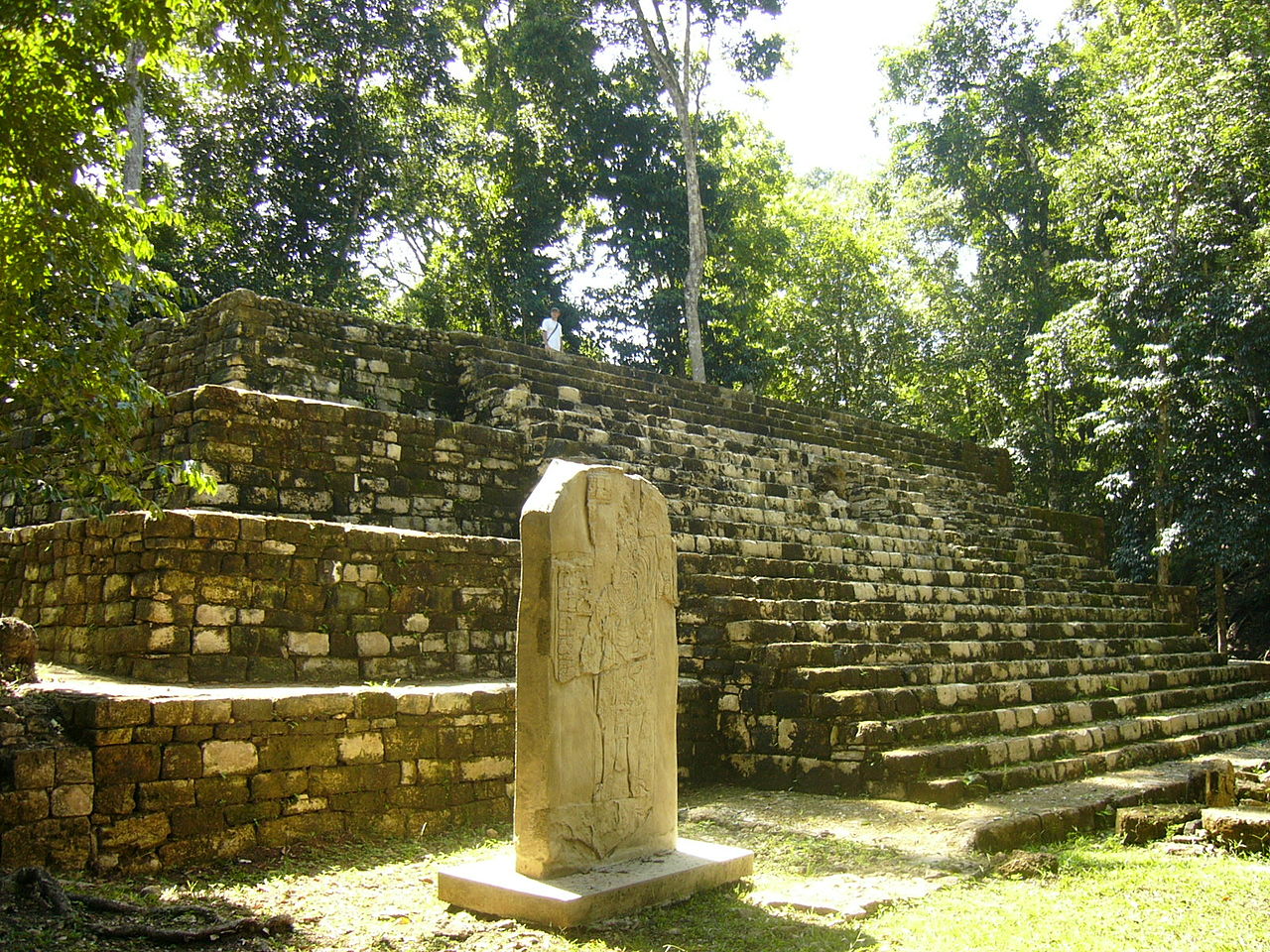
Photo Jacob Rus · CC BY-SA 2.0Source file on Wikimedia Commons
Overview
About this site
Overview
Yaxchilan is an ancient Maya city on the bank of the Usumacinta River in the state of Chiapas, Mexico. In the Late Classic Period it was one of the most powerful Maya states along the course of the river, with Piedras Negras as its major rival.
The site is particularly known for its well-preserved sculptured stone lintels set above the doorways of the main structures. These lintels, together with the stelae erected before the major buildings, carry hieroglyphic texts describing the dynastic history of the city.
Read on Wikipedia2 min readCC BY-SA 4.0
Where it sits in time
The site's dated range, placed against world reference points.
The scale is logarithmic: each step to the left is about ten times older than the last.
Article
Yaxchilan
Yaxchilan lies on the south bank of the river at the apex of a horseshoe-shaped meander, which defends the site on all sides except for a narrow land approach from the south.
SettingSources for this section
- Wikipedia (English): YaxchilanCC BY-SA 4.0
Sources for this section
- Wikipedia (English): YaxchilanCC BY-SA 4.0
Yaxchilan lies on the south bank of the river at the apex of a horseshoe-shaped meander, which defends the site on all sides except for a narrow land approach from the south. It is in Ocosingo Municipality, on the Mexican side of the border with Guatemala. The site is 40 kilometres (25 mi) upriver from Piedras Negras, 21 kilometres (13 mi) from Bonampak, and 80 kilometres (50 mi) downriver from Altar de Sacrificios.
HistorySources for this section
- Wikipedia (English): YaxchilanCC BY-SA 4.0
Sources for this section
- Wikipedia (English): YaxchilanCC BY-SA 4.0
Yaxchilan has its origins in the Preclassic Period and was important throughout the Classic era, dominating smaller sites such as Bonampak. It warred with Palenque in 654. The known history of the city starts with the enthronement of Yopaat B'alam I, most likely on 23 July 359, the founder of a long dynasty. K'inich Tatb'u Skull II was enthroned on 11 February 526 and commissioned a series of carved lintels, including a dynastic list.
The city reached its greatest power under Itzamnaaj B'alam II, who was enthroned in October 681, reigned for more than sixty years and died in 742, and his son Bird Jaguar IV. Itzamnaaj B'alam II oversaw a monumental building programme of richly carved lintels, hieroglyphic stairways and stelae. The dynasty lasted into the early 9th century. Some retrospective inscriptions appear to have been used to rewrite the city's dynastic history to suit Bird Jaguar IV.
NameSources for this section
- Wikipedia (English): YaxchilanCC BY-SA 4.0
Sources for this section
- Wikipedia (English): YaxchilanCC BY-SA 4.0
Epigraphers think the ancient name of the city was probably the same as that of its realm, Pa' Chan, meaning 'Cleft (or broken) Sky'. Désiré Charnay called the ruins 'Lorillard City' and Alfred Maudslay named them 'Menché'. Teoberto Maler gave the modern name, said to mean 'Green Stones' in an unspecified Maya language.
ContextSources for this section
- Wikipedia (English): YaxchilanCC BY-SA 4.0
Sources for this section
- Wikipedia (English): YaxchilanCC BY-SA 4.0
Maya stelae are tall sculpted stone shafts, often paired with low circular stones called altars. The sculpting of these monuments spread across the Maya area in the Classic Period (about 250 to 900 CE), and during that period almost every Maya kingdom in the southern lowlands raised stelae in its ceremonial centre.
Tradition and region
About this kind of monument
Mesoamerican stelae and carved stone
Mesoamerica's civilisations raised carved stone monuments. Maya stelae are tall sculpted stone shafts, often paired with low circular stones called altars, though their actual function is uncertain. Many stelae are carved in low relief, though plain ones are found throughout the Maya region. The sculpting of these monuments spread across the Maya area in the Classic Period (about 250 to 900 CE), and the pairing of sculpted stela and altar is a hallmark of Classic Maya civilisation. The earliest dated stela found in place in the Maya lowlands comes from Tikal in Guatemala, and during the Classic Period almost every Maya kingdom in the southern lowlands raised stelae in its ceremonial centre.
The Olmec colossal heads, much older, are stone representations of heads carved from large basalt boulders, from 1.17 to 3.4 metres high. They date from at least 900 BCE and are a distinctive feature of Olmec civilisation. All portray individuals with distinctive features of the people who still live in Tabasco and Veracruz, and the backs are often flat. The boulders came from the Sierra de los Tuxtlas mountains in Veracruz, and given the weight of the stone, which was moved over 150 kilometres, much labour was needed.
Many Maya stelae carry inscriptions in hieroglyphs with dates in the Long Count calendar, and so can be dated to the day. This makes them among the most precisely dated monuments in the Atlas. They commemorate rulers and events, not the dead in general.
The Atlas's records in Mexico, Guatemala and Belize are mostly Maya sites with stelae, altars and carved monuments.
When visiting, look at the carved figure on the front, which is usually a ruler, and at the glyphs on the sides and back. Many stelae are now protected by roofs.
Paraphrased from Wikipedia: Maya stelae, Wikipedia: Olmec colossal heads, Wikipedia: Stele · CC BY-SA 4.0
From the article
Dated moments in the story
- 514 CE
In 514, Knot-eye Jaguar I was taken captive by Ruler C of Piedras Negras, as depicted on Lintel 12 from that city, where he is shown kneeling before the enemy king with his wrists bound.
Source - 537 CE
Little is known of the history of Yaxchilan from 537 to 629, although four kings are known to have reigned in this period.
Source - 564 CE
Knot-eye Jaguar II is known to have captured the lord of Lacanha in 564, one of the few events that can be identified from this period.
Source - 646 CE
In 646 or 647 he captured a lord from the site of Hix Witz (meaning "Jaguar Hill"), somewhere on the north side of the Usumacinta, most likely Zapote Bobal or Pajaral located to the south of the San Pedro Martir river in the Petén department of Guatemala, based on the findings of epigrapher David Stuart (Mayanist).
Source - 681 CE
Before the rule of king Itzamnaaj Balam II, who reigned from 681 to 742, the city was relatively small.
Source - 715 CE
At times the sites of Lacanha and Bonampak appear to have been under his domination, although this region was controlled by Toniná in 715. In 689, relatively early in his reign, Itzamnaaj B'alam II is recorded as having captured Aj Sak Ichiy Pat.
Source - 726 CE
In 726, Yaxchilan was defeated by its rival Piedras Negras, an event described on Piedras Negras Stela 8. A sajal (subordinate lord) of Itzamnaaj B'alam II was captured by the enemy city, an event that is completely absent from inscriptions at Yaxchilán itself although, importantly, there is no false claim of victory.
Source - 732 CE
Similarly, his capture of a lord of Hix Witz in 732 is compared to Bird Jaguar III's victory over the same site.
Source - 742 CE
Yaxchilan reached its greatest power during the reigns of King Itzamnaaj B'alam II, who died in his 90s in 742, and his son Bird Jaguar IV.
Source - 752 CE
Bird Jaguar IV wears the same costume that his father is depicted wearing on Lintel 26. The capture event depicted on Lintel 16 took place in 752. Lintel 17 was another lintel from a doorway in Structure 21 that is now in the British Museum.
Source - 759 CE
Yaxchilan retaliated in 759, gaining a victory over its enemy.
Source - 1882
Lintel 16 also spanned a doorway in Structure 21 and was removed to the British Museum in 1882–3. It was sculpted from limestone and was originally set above the central doorway of the central room.
Source - 1970
From 1970 onwards, Ian Graham made numerous visits to Yaxchilan and recorded the inscriptions there.
Source - 1982
Structure 20 was excavated by Ian Graham in 1982, during the excavations a hieroglyphic step was found in front of the building, it was reburied in order to preserve it.
Source
Photographs
8 photographs, each with its author and licence
More photographs
Lore
Evidence & Lore
What the sources actually support — and, kept apart, what has been claimed.
What the evidence supports
Dates
Est. 1200 BCE–900 CEHow this date was established: Type comparisonTypological estimate, not a date for this site: a other in Mesoamerica is normally dated between 1200 BCE and 900 CE (Atlas typological table).Source for this date
Measured facts
- Location
- Usumacinta River, Chiapas, MexicoSource: Location
- Major rival
- Piedras NegrasSource: Major rival
- Notable ruler
- Itzamnaaj Balam IISource: Notable ruler
- Important inscription
- Hieroglyphic Stairway 1Source: Important inscription
- Modern research
- INAH conducted archaeological research in 1972–1973, in 1983, and in the early 1990sSource: Modern research
- Access
- One-hour boat ride from Frontera CorozalSource: Access
- Culture
- Maya civilizationSource: Culture
Where it stands
Mexico
The pin marks the monument itself — its exact point.
- Coordinates
- 16°54′00″ N, 90°58′00″ WFor a GPS or map app: 16.90000, -90.96667
Access is as our sources describe it; we have not visited the site to check.
Nearby
The closest sites in the Atlas, by straight line.





Sources
Every record behind this page, with the link it came from.
3 sources behind this page
- 01Wikidata Q662263wikidata.org
- 02Fringe claim sourceen.wikipedia.org
- 03Wikipedia (en)en.wikipedia.org
Image files
- Yaxchilan 1.jpgJacob RusCC BY-SA 2.0
- Labyrinth Entrance ... (49536023947).jpgBernard DUPONT from FRANCECC BY-SA 2.0
- Buildings222324Yaxchilan.JPGThelmadatterCC BY-SA 3.0
- Foto en la Zona Arqueológica de Yaxchilan 01.jpgZoRrO0880CC BY-SA 4.0
- Foto en la Zona Arqueológica de Yaxchilan 02.jpgZoRrO0880CC BY-SA 4.0
- Going down the Great Stairway ... (49536474067).jpgBernard DUPONT from FRANCECC BY-SA 2.0
- Inside, Yaxchilan, Mx (30910276721).jpgRod WaddingtonCC BY-SA 2.0
- LanchaYaxchilanBeach.JPGThelmadatterCC BY-SA 3.0
Report a correctionWrong date, name, photograph or source? Tell us and it will be put right.
Around this place
The ten nearest sites, by compass
Credit
Text, licence and sources
Adapted from the Wikipedia article "Yaxchilan" (English), licensed CC BY-SA 4.0; authors are listed in the page history. Reused under CC BY-SA 4.0. Read on Wikipedia · Edit history and authors
- Wikipedia (English): YaxchilanCC BY-SA 4.0
- Wikidata Q662263CC0
- Fringe claim sourceCC BY-SA 4.0