
MegalithFringe site
Tenam Puente
Datedc. 300–1200 CE
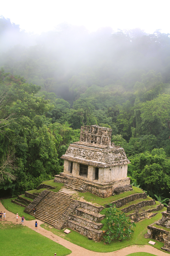
Photo Strongilocentrotus · CC BY-SA 4.0Source file on Wikimedia Commons
Overview
About this site
What the sources say
Tenam Puente (Tenam Puente Archaeological Zone) is an archaeological site of the Maya culture located in the Balum Canan valley, in the municipality of La Trinitaria, 12 kilometers south of Comitán, Chiapas, in Mexico. It is accessed by a deviation from Federal Highway 190 that leads to La Trinitaria.
Read on Wikipedia7 min readCC BY-SA 4.0
Where it sits in time
The site's dated range, placed against world reference points.
The scale is logarithmic: each step to the left is about ten times older than the last.
The full article
Tenam Puente: the whole story
In briefSources for this section
- Wikipedia (English): Tenam PuenteCC BY-SA 4.0
Sources for this section
- Wikipedia (English): Tenam PuenteCC BY-SA 4.0
Tenam Puente is an archaeological site of the Maya culture in the Balum Canan valley, in the municipality of La Trinitaria, 12 kilometers south of Comitán, Chiapas, in Mexico. It is reached by a deviation from Federal Highway 190 that leads to La Trinitaria. The name Tenam derives from the Nahuatl tenamitl, which means wall or fortress, while Puente alludes to an old farm that existed at the beginning of the 20th century, whose land today forms the Francisco Sarabia ejido.
Although the site dates back to the classic period (between 300 and 600 AD), everything indicates that its main period of occupation was the early Postclassic (approximately between 900 and 1200 AD), when the Mayan sites of the central area were abandoned. The site represents the transition from the Classic Period to the Postclassic, one of the least studied stages of Chiapas archaeology. The last date of registration of the place is around the year 874 AD. Tenam Puente and nearby Chinkultic were a modest power on the western fringe of the Maya highlands and appear to have survived until around 1200 AD, before being abandoned for reasons that are still unclear. It was first mentioned in the book Tribes and Temples, edited by Frans Blom and Oliver La Farge in 1928.
Its strategic location let its inhabitants control the route of important commercial networks linking the highlands of Chiapas and Guatemala with the central depression of Chiapas. Ceramics from the excavations show very active trade with distant areas, including snails from the Gulf of Mexico. Burials show the presence of important people who received numerous offerings, such as vessels, jade objects, ornaments of shell and stingray spine. The finds confirm that Tenam Puente took part in the last stage of the Classic Mayan culture and the transition to the Early Postclassic, when metallurgy becomes stronger and objects made of alabaster appear.
The site was built on a mountain with a series of calcareous hills, about 1,600 to 1,700 m above sea level, dominating the comiteca plain that extends to the Montebello Lakes. It consists of large platforms with monumental retaining walls, some with stone ramps in the form of buttresses. The nuclear zone is made up of a little more than 60 structures spread over approximately 30 hectares. Most of the important buildings are on the north side, in the Acropolis, with its structures 4 and 7, the highest point of the site. To build it the hills were levelled with high and long terraces, the upper ones up to 20 meters high, and the buildings were arranged around patios and plazas. A group to the south corresponds to temples and residences of the upper classes.
EtymologySources for this section
- Wikipedia (English): Tenam PuenteCC BY-SA 4.0
Sources for this section
- Wikipedia (English): Tenam PuenteCC BY-SA 4.0
The word Tenam is a hybrid toponymic: Tenam derives from the Nahuatl tenamitl which means 'wall' or 'fortress', while the word Puente alludes to the name of an old farm existing at the beginning of the 20th century, whose land today constitutes the Francisco Sarabia ejido, where this attraction is now located.
The site represents the transition from the Classic Period to the Postclassic, being one of the least studied stages of Chiapas archaeology.
History and datingSources for this section
- Wikipedia (English): Tenam PuenteCC BY-SA 4.0
Sources for this section
- Wikipedia (English): Tenam PuenteCC BY-SA 4.0
Although the site dates back to the classic period (between 300 and 600 AD), everything indicates that its main period of occupation corresponds to the early Postclassic (approximately between 900 and 1200 AD), when the Mayan sites of the central area were abandoned, which today occupies the department of Petén, in Guatemala.
The site represents the transition from the Classic Period to the Postclassic, being one of the least studied stages of Chiapas archaeology.
It was contemporary with the splendor of the Toltec culture of Chichén-Itzá. The last date of registration of the place is around the year 874 AD.
The Mayan collapse in the 9th century was far more detrimental to lowland Maya centers such as Palenque and Yaxchilán, than smaller highland centers like Tenam Puente. In fact, the highland cities that survived the initial collapse may even have benefited from the abrupt decline of their lowland competitors. Tenam Puente, as well as nearby Chinkultic, were a modest power on the western fringe of the Maya world's highlands, and appear to have survived until around 1200 AD, before finally being abandoned, for reasons that are still unclear.
Trade
The strategic location of Tenam Puente allowed its inhabitants to have access to and exercise control over the route of the important commercial networks that linked the highlands of Chiapas and Guatemala with the central depression of Chiapas. The ceramic collections from the site's excavations show a very active trade with other areas far removed from the Comitán region, such as snails from the Gulf of Mexico.
On the other hand, the discovered burials show the presence of great characters to whom numerous offerings were deposited, such as vessels, jade objects (ya'ax chich'), ornaments made of shell and spine of stingray. Thanks to all these excavations, burials and explorations.
With the findings, it has been possible to confirm that Tenam Puente participated in the last stage of the Classic Mayan culture, which represents the transition to the Early Postclassic, when the metallurgy becomes stronger and objects made of alabaster appear.
ScansSources for this section
- Wikipedia (English): Tenam PuenteCC BY-SA 4.0
Sources for this section
- Wikipedia (English): Tenam PuenteCC BY-SA 4.0
Tenam Puente was mentioned for the first time in the book Tribes and Temples, edited by Frans Blom and Oliver La Farge in 1928.
DescriptionSources for this section
- Wikipedia (English): Tenam PuenteCC BY-SA 4.0
Sources for this section
- Wikipedia (English): Tenam PuenteCC BY-SA 4.0
The archaeological zone of Tenam Puente was built in the southern border area of the Mayan zone, in a strategic position on a mountain with a series of calcareous hills that divide the Altos Orientales with the Central Depression of Chiapas, about 1,600 to 1,700 m above sea level, which dominates the entire comiteca plain that extends to the Montebello Lakes, in the east of the state of Chiapas.
Tenam Puente was built on large and spectacular platforms with monumental retaining walls, access to which is restricted as you go up. These large walls were arranged on five slopes, thus forming open and closed squares on which the main buildings were distributed, some of which have stone ramps in the form of buttresss as a characteristic element.
The nuclear zone of the settlement is made up of a little more than 60 structures distributed in a territorial extension of approximately 30 hectares.
Most of the buildings and the most important are on the north side, in what is called the Acropolis, with its structures 4 and 7, it is the highest point of this site, which offers good views throughout the area .
For the construction of the Acropolis, it was necessary to level the hills by means of high and long terraces built at different levels, which decrease in size and height as you go up. The upper terraces, up to 20 meters high, are formed by stepped bodies. The buildings were built around a series of patios and plazas.
Another group to the south corresponds to temples and residences of the upper classes, distributed around closed squares, with shrines, squares and patios that were delimited by various constructions, as well as platforms with large rooms on top.
In the surroundings of Tenam Puente are the vestiges of the old population, although very modified by the current agricultural work.
The spatial composition of the buildings in the area is very similar to the architecture of other Mayan sites in the Central Depression of Chiapas (semi-flat area bordered by the Sierra Madre de Chiapas, the Central Plateau and the Northern Mountains), on the bed of the Grijalva River and its tributaries, a large number of sites with very similar architectural characteristics and construction techniques are distributed, based on blocks of limestone perfectly cut and assembled without mortar and without lime.
The finishes were applied with stucco, which is still preserved in some walls, floors and stairss, you can also see some stone lajas floors.
Like many sites in the Chiapas highlands, Tenam Puente is notable for its lack of ornamentation, such as arches, corbelss, and crestings. In the same way, only one stele has been found dated with the year 790, which is kept in the archaeological museum of Tuxtla Gutiérrez.
How this page was madeSources for this section
- Wikipedia (English): Tenam PuenteCC BY-SA 4.0
Sources for this section
- Wikipedia (English): Tenam PuenteCC BY-SA 4.0
The summary at the top of this page was written by Claude Sonnet 5.5 (2026-11-06) from the cited Wikipedia article “Tenam Puente”. The numbers in it were checked automatically against the source text. The rest of the page is the article itself, the structured records and computed distances.
Tradition and region
About this kind of monument
Mesoamerican stelae and carved stone
Mesoamerica's civilisations raised carved stone monuments. Maya stelae are tall sculpted stone shafts, often paired with low circular stones called altars, though their actual function is uncertain. Many stelae are carved in low relief, though plain ones are found throughout the Maya region. The sculpting of these monuments spread across the Maya area in the Classic Period (about 250 to 900 CE), and the pairing of sculpted stela and altar is a hallmark of Classic Maya civilisation. The earliest dated stela found in place in the Maya lowlands comes from Tikal in Guatemala, and during the Classic Period almost every Maya kingdom in the southern lowlands raised stelae in its ceremonial centre.
The Olmec colossal heads, much older, are stone representations of heads carved from large basalt boulders, from 1.17 to 3.4 metres high. They date from at least 900 BCE and are a distinctive feature of Olmec civilisation. All portray individuals with distinctive features of the people who still live in Tabasco and Veracruz, and the backs are often flat. The boulders came from the Sierra de los Tuxtlas mountains in Veracruz, and given the weight of the stone, which was moved over 150 kilometres, much labour was needed.
Many Maya stelae carry inscriptions in hieroglyphs with dates in the Long Count calendar, and so can be dated to the day. This makes them among the most precisely dated monuments in the Atlas. They commemorate rulers and events, not the dead in general.
The Atlas's records in Mexico, Guatemala and Belize are mostly Maya sites with stelae, altars and carved monuments.
When visiting, look at the carved figure on the front, which is usually a ruler, and at the glyphs on the sides and back. Many stelae are now protected by roofs.
Paraphrased from Wikipedia: Maya stelae, Wikipedia: Olmec colossal heads, Wikipedia: Stele · CC BY-SA 4.0
From the article
Dated moments in the story
- 600 CE
Although the site dates back to the classic period (between 300 and 600 AD), everything indicates that its main period of occupation corresponds to the early Postclassic (approximately between 900 and 1200 AD), when the Mayan sites of the central area were abandoned, which today occupies the department of Petén, in...
Source - 790 CE
In the same way, only one stele has been found dated with the year 790, which is kept in the archaeological museum of Tuxtla Gutiérrez.
Source - 874 CE
The last date of registration of the place is around the year 874 AD.
Source - 1928
Tenam Puente was mentioned for the first time in the book Tribes and Temples, edited by Frans Blom and Oliver La Farge in 1928.
Source
Photographs
8 photographs, each with its author and licence
More photographs
Lore
Evidence & Lore
What the sources actually support — and, kept apart, what has been claimed.
What the evidence supports
Dates
300–1200 CEHow this date was established: Historical sourcesThe range reflects the stated Classic and Postclassic occupation periods.Source for this date
Measured facts
- Location
- Balum Canan valley, La Trinitaria, Chiapas, MexicoSource: Location
- Culture
- MayaSource: Culture
- Classic-period date
- 300 to 600 ADSource: Classic-period date
- Main occupation
- approximately 900 to 1200 ADSource: Main occupation
- Distance from Comitán
- 12 kilometersSource: Distance from Comitán
- Last registered date
- around 874 ADSource: Last registered date
- Start time
- 300s CESource: Start time
- End time
- 1200s CESource: End time
Where it stands
Mexico
The pin marks the monument itself — its exact point.
- Coordinates
- 16°07′59″ N, 92°05′50″ WFor a GPS or map app: 16.13306, -92.09722
Access is as our sources describe it; we have not visited the site to check.
Nearby
The closest sites in the Atlas, by straight line.




Sources
Every record behind this page, with the link it came from.
2 sources behind this page
- 01Wikidata Q2867454wikidata.org
- 02Fringe claim sourceen.wikipedia.org
Image files
- Estructura 7-Tenam Puente.JPGStrongilocentrotusCC BY-SA 4.0
- Tenam 0200.JPGNoche de la penaCC BY-SA 3.0
- Tenam 0203.JPGNoche de la penaCC BY-SA 3.0
- BallcourtPiecesTenamTuxtla.JPGAlejandroLinaresGarciaCC BY-SA 4.0
- Tenam Puente. - panoramio.jpgNacasmaCC BY 3.0
- Tenam Puente. - panoramio (1).jpgNacasmaCC BY 3.0
- Zona Arqueológica de Tenam Puente.jpgPatricia Alzuarte DíazCC BY-SA 3.0
- Juego de pelota 1-Tenam puente.JPGStrongilocentrotusCC BY-SA 4.0
Report a correctionWrong date, name, photograph or source? Tell us and it will be put right.
Around this place
The ten nearest sites, by compass
Credit
Text, licence and sources
Text from the Wikipedia article "Tenam Puente" (English), licensed CC BY-SA 4.0; authors are listed in the page history. Reused under CC BY-SA 4.0. Read on Wikipedia · Edit history and authors
- Wikipedia (English): Tenam PuenteCC BY-SA 4.0
- Wikidata Q2867454CC0