
MegalithFringe site
Chunchucmil
Datedc. 400–650 CE
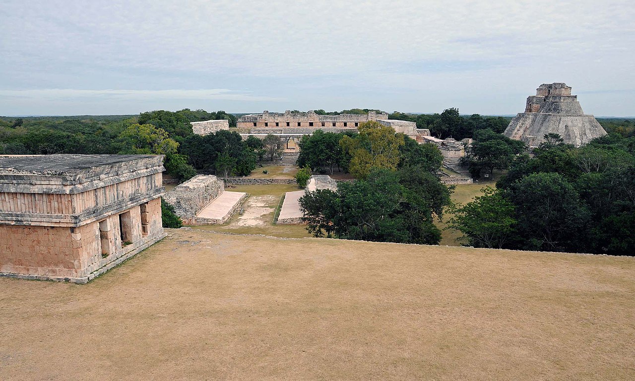
Photo David R. Hixson · CC BY-SA 2.5Source file on Wikimedia Commons
Overview
About this site
Overview
Chunchucmil was a large, sprawling pre-Columbian Maya city in the western part of what is now the state of Yucatán, Mexico. It was most populous in the Middle Classical Period (400–650 AD), with an estimated 31,000–43,000 people within the central 25 km2 area.
Virtually no monuments (stelae) or other grand sculptures have been found there. This lack of royal monuments, combined with other archaeological data, may indicate that the city was not ruled by a single divine king, as most other Maya polities were, but was instead a commercial center organized by various lineages and focused on funneling goods between regions.
Read on Wikipedia6 min readCC BY-SA 4.0
Where it sits in time
The site's dated range, placed against world reference points.
The scale is logarithmic: each step to the left is about ten times older than the last.
Article
Chunchucmil
It extends onto the ejido lands of at least five modern communities: Chunchucmil, Kochol, San Mateo, Coahuila and Halachó.
SettingSources for this section
- Wikipedia (English): ChunchucmilCC BY-SA 4.0
Sources for this section
- Wikipedia (English): ChunchucmilCC BY-SA 4.0
The site center lies ca. 27 km (16.8 mi) inland from the Gulf of Mexico, approximately halfway between the coast and the next largest archaeological site, Oxkintok. It extends onto the ejido lands of at least five modern communities: Chunchucmil, Kochol, San Mateo, Coahuila and Halachó. Most of it lies within the municipality of Maxcanú, with a portion in the municipality of Halachó.
The site stands on a narrow band of semi-arid terrain regarded as the driest in the Maya area, with less than 800 mm (31.5 in) of annual rainfall. Nearly fifty percent of the surface is exposed limestone bedrock, soils are rarely more than a few centimeters deep, and the vegetation is scrub forest dominated by acacia and other drought-resistant species. How such a large city sustained itself in one of the poorest regions for agriculture remains one of the questions about the site. The city lay at the edge of this zone, where the dry plains give way to wetlands: seasonally inundated savannas, freshwater petenes (ojos de agua) and, further west, a brackish mangrove estuary near the coastal site of Canbalam. It is likely that the city was purposefully placed to use multiple ecological zones, including the salt-beds of the Celestún peninsula, and to reach the circum-peninsular canoe trade route, with Canbalam as its port of entry.
DatingSources for this section
- Wikipedia (English): ChunchucmilCC BY-SA 4.0
Sources for this section
- Wikipedia (English): ChunchucmilCC BY-SA 4.0
Ceramic data indicate that the Chunchucmil region was occupied from the Middle Preclassic (Middle Formative) through the Postclassic periods. Test excavations within the architectural groups indicate that the city reached its apogee in the latter part of the Early Classic and the early part of the Late Classic, when it attained its maximum extent, population and structural density. This period is defined in some areas as the Middle Classic. The city appears to have declined during the latter part of the Late Classic. The Terminal Classic (or Puuc) occupation is ephemeral at best, and the Postclassic occupation consisted of squatter-like settlement. A few early colonial homesteads have been found, but the region was largely abandoned between the Postclassic and the beginnings of the cattle ranches and henequen haciendas of historic and modern times.
DescriptionSources for this section
- Wikipedia (English): ChunchucmilCC BY-SA 4.0
Sources for this section
- Wikipedia (English): ChunchucmilCC BY-SA 4.0
Estimates of the site's size, studied by the Pakbeh Regional Economy Project (at work there since the mid-1990s under Dr. Bruce H. Dahlin), range from 25 km2 for the more compact urban settlement to around 64 km2 for the city with its suburbs and farmsteads. This places Chunchucmil among the largest and most densely settled ancient Maya polities.
The Classic Period site center is dominated by over a dozen pyramids ranging from 8 to 18 m (26 to 60 ft) in height. Each is part of a quadrangle group, an enclosed courtyard flanked on one side by a pyramid facing inward and on the other three sides by ranged and compact structures. Each courtyard has a small central platform interpreted as a focal point of ritual activity. These groups likely housed the upper-echelon elites, and each major group is connected to the others by a network of sacbeob (stone causeways). If this indicates cooperation or competition among the resident lineages, the political structure may have resembled the multepal system, or rulership through council, suggested for the later Maya capital of Chichen Itza.
Residential architecture often follows the same pattern, with structures on four sides of a small plaza. These clusters are encircled by low stone walls (albarradas) that bound the residential lot (solar), and the whole unit is today called an albarrada group. Unlike at most Maya sites, the groups have clear boundaries between house lots, which helps researchers study settlement patterns, population and social organization. Many residential groups had a small shrine. One shrine excavated and consolidated at the Lool Group is in talud-tablero form, a style most famous at Central Mexican sites such as Teotihuacan, and a vessel beneath its stair replicated the pottery of that city. This suggests participation in the wider Mesoamerican communication sphere, though not direct Teotihuacan influence, and no other excavated structure shows demonstrable Teotihuacan influence.
The albarradas give the site a honeycomb appearance on a map. The spaces between them form footpaths (callejuelas) radiating from the center into the dense residential zone. In the seasonally inundated western wetlands, researchers have found rock alignments called andadores that connect the periphery to outlying settlements. The longest suggest a connection with the coast near Canbalam.
ArchaeologySources for this section
- Wikipedia (English): ChunchucmilCC BY-SA 4.0
Sources for this section
- Wikipedia (English): ChunchucmilCC BY-SA 4.0
A stone wall visible in aerial photographs roughly encircles 350,000 square metres of the site center, including most of the major quadrangle groups. Reconnaissance in the late 1990s found that it stood between 1 and 1.5 m tall, had a perimeter of 1.8 km, and was incomplete, forming a large C-shape with a 340 m wide gap open to the west. It runs above every major feature of the site, so it was likely the last feature built, and its stones were robbed from nearby structures rather than freshly quarried. It has been hypothesized that the barricade was built rapidly at the end of the city's history, possibly to protect the remaining inhabitants from an invasion that arrived before it was completed.
The chipped-stone assemblage is dominated by obsidian prismatic blades, most of which were likely imported in finished form. The El Chayal source, the most common at Chunchucmil, lies nearly 1000 km (621 mi) away in Guatemala, which indicates close ties with external trade routes. Non-obsidian stone such as chert, chalcedony and quartz is much less common and was mostly obtained locally from nodules in the limestone bedrock, but was of poor quality. The site is also notable for the likely presence of a marketplace.
NameSources for this section
- Wikipedia (English): ChunchucmilCC BY-SA 4.0
Sources for this section
- Wikipedia (English): ChunchucmilCC BY-SA 4.0
The name Chunchucmil was originally used for a freshwater well (Ch'en Chun Chukum), the central water source of the cattle ranch that grew into the henequen hacienda of Chunchucmil. The words literally mean the well at the base of the Chukum tree (Havardia albicans). Archaeologists gave the ruins the name in the 1970s after the nearest modern community; local Maya villagers have no single term for the ruins, since the ancient city encompasses most of their lands. The explorer John Lloyd Stephens traveled within a few kilometers of the site, but it went relatively unnoticed by Maya scholars for more than a century.
Tradition and region
About this kind of monument
Mesoamerican stelae and carved stone
Mesoamerica's civilisations raised carved stone monuments. Maya stelae are tall sculpted stone shafts, often paired with low circular stones called altars, though their actual function is uncertain. Many stelae are carved in low relief, though plain ones are found throughout the Maya region. The sculpting of these monuments spread across the Maya area in the Classic Period (about 250 to 900 CE), and the pairing of sculpted stela and altar is a hallmark of Classic Maya civilisation. The earliest dated stela found in place in the Maya lowlands comes from Tikal in Guatemala, and during the Classic Period almost every Maya kingdom in the southern lowlands raised stelae in its ceremonial centre.
The Olmec colossal heads, much older, are stone representations of heads carved from large basalt boulders, from 1.17 to 3.4 metres high. They date from at least 900 BCE and are a distinctive feature of Olmec civilisation. All portray individuals with distinctive features of the people who still live in Tabasco and Veracruz, and the backs are often flat. The boulders came from the Sierra de los Tuxtlas mountains in Veracruz, and given the weight of the stone, which was moved over 150 kilometres, much labour was needed.
Many Maya stelae carry inscriptions in hieroglyphs with dates in the Long Count calendar, and so can be dated to the day. This makes them among the most precisely dated monuments in the Atlas. They commemorate rulers and events, not the dead in general.
The Atlas's records in Mexico, Guatemala and Belize are mostly Maya sites with stelae, altars and carved monuments.
When visiting, look at the carved figure on the front, which is usually a ruler, and at the glyphs on the sides and back. Many stelae are now protected by roofs.
Paraphrased from Wikipedia: Maya stelae, Wikipedia: Olmec colossal heads, Wikipedia: Stele · CC BY-SA 4.0
From the article
Dated moments in the story
- 650 CE
Chunchucmil was most populous in the Middle Classical Period (400–650 AD), with an estimated 31,000–43,000 (within the central 25 km2 area) people.
Source
Photographs
5 photographs, each with its author and licence
More photographs
Lore
Evidence & Lore
What the sources actually support — and, kept apart, what has been claimed.
What the evidence supports
Dates
400–650 CEHow this date was established: Stated by the sourceThe source identifies this period as the city's population peak.Source for this date
Measured facts
- Location
- Western Yucatán, MexicoSource: Location
- Occupation span
- Middle Preclassic through PostclassicSource: Occupation span
- Peak extent
- Late Early Classic and early Late ClassicSource: Peak extent
- Estimated population
- 31,000–43,000 within the central 25 km2 areaSource: Estimated population
- Monuments
- Virtually no stelae or other grand sculptures have been foundSource: Monuments
- Later occupation
- Postclassic settlement was described as squatter-likeSource: Later occupation
- Culture
- Maya civilizationSource: Culture
Where it stands
Mexico
The pin marks the monument itself — its exact point.
- Coordinates
- 20°38′19″ N, 90°11′25″ WFor a GPS or map app: 20.63856, -90.19022
Access is as our sources describe it; we have not visited the site to check.
Nearby
The closest sites in the Atlas, by straight line.


Sources
Every record behind this page, with the link it came from.
2 sources behind this page
- 01Wikidata Q2664375wikidata.org
- 02Fringe claim sourceen.wikipedia.org
Image files
- Chunchucmil-mounds.jpgDavid R. HixsonCC BY-SA 2.5
- Chunchucmil-marketplace.jpgBruce DahlinCC BY-SA 2.5
- Chunchucmil-Sacbe.jpgDavid R. HixsonCC BY-SA 2.5
- Chunchucmil-callejuela.jpgDavid R. HixsonCC BY-SA 2.5
- Chun-airsar-dem-orthophoto.jpgDavid R. Hixson / Chunchucmil at en.wikipediaCC BY-SA 3.0
Report a correctionWrong date, name, photograph or source? Tell us and it will be put right.
Around this place
The ten nearest sites, by compass
Credit
Text, licence and sources
Adapted from the Wikipedia article "Chunchucmil" (English), licensed CC BY-SA 4.0; authors are listed in the page history. Reused under CC BY-SA 4.0. Read on Wikipedia · Edit history and authors
- Wikipedia (English): ChunchucmilCC BY-SA 4.0
- Wikidata Q2664375CC0