.jpg/1920px-Pasargadae%2C_the_first_capital_of_the_Achaemenid_Empire%2C_Iran_(48835447413).jpg 1920w)
MegalithFringe siteUNESCO World Heritage
Pasargadae
Datedc. 600–500 BCE
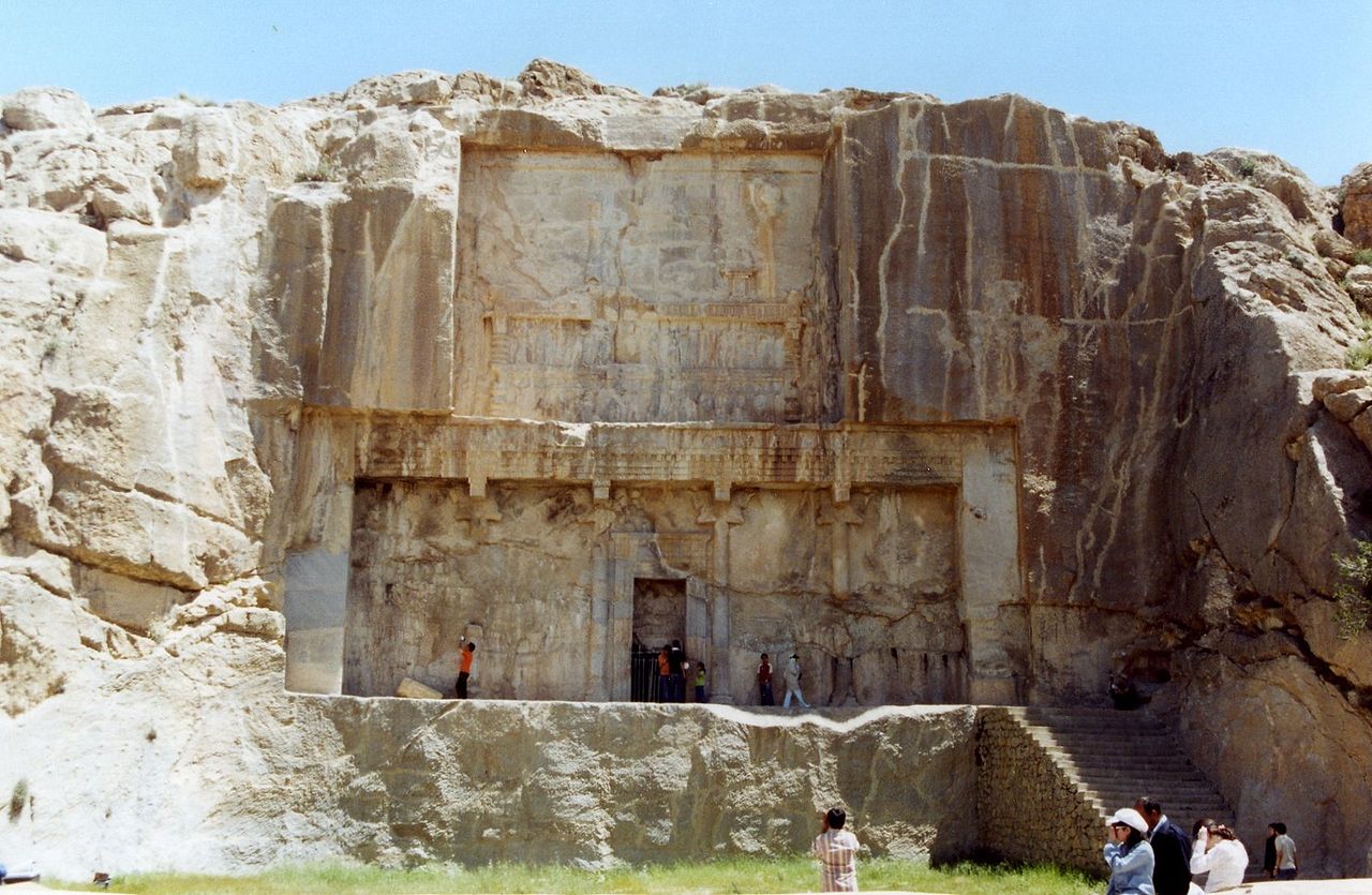
Photo Carole Raddato from Frankfurt, Germany · CC BY-SA 2.0Source file on Wikimedia Commons
Overview
About this site
Overview
Pasargadae (Persian: Pāsārgād) was the capital of the Achaemenid Empire under Cyrus the Great (559–530 BC). It lies just north of the town of Madar-e-Soleyman, about 90 kilometres (56 mi) to the northeast of Shiraz, in Fars province, Iran, and is one of Iran's UNESCO World Heritage Sites.
The archaeological site covers 1.6 square kilometres (0.62 sq mi). It includes a structure commonly believed to be the mausoleum of Cyrus, the fortress of Toll-e Takht on a nearby hill, and the remains of two royal palaces and gardens.
Read on Wikipedia3 min readCC BY-SA 4.0
Age sources
How old this site is, and who says so.
Range across all claimsc. 600–500 BCE
MeasuredWhat this badge means
A physical measurement of this site: a radiocarbon date, a tree-ring count, a luminescence date, or a record that can itself be dated.
- 600–500 BCEHistorical recordThe source gives 550 BCE as the date when Cyrus founded the city near his victory over Astyages. The source gives one year, so it is shown as a 100-year windowSource: en.wikipedia.org
- 600–501 BCEWikipedia: Pasargadae (infobox)Source: en.wikipedia.org
Where it sits in time
The site's dated range, placed against world reference points.
The scale is logarithmic: each step to the left is about ten times older than the last.
Article
Pasargadae
There is no firm evidence identifying the tomb as that of Cyrus, although Greek historians say that Alexander believed it was.
DescriptionSources for this section
- Wikipedia (English): PasargadaeCC BY-SA 4.0
Sources for this section
- Wikipedia (English): PasargadaeCC BY-SA 4.0
The most important monument is the tomb attributed to Cyrus the Great. Six broad steps lead to the sepulchre, whose chamber measures 3.17 metres (10.4 ft) long by 2.11 metres (6 ft 11 in) wide by 2.11 metres (6 ft 11 in) high and has a low and narrow entrance. The main decoration is a rosette design over the door within the gable. There is no firm evidence identifying the tomb as that of Cyrus, although Greek historians say that Alexander believed it was.
The palace complex was laid out as an extensive pattern of gardens stretching from the Tomb of Cyrus to the fortress of Tall-i Takht, about three kilometres away, with various palaces and other buildings. The Pasargadae gardens provide the earliest known example of the Persian chahar bagh, or fourfold garden design. Gate R, at the eastern edge of the palace area, is the oldest known freestanding propylaeum and may have been the architectural predecessor of the Gate of All Nations at Persepolis.
The remains of the tomb of Cambyses II, son and successor of Cyrus, have been found near the fortress of Toll-e Takht and were identified in 2006.
HistorySources for this section
- Wikipedia (English): PasargadaeCC BY-SA 4.0
Sources for this section
- Wikipedia (English): PasargadaeCC BY-SA 4.0
Pasargadae was founded in the 6th century BCE as the first capital of the Achaemenid Empire by Cyrus the Great, near the site of his victory over the Median king Astyages in 550 BCE. The city is named after his own royal clan. It remained the Achaemenid capital until Darius moved the capital to Persepolis.
NameSources for this section
- Wikipedia (English): PasargadaeCC BY-SA 4.0
Sources for this section
- Wikipedia (English): PasargadaeCC BY-SA 4.0
The name derives from Pāθra-gadā, literally protective club or strong club.
Research historySources for this section
- Wikipedia (English): PasargadaeCC BY-SA 4.0
Sources for this section
- Wikipedia (English): PasargadaeCC BY-SA 4.0
The site was first explored archaeologically by Ernst Herzfeld in 1905 and in one excavation season in 1928, together with Friedrich Krefter. Sir Aurel Stein completed a site plan in 1934, and in 1935 Erich F. Schmidt produced aerial photographs of the entire complex. An Iranian team led by Ali Sami worked there from 1949 to 1955, and a British Institute of Persian Studies team led by David Stronach excavated from 1961 to 1963.
During the 1960s a pot-hoard known as the Pasargadae Treasure was excavated near the foundations of Pavilion B. Dating to the 5th-4th centuries BC, it consists of ornate Achaemenid jewellery of gold and precious gems and is now housed in the National Museum of Iran and the British Museum. Geomagnetic surveys by the Iranian Cultural Heritage Organization and the Maison de l'Orient et de la Méditerranée of the University of Lyon continued from 2000 until 2008, and a joint Italian-Iranian team excavated in 2006-2007.
InterpretationSources for this section
- Wikipedia (English): PasargadaeCC BY-SA 4.0
Sources for this section
- Wikipedia (English): PasargadaeCC BY-SA 4.0
The design of the tomb is credited to Mesopotamian or Elamite ziggurats, while the cella is usually attributed to earlier Urartu tombs. The art and architecture of Pasargadae exemplify a Persian synthesis of various traditions, drawing on precedents from Elam, Babylon, Assyria and ancient Egypt, with some Anatolian influences. The architecture shows Elamite and Egyptian or Phoenician decoration as well as Ionian Greek building techniques.
ConservationSources for this section
- Wikipedia (English): PasargadaeCC BY-SA 4.0
Sources for this section
- Wikipedia (English): PasargadaeCC BY-SA 4.0
Concern has been expressed about the effect of the Sivand Dam, built between Pasargadae and Persepolis. Construction began on 19 April 2007, with the height of the waterline limited to mitigate damage to the ruins. Archaeologists agree that increased humidity from the reservoir will speed the deterioration of the remains, and of the two sites, Pasargadae is considered the more threatened.
Tradition and region
About this kind of monument
Ziggurats of Mesopotamia and Iran
A ziggurat is a massive structure built in ancient Mesopotamia and Iran in the form of a terraced compound of successively receding storeys or levels. Notable ones include the Great Ziggurat of Ur near Nasiriyah, the Ziggurat of Aqar Quf near Baghdad, the vanished Etemenanki in Babylon, and Chogha Zanbil in Khuzestan. The Sumerians believed that the gods lived in the temple at the top of the ziggurat, so that only priests and other highly respected individuals were allowed to ascend.
The Great Ziggurat of Ur, called Etemenniguru, "house whose foundation creates terror", was built in the Early Bronze Age, in the twenty-first century BCE, by King Ur-Nammu of the Third Dynasty of Ur. It had crumbled to ruins by the sixth century BCE, when it was restored by King Nabonidus. Chogha Zanbil in Iran is an ancient Elamite complex about 30 kilometres south-east of Susa, one of the few ziggurats outside Mesopotamia, dated to the fourteenth or thirteenth century BCE, conventionally 1250 BCE. Etemenanki, the Babylonian ziggurat dedicated to Marduk, lay about 90 kilometres south of Baghdad; some scholars have proposed it as the ziggurat behind the biblical account of the Tower of Babel.
The ziggurat is not built of huge stones: the core was of sun-baked bricks with facings of fired bricks on the outside, each step slightly smaller than the one below, and the facings were often glazed in different colours. Kings sometimes had their names engraved on the glazed bricks, which gives a way to date the building. The Atlas files ziggurats under "other" because they fit no megalithic category.
When visiting, check the security situation, since several sites lie in regions where access is restricted.
Paraphrased from Wikipedia: Ziggurat, Wikipedia: Ziggurat of Ur, Wikipedia: Chogha Zanbil, Wikipedia: Etemenanki · CC BY-SA 4.0
From the article
Dated moments in the story
- 550 BCE
Pasargadae was founded in the 6th century BCE as the first capital of the Achaemenid Empire by Cyrus the Great, near the site of his victory over the Median king Astyages in 550 BCE.
Source - 530 BCE
Pasargadae (; from Pāθra-gadā, lit. 'protective club' or 'strong club'; Persian: پاسارگاد, romanized: Pāsārgād) was the capital of the Achaemenid Empire under Cyrus the Great (559–530 BC), located just north of the town of Madar-e-Soleyman and about 90 kilometres (56 mi) to the northeast of the city of Shiraz.
Source - 1905
Pasargadae was first archaeologically explored by the German archaeologist Ernst Herzfeld in 1905, and in one excavation season in 1928, together with his assistant Friedrich Krefter.
Source - 1930
In 1930, the Brazilian poet Manuel Bandeira published a poem called "Vou-me embora pra Pasárgada" ("I'm off to Pasargadae" in Portuguese), in a book entitled Libertinagem.
Source - 1934
After Herzfeld, Sir Aurel Stein completed a site plan for Pasargadae in 1934. In 1935, Erich F.
Source - 1946
Since 1946, the original documents, notebooks, photographs, fragments of wall paintings and pottery from the early excavations are preserved in the Freer Gallery of Art, Smithsonian Institution, in Washington, DC.
Source - 1949
From 1949 to 1955, an Iranian team led by Ali Sami worked there.
Source - 1961
A British Institute of Persian Studies team led by David Stronach resumed excavation from 1961 to 1963. It was during the 1960s that a pot-hoard known as the Pasargadae Treasure was excavated near the foundations of 'Pavilion B' at the site.
Source - 2006
The remains of the tomb of Cyrus' son and successor Cambyses II have been found in Pasargadae, near the fortress of Toll-e Takht, and identified in 2006. The Gate R, located at the eastern edge of the palace area, is the oldest known freestanding propylaeum.
Source - 2007
Construction of the dam began on 19 April 2007, with the height of the waterline limited so as to mitigate damage to the ruins.
Source
Photographs
8 photographs, each with its author and licence
More photographs
Lore
Evidence & Lore
What the sources actually support — and, kept apart, what has been claimed.
What the evidence supports
Dates
600–500 BCEHow this date was established: Historical sourcesThe source gives 550 BCE as the date when Cyrus founded the city near his victory over Astyages. The source gives one year, so it is shown as a 100-year window (D-08).Source for this date
Measured facts
- Mainstream position
- The treasure is securely dated to the 5th-4th centuries BC, while the circumstances and proposed timing of its burial remain uncertain.Source: Mainstream position
- Location from Shiraz
- about 90 kilometres northeastSource: Location from Shiraz
- Archaeological area
- 1.6 square kilometresSource: Archaeological area
- Distance from Persepolis
- 40 kilometersSource: Distance from Persepolis
- Cambyses II tomb
- identified in 2006Source: Cambyses II tomb
- Gate R
- the oldest known freestanding propylaeumSource: Gate R
- World Heritage status
- one of Iran's UNESCO World Heritage SitesSource: World Heritage status
- Heritage designation
- World Heritage Site, Iranian National HeritageSource: Heritage designation
Alternative claims
Alternative claims about this site, kept in their own block and labelled with where they stand.
The Pasargadae Treasure was buried as a subsequent action once Alexander the Great approached with his army.
Where it stands
Iran
The pin marks the monument itself — its exact point.
- Coordinates
- 30°12′00″ N, 53°10′46″ EFor a GPS or map app: 30.20000, 53.17944
Access is as our sources describe it; we have not visited the site to check.
Nearby
The closest sites in the Atlas, by straight line.




Sources
Every record behind this page, with the link it came from.
3 sources behind this page
- 01Wikidata Q230025wikidata.org
- 02Fringe claim sourceen.wikipedia.org
- 03World Heritage List entry 1106whc.unesco.org
Image files
- Pasargadae, the first capital of the Achaemenid Empire, Iran (48835447413).jpgCarole Raddato from Frankfurt, GermanyCC BY-SA 2.0
- Pasargadae, Marv Dasht, near Shiraz - 4-8-2013.jpgSoheil CallageCC BY-SA 4.0
- Audience Palace, Pasargadae 03.jpgBernard GagnonCC BY-SA 4.0
- Pasargadae, Irán, 2016-09-24, DD 11.jpgDiego DelsoCC BY-SA 4.0
- HG73192-Pano.jpgHerbert karim masihiCC BY-SA 4.0
- Passargade. Inscriptions du grand palais (NYPL b12482496-1542917).jpgScan by NYPLPublic domain
- Passargade. Élévations de la forteresse (NYPL b12482496-1542920).jpgScan by NYPLPublic domain
- Passargade. Bas-relief (NYPL b12482496-1542916).jpgScan by NYPLPublic domain
Report a correctionWrong date, name, photograph or source? Tell us and it will be put right.
Lore, kept apart
Legends and claims
These are stories and claims reported by the sources. They are not evidence, and they never stand in for the dating above.
- Tested: not supported
The Pasargadae Treasure was buried as a subsequent action once Alexander the Great approached with his army.
Source
Around this place
The ten nearest sites, by compass
Credit
Text, licence and sources
Adapted from the Wikipedia article "Pasargadae" (English), licensed CC BY-SA 4.0; authors are listed in the page history. Reused under CC BY-SA 4.0. Read on Wikipedia · Edit history and authors
- Wikipedia (English): PasargadaeCC BY-SA 4.0
- Wikidata Q230025CC0