
cromlech de Charcé
DatedEst. 3300–2500 BCE
Photo Kormin · CC BY-SA 3.0Source file on Wikimedia Commons
Overview
About this site
What the sources say
La pierre levée de Beaupreau est un menhir situé à Charcé-Saint-Ellier-sur-Aubance, dans le département français de Maine-et-Loire.
Article in FrenchRead on Wikipedia3 min readCC BY-SA 4.0
Where it sits in time
The site's dated range, placed against world reference points.
The scale is logarithmic: each step to the left is about ten times older than the last.
The full article
cromlech de Charcé: the whole story
In briefSources for this section
- Wikipedia (French): Pierre levée de BeaupreauCC BY-SA 4.0
Sources for this section
- Wikipedia (French): Pierre levée de BeaupreauCC BY-SA 4.0
The cromlech de Charcé, also known as the Pierre levée de Beaupreau, is a standing stone at Charcé-Saint-Ellier-sur-Aubance in the French department of Maine-et-Loire. The site is classified as a monument historique, a French listing for protected historic buildings and structures.
The standing stone measures 2,40 m in height and is made of Eocene sandstone. It once formed part of a group of blocks surrounding the nearby dolmen known as the Pierre Couverte de Beaupreau, which lies 19 m to the northwest. A second block was still visible in 1946. It stood directly opposite the first, 17 m from the dolmen, and was described as a regular rectangular prism, half buried in the ground, measuring 1,65 m in width and 0,25 m in thickness.
Godard Faultrier believed that the scattered blocks formed a cromlech around the dolmen. Célestin Port, however, interpreted them as the remains of a second peulvan, or more probably of a destroyed dolmen. The standing stone's date is estimated by its form and type to fall between 3300 BCE and 2500 BCE.
Monuments of this type in France are generally known as cromlechs, a term for a stone circle. Older stone circles also occur in the Alentejo region of Portugal, where the Almendres Cromlech near Évora consists of about 95 granite monoliths arranged in small groups.
No English Wikipedia article exists for it; the full text below is the French article "Pierre levée de Beaupreau", shown in the original language.
Summary in EnglishSources for this section
- Wikipedia (French): Pierre levée de BeaupreauCC BY-SA 4.0
Sources for this section
- Wikipedia (French): Pierre levée de BeaupreauCC BY-SA 4.0
cromlech de Charcé is a stone circle in Charcé-Saint-Ellier-sur-Aubance, France. Wikidata describes it as: cromlech in Charcé-Saint-Ellier-sur-Aubance, France. A typological estimate: 3300 BCE to 2500 BCE. No English Wikipedia article exists for it; the full text below is the French article "Pierre levée de Beaupreau", shown in the original language.
ProtectionSources for this section
- Wikipedia (French): Pierre levée de BeaupreauCC BY-SA 4.0
Sources for this section
- Wikipedia (French): Pierre levée de BeaupreauCC BY-SA 4.0
L'édifice est classé au titre des monuments historiques en 1889.
DescriptionSources for this section
- Wikipedia (French): Pierre levée de BeaupreauCC BY-SA 4.0
Sources for this section
- Wikipedia (French): Pierre levée de BeaupreauCC BY-SA 4.0
Le menhir mesure 2,40 m de hauteur. Il est en grès éocène. Il faisait partie d'un ensemble de blocs entourant le dolmen, dit la Pierre Couverte de Beaupreau, situé à 19 m au nord-ouest. Godard Faultrier a cru reconnaître dans cet ensemble de blocs un cromlech entourant le dolmen. Un second bloc était encore visible en 1946 dont Michel Gruet a donné une description : « diamétralement opposé au précédent, à 17 m du dolmen, c'était un bloc prismatique rectangulaire régulier demi-couché, émergeant du sol, de 1,65 m de largeur, épaisseur 0,25 m ».
Selon Célestin Port, tous ces blocs épars étaient « les débris d'un second peulvan ou plutôt d'un dolmen détruit ».
AnnexesSources for this section
- Wikipedia (French): Pierre levée de BeaupreauCC BY-SA 4.0
Sources for this section
- Wikipedia (French): Pierre levée de BeaupreauCC BY-SA 4.0
Bibliographie
: document utilisé comme source pour la rédaction de cet article.
Michel Gruet, Mégalithes en Anjou, Le Coudray-Macouard, Cheminements, 2005 (1re éd. 1967, actualisation de Charles-Tanguy Le Roux), 417 p. (ISBN 2-84478-397-X, lire en ligne), p. 271
Articles connexes
Sites mégalithiques de Maine-et-Loire
Liste des monuments historiques de Maine-et-Loire
How this page was madeSources for this section
- Wikipedia (French): Pierre levée de BeaupreauCC BY-SA 4.0
Sources for this section
- Wikipedia (French): Pierre levée de BeaupreauCC BY-SA 4.0
The summary at the top of this page was written by MiniMax-M3 (2026-11-08) from the cited Wikipedia article “Pierre levée de Beaupreau”, translated from French. The numbers in it were checked automatically against the source text. The rest of the page is the article itself, the structured records and computed distances.
Tradition and region
About this kind of monument
Iberian and French cromlechs
In French, Spanish and many other languages a cromlech is a stone circle. In the Pyrenees, and especially in the Basque lands, the commonest stone circles are small burial monuments of the Iron Age. About 851 of these funerary cromlechs are documented in the Pyrenean region. Their diameters are 3 to 7 metres, with a burial in the middle, and the dead were not cremated inside the circle but at a nearby place, with only a handful of ashes carried to the monument. Burial customs changed over time, with a clear dominance of cremation in the Iron Age, and the ashes were placed in stone circles, mounds, caves, cists or urn fields.
The Alentejo in Portugal has much older circles. The Almendres Cromlech, near Évora, is the largest group of structured menhirs on the Iberian Peninsula, one of the largest in Europe. About 95 granite monoliths stand in small groups. The older Early Neolithic stones form two or three concentric circles of smaller monoliths in the west, the Middle Neolithic ones form two irregular ellipses with large menhirs, and in the Late Neolithic the earlier work was modified into a site for ritual. Many stones were found where they had fallen and were re-erected by Mário Varela Gomes. The site was rediscovered in 1966.
The dates are very different, from the Neolithic in Portugal to the Iron Age in the Pyrenees, so the single word cromlech hides several traditions.
When visiting, look for the entrance gap or axis of a circle, for the stones' differing heights, and for the position of the monument in relation to the sunrise.
Paraphrased from Wikipedia: Cromlech, Wikipedia: Almendres Cromlech, Wikipedia: Basque prehistory, Wikipedia: Portela de Mogos Cromlech, Wikipedia: Carnac stones · CC BY-SA 4.0
From the article
Dated moments in the story
- 1889
L'édifice est classé au titre des monuments historiques en 1889.
Source - 1946
Un second bloc était encore visible en 1946 dont Michel Gruet a donné une description : « diamétralement opposé au précédent, à 17 m du dolmen, c'était un bloc prismatique rectangulaire régulier demi-couché, émergeant du sol, de 1,65 m de largeur, épaisseur 0,25 m ».
Source - 1967
1967, actualisation de Charles-Tanguy Le Roux), 417 p.
Source - 2005
Michel Gruet, Mégalithes en Anjou, Le Coudray-Macouard, Cheminements, 2005 (1re éd.
Source
See it in 3D
An interpretive reconstruction of the monument, standing on the real ground at its exact point, under the sun for that place and season. Drag to look around it.
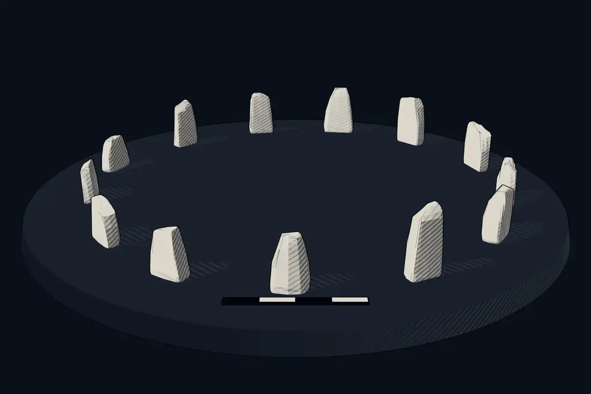
The reconstruction is ours, not a survey: it shows what a monument of this type looks like, at the size the record gives for this one.
Photographs
4 photographs, each with its author and licence
More photographs
Lore
Evidence & Lore
What the sources actually support — and, kept apart, what has been claimed.
What the evidence supports
Dates
Est. 3300–2500 BCEHow this date was established: Type comparisonTypical range for stone circles in France; this site has not been dated itself. Stone circles are typical of Brittany and most were built between 3300 and 2500 BC.Source for this date
Where it stands
France
The pin marks the monument itself — its exact point.
- Coordinates
- 47°21′40″ N, 0°25′05″ WFor a GPS or map app: 47.36110, -0.41805
Access is as our sources describe it; we have not visited the site to check.
Nearby
The closest sites in the Atlas, by straight line.


Sources
Every record behind this page, with the link it came from.
2 sources behind this page
- 01Wikidata Q3003701wikidata.org
- 02Source for this dateen.wikipedia.org
Image files
Report a correctionWrong date, name, photograph or source? Tell us and it will be put right.
Around this place
The ten nearest sites, by compass
- Dolmen de Charcé<0.1 km S
- Caillère dolmen5.2 km E
- L’Étiau dolmen5.5 km NE
- Pierre Couverte du Moulin de Piau5.7 km E
- La Bajoulière dolmen9.1 km E
- dolmens des Varennes de Cumeray11 km E
- Dolmen de la Forêt11 km E
- Pierre couverte d'Avort12 km SE
- Pierre Longue du Bouchet12 km E
- Pierre couverte de la Pagerie12 km E
Credit
Text, licence and sources
Text from the Wikipedia article "Pierre levée de Beaupreau" (French), licensed CC BY-SA 4.0; authors are listed in the page history. Reused under CC BY-SA 4.0. Read on Wikipedia · Edit history and authors