
Overview
About this site
What the sources say
Tomb KV39 in Egypt's Valley of the Kings is one of the possible locations of the tomb of Amenhotep I, a pharaoh of the Eighteenth Dynasty of Egypt. It is located high in the cliffs, away from the main valley bottom and other royal burials. It is in a small wadi that runs from the east side of Al-Qurn hill, directly under the ridge where the workmen's village of Deir el-Medina lies. The layout of the tomb is unique. It has two axes, one east and one south. Its construction seems to have occurred in three phases. It began as a simple straight axis tomb that never continued past the first room. In the subsequent phase, a series of long descending corridors and steps were cut to the east and south. It was discovered around 1900 by either Victor Loret or Macarious and Andraos but was not fully examined. It was excavated between 1989 and 1994 by John Rose and was further examined in 2002 by Ian Buckley. Based on the tomb's architecture and pottery found, it was likely cut in the early Eighteenth Dynasty, possibly for a queen. Fragmentary remains of burials were recovered from parts of the tomb but who they belong to is unknown. KV39's location may fit the description of the tomb of Amenhotep I given in the Abbott Papyrus but this is the subject of debate.
Read on Wikipedia8 min readCC BY-SA 4.0
Where it sits in time
The site's dated range, placed against world reference points.
The scale is logarithmic: each step to the left is about ten times older than the last.
The full article
KV39: the whole story
In briefSources for this section
- Wikipedia (English): KV39CC BY-SA 4.0
Sources for this section
- Wikipedia (English): KV39CC BY-SA 4.0
Tomb KV39 in Egypt's Valley of the Kings is one of the possible locations of the tomb of Amenhotep I, a pharaoh of the Eighteenth Dynasty. It lies high in the cliffs, away from the main valley bottom and other royal burials, in a small wadi on the east side of Al-Qurn hill, directly under the ridge where the workmen's village of Deir el-Medina lies. This kind of location is typical of tombs of the early Eighteenth Dynasty.
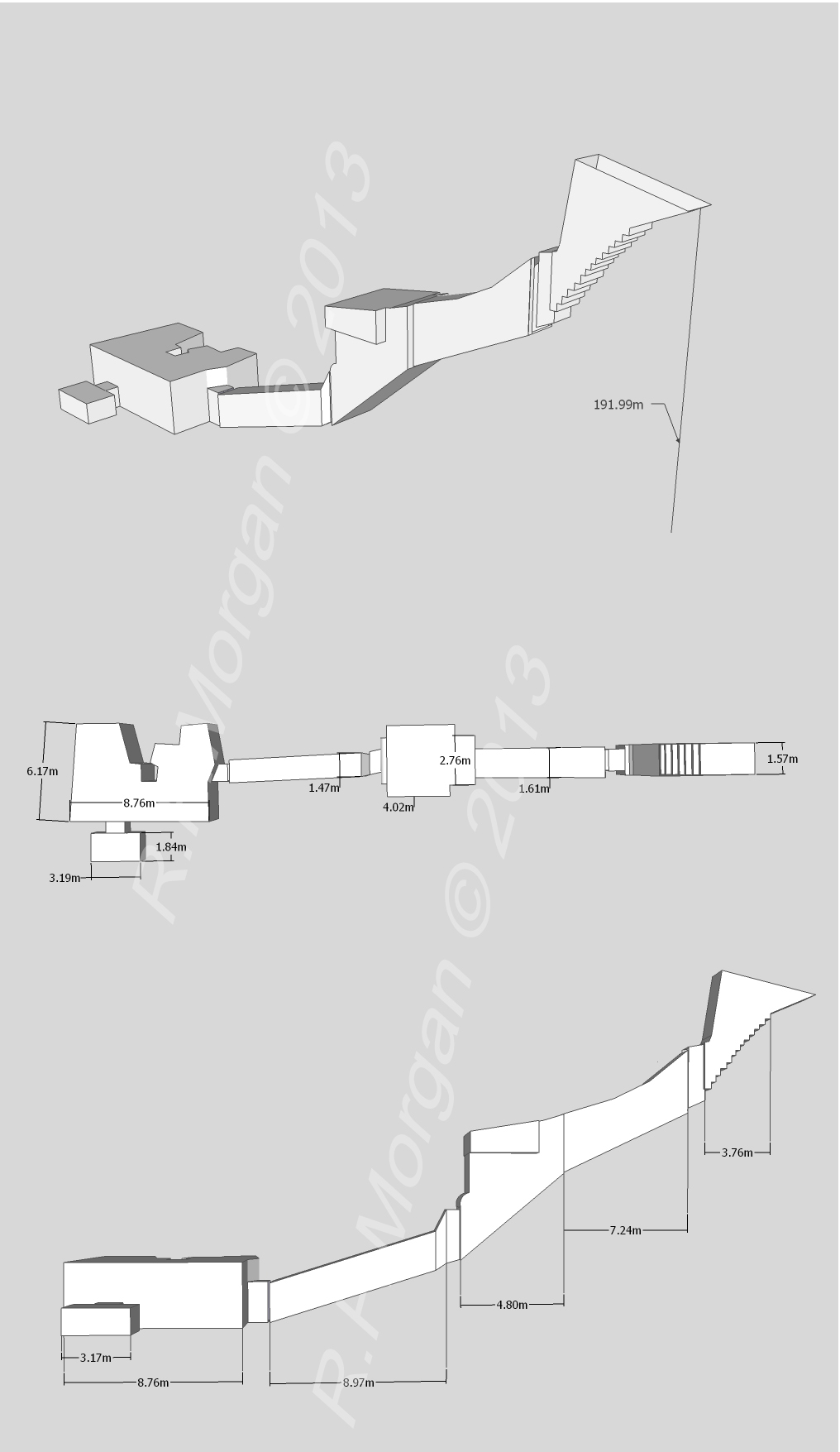
The layout is unique, with two axes, one east and one south, and seems to have been built in three phases. A steep set of stairs descends for 7 metres (23 ft) to a corridor that leads to a square hall. The neatly cut east passage extends 38.33 metres (125.8 ft) through three steeply descending corridors and two staircases to a single chamber. The southern passage, more roughly cut, descends steeply for about 25 metres (82 ft). The tomb is undecorated, though red mason's marks appear throughout.
Victor Loret, or Macarious and Andraos, discovered it in 1899 or 1900. Arthur Weigall published a description in 1911. John Rose excavated it between 1989 and 1994, finding miniature vessels bearing the cartouches of Thutmose I, Thutmose II and Amenhotep II, and Ian Buckley did more work in 2002. Fragmentary burials were recovered, with signs of a high standard of mummification, but who they belong to is unknown.
Weigall first suggested KV39 as the burial place of Amenhotep I in 1911, drawing on the Abbott Papyrus, though this is debated. The architecture suggests the tomb was probably cut for a queen of the early Eighteenth Dynasty. Rose suggested it was originally the tomb of Ahmose Inhapy and later expanded for the reburial of Amenhotep I. Sjef Willockx instead proposed that it was the original tomb of Thutmose I, before he was moved to KV20 by his daughter Hatshepsut.
SettingSources for this section
- Wikipedia (English): KV39CC BY-SA 4.0
Sources for this section
- Wikipedia (English): KV39CC BY-SA 4.0
KV39 is located to the south of the Valley of the Kings, high up at the head of a small valley above the tomb of Thutmose III, on the eastern side of Al-Qurn, the peak above the royal valley. This kind of location, high in the cliffs and placed below a dry water course, is typical of tombs of the early Eighteenth Dynasty.
ArchaeologySources for this section
- Wikipedia (English): KV39CC BY-SA 4.0
Sources for this section
- Wikipedia (English): KV39CC BY-SA 4.0
KV39 was discovered in 1899 or 1900 by the French Egyptologist Victor Loret or by the Egyptian excavators Macarious and Andraos. The tomb was visited by the Egyptologist Arthur Weigall and others, and Weigall published a description of the tomb in 1911. Elizabeth Thomas, an American Egyptologist, drew a plan of the tomb in 1966 without entering it, finding the entrance was blocked by a large boulder.
The tomb was first excavated between 1989 and 1994 by the Egyptologist John Rose. The stairs were cleared of the large rock and a large trench was dug in front of the tomb, uncovering miniature vessels placed in a pit 1 metre (3.3 ft) from the entrance. They bore the cartouches of Thutmose I, Thutmose II and Amenhotep II and represent a foundation deposit dating to the mid-Eighteenth Dynasty. A stone wall was found at the top of the stairs, presumably constructed in the early 1900s to prevent debris from refilling the tomb during clearance work; a second wall had been built inside the tomb, replacing a section of steps cut from poor quality rock.
The Egyptologist Ian Buckley conducted further excavation and survey work in the tomb in 2002. The tomb had been entered after the conclusion of Rose's work and refilled with debris washed in during the floods of 1994. The more unstable layers of rock had been affected by the water. The southern passageway was not excavated as sections of the ceiling had collapsed in addition to containing flood-washed fill. At the conclusion of the 2002 season the entrance was sealed with steel mesh and two stone walls were built to protect it from further flood action and prevent the intrusion of more debris. The tomb had evidently seen human use in the past, based on the presence of soot from fires on the ceilings of the antechamber and upper burial chamber, and the finds of rubbish such as newspapers and modern litter.
Analysis of the pottery indicate a mix of early and later Eighteenth Dynasty styles. At least part of the tomb had been used for burials. The entrance to the eastern passage showed signs of mud plaster, and large quantities of linen fabric, pottery, and fragments of coffins were found in the passageway and burial chamber. The mummified remains show evidence of a high standard of mummification, including the use of padding inserted under the skin and fine quality textile wrapping.
DescriptionSources for this section
- Wikipedia (English): KV39CC BY-SA 4.0
Sources for this section
- Wikipedia (English): KV39CC BY-SA 4.0
KV39 is entered via a steep set of stairs that descend for 7 metres (23 ft). This opens onto to a descending corridor that leads a square hall, beyond which is a rectangular chamber that is entered via a low doorway. A set of unfinished stairs are cut into the floor in this room. Two further descending passageways run from the square hall. One, known as the east passage, begins at 180 degrees to the axis of the entrance. It is neatly cut and extends 38.33 metres (125.8 ft) through three steeply descending corridors and two staircases to a single rectangular chamber. The other passageway extends to the south, at 90 degrees to the main axis. This passageway has not been fully cleared but it appears to be more roughly cut and descends steeply for a distance of about 25 metres (82 ft).
The architectural layout of the tomb seems to have been altered several times and cut in different phases. It may have started as a simple corridor tomb, or as a vertical shaft accessing a corridor and rectangular chamber. The latter form is very similar to tomb ANA at Dra' Abu el-Naga dating to the late Seventeenth or early Eighteenth Dynasty. Aston sees the southern extension to the tomb to be the second phase of construction, while Buckley and colleagues consider it the last phase and represents an unfinished annex or a cache for royal mummies. The southern passageway is very similar to TT358, tomb of Amenhotep I's sister Ahmose-Meritamun and TT320, the royal cache. Aston considers the third phase of construction to be the cutting of the east extension as it is similar in design to KV32, tomb of Thutmose IV's mother Tiaa, and presumably cut at around the same time as that tomb, during the mid-Eighteenth Dynasty in the reigns of Amenhotep II or Thutmose IV.
The tomb is undecorated but mason's marks in red paint, used to guide the cutting of the tomb, are seen throughout on the ceilings and walls. Their locations and appearance are similar to those seen in the mid-Eighteenth Dynasty tombs of Thutmose III (KV34) and Amenhotep II (KV35).
KV39 may be one of the earliest tombs in the Valley of the Kings. Its location is indicative of the early Eighteenth Dynasty, as is its east-facing entrance, is something seen in royal Theban tombs before and during the early part of the Eighteenth Dynasty. The various phases of its construction are similar to the tombs of early Eighteenth Dynasty royalty. It certainly predates the tomb of Thutmose III as it lacks a protective well chamber.
Intended occupantSources for this section
- Wikipedia (English): KV39CC BY-SA 4.0
Sources for this section
- Wikipedia (English): KV39CC BY-SA 4.0
It is unknown who the tomb was cut for but based on its architecture it was probably intended for a queen of the early Eighteenth Dynasty.
KV39 as the burial place of Amenhotep I was first suggested by Weigall in 1911. He drew on the location of that king's tomb as described in the Abbott Papyrus, as being 120 cubits (63 metres (207 ft)) from a feature called aḥay to the north of the "house of Amenhotep of the Garden". The translation of aḥay is disputed and the other landmarks are not securely identified, but Weigall identified aḥay as the way station on the high path above KV39.
Rose suggested KV39 was originally the tomb of Ahmose Inhapy and was later expanded by the cutting of the east passage for the reburial of Amenhotep I. This is based on inscriptions on the coffins of Ramesses I, Seti I, and Ramesses II which state they were moved from KV17 to the tomb of "Queen Inhapy in which Amenhotep I lay".
Sjef Willockx has suggested that KV39 was not the tomb of Amenhotep I, but rather Tomb ANB in Dra' Abu el-Naga'. Instead, he suggests that KV39 was actually the original tomb of Thutmose I before being moved to KV20 by his daughter Hatshepsut.
How this page was madeSources for this section
- Wikipedia (English): KV39CC BY-SA 4.0
Sources for this section
- Wikipedia (English): KV39CC BY-SA 4.0
The summary at the top of this page was written by Claude Sonnet 5.5 (2026-11-06) from the cited Wikipedia article “KV39”. The numbers in it were checked automatically against the source text. The rest of the page is the article itself, the structured records and computed distances.
Tradition and region
About this kind of monument
Rock-cut tombs of Egypt
Egypt has some of the best-known rock-cut tombs in the world. In the Valley of the Kings, on the west bank of the Nile opposite Thebes, tombs were excavated for pharaohs and powerful nobles of the New Kingdom, for a period of nearly 500 years from the Eighteenth to the Twentieth Dynasty. The valley has two main sections, the East Valley where most royal tombs lie and the West Valley, known as the Valley of the Monkeys, and it is known to contain 65 tombs and chambers. It gained great attention after the discovery of the tomb of Tutankhamun in 1922, and became a UNESCO World Heritage Site in 1979 with the rest of the Theban Necropolis.
Much earlier, Beni Hasan in Middle Egypt is an ancient funerary site cut into the limestone cliffs on the east bank of the Nile about 20 kilometres south of Minya. In the Middle Kingdom it was the principal cemetery of the sixteenth nome of Upper Egypt, the Oryx nome, and its monumental tombs were cut roughly halfway up the cliff, overlooking the valley. Rock-cut tombs are also found at Deir el-Medina, between the Valley of the Kings and the Valley of the Queens.
The mastaba is a different tradition: a flat-roofed rectangular tomb with sloping sides, built of mudbrick or limestone, which marked the burial sites of eminent Egyptians in the Early Dynastic Period and Old Kingdom. The mastaba was built above ground and the rock-cut tomb into the cliff.
Egyptian tombs are among the best dated monuments in the Atlas, because the dynasty or reign of the king or noble who owned them is known.
When visiting, remember that access to many tombs is limited.
Paraphrased from Wikipedia: Valley of the Kings, Wikipedia: Beni Hasan, Wikipedia: Rock-cut tomb, Wikipedia: Mastaba · CC BY-SA 4.0
From the article
Dated moments in the story
- 1899
KV39 was discovered in 1899 or 1900 by the French Egyptologist Victor Loret or by the Egyptian excavators Macarious and Andraos.
Source - 1900
It was discovered around 1900 by either Victor Loret or Macarious and Andraos but was not fully examined.
Source - 1911
The tomb was visited by the Egyptologist Arthur Weigall and others, and Weigall published a description of the tomb in 1911. Elizabeth Thomas, an American Egyptologist, drew a plan of the tomb in 1966 without entering it, finding the entrance was blocked by a large boulder.
Source - 1911
KV39 as the burial place of Amenhotep I was first suggested by Weigall in 1911. He drew on the location of that king's tomb as described in the Abbott Papyrus, as being 120 cubits (63 metres (207 ft)) from a feature called aḥay to the north of the "house of Amenhotep of the Garden".
Source - 1989
It was excavated between 1989 and 1994 by John Rose and was further examined in 2002 by Ian Buckley.
Source - 1989
The tomb was first excavated between 1989 and 1994 by the Egyptologist John Rose.
Source - 2002
The Egyptologist Ian Buckley conducted further excavation and survey work in the tomb in 2002. The tomb had been entered after the conclusion of Rose's work and refilled with debris washed in during the floods of 1994. The more unstable layers of rock had been affected by the water.
Source - 2002
At the conclusion of the 2002 season the entrance was sealed with steel mesh and two stone walls were built to protect it from further flood action and prevent the intrusion of more debris.
Source
Photographs
2 photographs, each with its author and licence
More photographs
Lore
Evidence & Lore
What the sources actually support — and, kept apart, what has been claimed.
What the evidence supports
Dates
Est. 3600–2500 BCEHow this date was established: Type comparisonTypological estimate, not a date for this site: a hypogeum in North Africa is normally dated between 3600 BCE and 2500 BCE (Atlas typological table).Source for this date
Measured facts
- Mainstream position
- The source regards KV39 as an early Eighteenth Dynasty tomb, possibly made for a queen, while the identity of its occupants remains unknown.Source: Mainstream position
- Location
- A small wadi beneath Al-Qurn hill in Egypt's Valley of the KingsSource: Location
- Layout
- Two axes, one east and one southSource: Layout
- Discovery
- Around 1899 or 1900Source: Discovery
- Major excavation
- 1989 to 1994Source: Major excavation
- Foundation deposit
- Miniature vessels bearing cartouches of Thutmose I, Thutmose II, and Amenhotep IISource: Foundation deposit
- Burial remains
- Fragmentary remains whose owners are unknownSource: Burial remains
- Culture
- Ancient EgyptSource: Culture
- Length
- 101.09 metreSource: Length
Alternative claims
Alternative claims about this site, kept in their own block and labelled with where they stand.
KV39 matches the description of Amenhotep I's tomb in the Abbott Papyrus.
DebatedSource for this claim: KV39 matches the description of Amenhotep I's tomb in the Abbott Papyrus.
Where it stands
Egypt
The pin marks the monument itself — its exact point.
- Coordinates
- 25°44′16″ N, 32°36′06″ EFor a GPS or map app: 25.73778, 32.60167
Access is as our sources describe it; we have not visited the site to check.
Nearby
The closest sites in the Atlas, by straight line.




Sources
Every record behind this page, with the link it came from.
2 sources behind this page
- 01Wikidata Q1597218wikidata.org
- 02Wikipedia (en)en.wikipedia.org
Image files
- KV39 Amenhotep I.jpgR.F.MorganCC BY-SA 3.0
- KV39Plan.pngHotepibreCC BY-SA 4.0
Report a correctionWrong date, name, photograph or source? Tell us and it will be put right.
Lore, kept apart
Legends and claims
These are stories and claims reported by the sources. They are not evidence, and they never stand in for the dating above.
- Tested: not supported
KV39 matches the description of Amenhotep I's tomb in the Abbott Papyrus.
Source
Around this place
The ten nearest sites, by compass
Credit
Text, licence and sources
Text from the Wikipedia article "KV39" (English), licensed CC BY-SA 4.0; authors are listed in the page history. Reused under CC BY-SA 4.0. Read on Wikipedia · Edit history and authors
- Wikipedia (English): KV39CC BY-SA 4.0
- Wikidata Q1597218CC0