_-_2025-12-10_-_34.jpg/1920px-Vall%C3%A9e_Rois_-_Louxor_(EG)_-_2025-12-10_-_34.jpg 1920w)
Overview
About this site
Overview
KV31 is an ancient Egyptian rock-cut tomb in the Valley of the Kings, near Luxor, Egypt. Only the top of its shaft was known before excavation by the University of Basel Kings' Valley Project in 2010. The tomb was found filled with mixed debris of pottery shards and linen fragments, together with the remains of five mummified elite individuals dating to the Eighteenth Dynasty.
Read on Wikipedia4 min readCC BY-SA 4.0
Where it sits in time
The site's dated range, placed against world reference points.
The scale is logarithmic: each step to the left is about ten times older than the last.
Article
KV31
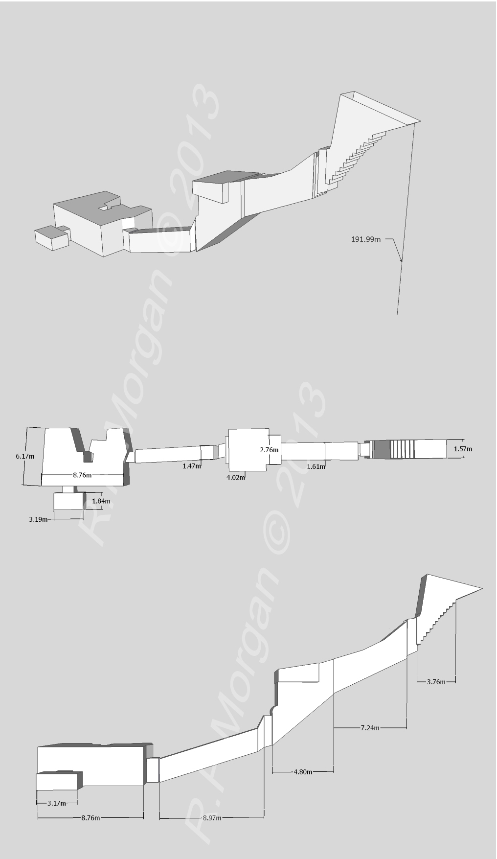
The tomb consists of a vertical shaft that leads to a chamber with two further rooms opening from it.
DescriptionSources for this section
- Wikipedia (English): KV31CC BY-SA 4.0
Sources for this section
- Wikipedia (English): KV31CC BY-SA 4.0
The tomb consists of a vertical shaft that leads to a chamber with two further rooms opening from it. Most of the tomb is cut from good quality limestone bedrock; the first chamber is partly cut from bedrock and partly from conglomerate. The shaft is well cut and descends 5 metres (16 ft) through accumulated conglomerate and bedrock.
ExcavationsSources for this section
- Wikipedia (English): KV31CC BY-SA 4.0
Sources for this section
- Wikipedia (English): KV31CC BY-SA 4.0
The tomb was likely one of two, the other being KV30, excavated in 1817 by Giovanni Battista Belzoni on behalf of the Second Earl Belmore. If this is correct, it may be the place of origin of a stone sarcophagus donated by Belmore to the British Museum. It was numbered by Victor Loret in 1898, but no excavation is known.
In January 2010 the University of Basel Kings' Valley Project began excavating the tomb. The fill within the shaft contained modern rubbish above limestone chips, sand and rocky debris, and three pots containing Nile mud used for sealing the door of the tomb were found at the bottom. The main chamber and its two adjoining rooms were filled with debris to a depth of at least 1 metre (3.3 ft). The tomb had clearly been thoroughly robbed in the past, as pieces of broken funerary items were scattered around. A metal door was installed over the shaft at the end of the excavation to protect the tomb, and it was mapped in the 2010 and 2011 seasons.
FindsSources for this section
- Wikipedia (English): KV31CC BY-SA 4.0
Sources for this section
- Wikipedia (English): KV31CC BY-SA 4.0
The fill in all the rooms contained the same mix of broken pottery from white-washed and decorated jars, wooden fragments of coffins, large quantities of linen bandages, natron bags and other textiles, and the unwrapped remains of mummies. Fragments of two canopic jars were found, one of calcite and one of limestone; the latter was inscribed but the space for the owner's name was blank. A piece of a dummy jar inscribed for Sennefer was also found. Organic materials, including wood and fabric, were in excellent condition. The tomb likely dates to the reigns of Thutmose III and Amenhotep II during the mid-Eighteenth Dynasty. Later finds include ostraca, a piece of linen embroidered with the cartouche of Ramesses III, and an ushabti of the Twentieth Dynasty.
The two side chambers held five mummies, two women and three men, all between the ages of 18 and 30. Having no names, they were designated by the room in which they were found (room C or room D). The unwrapping and scattering of the bodies was likely the work of tomb robbers, both ancient and modern: the mummies were likely unwrapped during the Third Intermediate Period, while the removal of heads and hands is attributed to more modern robbers looking for pieces to sell to early tourists. Given the large quantity of pottery, the report suggests that all five were originally interred together, and their style of mummification conforms to that seen in the elites of the mid-Eighteenth Dynasty.
Mummy C1 is female and was 18–25 years old at death; her body is 159–160 centimetres (5.22–5.25 ft) long. Mummy C2 is likely a young male aged 20–25 years, with a body measuring 159 centimetres (5.22 ft) and braided hair at the back of the head. Mummy C3 is likely male, headless, with the arms crossed over the chest and the fingers of the left hand clenched, in the manner of a king; he is estimated to have been 18–25 years old, with a height in life of 175 centimetres (5.74 ft). Mummy C4 is the largely intact body of an individual who is possibly male, 154 centimetres (5.05 ft) long, with short hair save for longer strands on the right side, suggesting the side-lock of youth; the embalming incision may be vertical, which possibly dates the mummy to before the reign of Thutmose III. Mummy D1 is the highly fragmented body of an adult aged 20–30 years, possibly female, although this is uncertain.
Tradition and region
About this kind of monument
Rock-cut tombs of Egypt
Egypt has some of the best-known rock-cut tombs in the world. In the Valley of the Kings, on the west bank of the Nile opposite Thebes, tombs were excavated for pharaohs and powerful nobles of the New Kingdom, for a period of nearly 500 years from the Eighteenth to the Twentieth Dynasty. The valley has two main sections, the East Valley where most royal tombs lie and the West Valley, known as the Valley of the Monkeys, and it is known to contain 65 tombs and chambers. It gained great attention after the discovery of the tomb of Tutankhamun in 1922, and became a UNESCO World Heritage Site in 1979 with the rest of the Theban Necropolis.
Much earlier, Beni Hasan in Middle Egypt is an ancient funerary site cut into the limestone cliffs on the east bank of the Nile about 20 kilometres south of Minya. In the Middle Kingdom it was the principal cemetery of the sixteenth nome of Upper Egypt, the Oryx nome, and its monumental tombs were cut roughly halfway up the cliff, overlooking the valley. Rock-cut tombs are also found at Deir el-Medina, between the Valley of the Kings and the Valley of the Queens.
The mastaba is a different tradition: a flat-roofed rectangular tomb with sloping sides, built of mudbrick or limestone, which marked the burial sites of eminent Egyptians in the Early Dynastic Period and Old Kingdom. The mastaba was built above ground and the rock-cut tomb into the cliff.
Egyptian tombs are among the best dated monuments in the Atlas, because the dynasty or reign of the king or noble who owned them is known.
When visiting, remember that access to many tombs is limited.
Paraphrased from Wikipedia: Valley of the Kings, Wikipedia: Beni Hasan, Wikipedia: Rock-cut tomb, Wikipedia: Mastaba · CC BY-SA 4.0
From the article
Dated moments in the story
- 1817
The tomb was likely one of two (the other being KV30) tombs excavated in 1817 by Giovanni Battista Belzoni on behalf of Second Earl Belmore.
Source - 1898
It was numbered by Victor Loret in 1898 but no excavation is known.
Source - 2010
Only the top of the shaft was known prior to excavation by the University of Basel Kings' Valley Project in 2010, and no earlier excavations are known, although it is suggested that the stone sarcophagus excavated by Giovanni Battista Belzoni in 1817 may have originated from this tomb.
Source - 2010
In January 2010 the University of Basel Kings' Valley Project began their excavation of the tomb, of which only the upper portion of the shaft was known.
Source - 2010
The tomb was mapped in the 2010 and 2011 seasons.
Source
Photographs
2 photographs, each with its author and licence
More photographs
Lore
Evidence & Lore
What the sources actually support — and, kept apart, what has been claimed.
What the evidence supports
Dates
Est. 1539–1075 BCEHow this date was established: Type comparisonTypical range for hypogeums in Egypt; this site has not been dated itself. The Valley was used for primary burials from approximately 1539 BC to 1075 BC.Source for this date
Where it stands
Egypt
The pin marks the monument itself — its exact point.
- Coordinates
- 25°44′19″ N, 32°36′03″ EFor a GPS or map app: 25.73860, 32.60080
Access is as our sources describe it; we have not visited the site to check.
Nearby
The closest sites in the Atlas, by straight line.


Sources
Every record behind this page, with the link it came from.
3 sources behind this page
- 01Wikidata Q591371wikidata.org
- 02Source for this dateen.wikipedia.org
- 03Wikipedia: KV31en.wikipedia.org
Image files
Report a correctionWrong date, name, photograph or source? Tell us and it will be put right.
Around this place
The ten nearest sites, by compass
Credit
Text, licence and sources
Adapted from the Wikipedia article "KV31" (English), licensed CC BY-SA 4.0; authors are listed in the page history. Reused under CC BY-SA 4.0. Read on Wikipedia · Edit history and authors
- Wikipedia (English): KV31CC BY-SA 4.0
- Wikidata Q591371CC0