Overview
About this site
What the sources say
Tomb KV30 is an ancient Egyptian tomb located in the Valley of the Kings in Egypt. It likely dates to the mid-Eighteenth Dynasty and was used for the burial of an unknown individual. It may have been discovered by Giovanni Belzoni in 1817, working on a commission from the 2nd Earl Belmore. It was excavated between 2009 and 2010 by the University of Basel's Kings' Valley Project.
Read on Wikipedia5 min readCC BY-SA 4.0
Where it sits in time
The site's dated range, placed against world reference points.
The scale is logarithmic: each step to the left is about ten times older than the last.
The full article
KV30: the whole story
In briefSources for this section
- Wikipedia (English): KV30CC BY-SA 4.0
Sources for this section
- Wikipedia (English): KV30CC BY-SA 4.0
Tomb KV30 is an ancient Egyptian tomb in the Valley of the Kings in Egypt. It likely dates to the mid-Eighteenth Dynasty and was used for the burial of an unknown individual. It lies in a side valley that leads to the tomb of Thutmose III (KV34), among other tombs of similar date, including the tomb of Thutmose IV's mother Tiaa (KV32) and KV42. It is approximately opposite KV26.
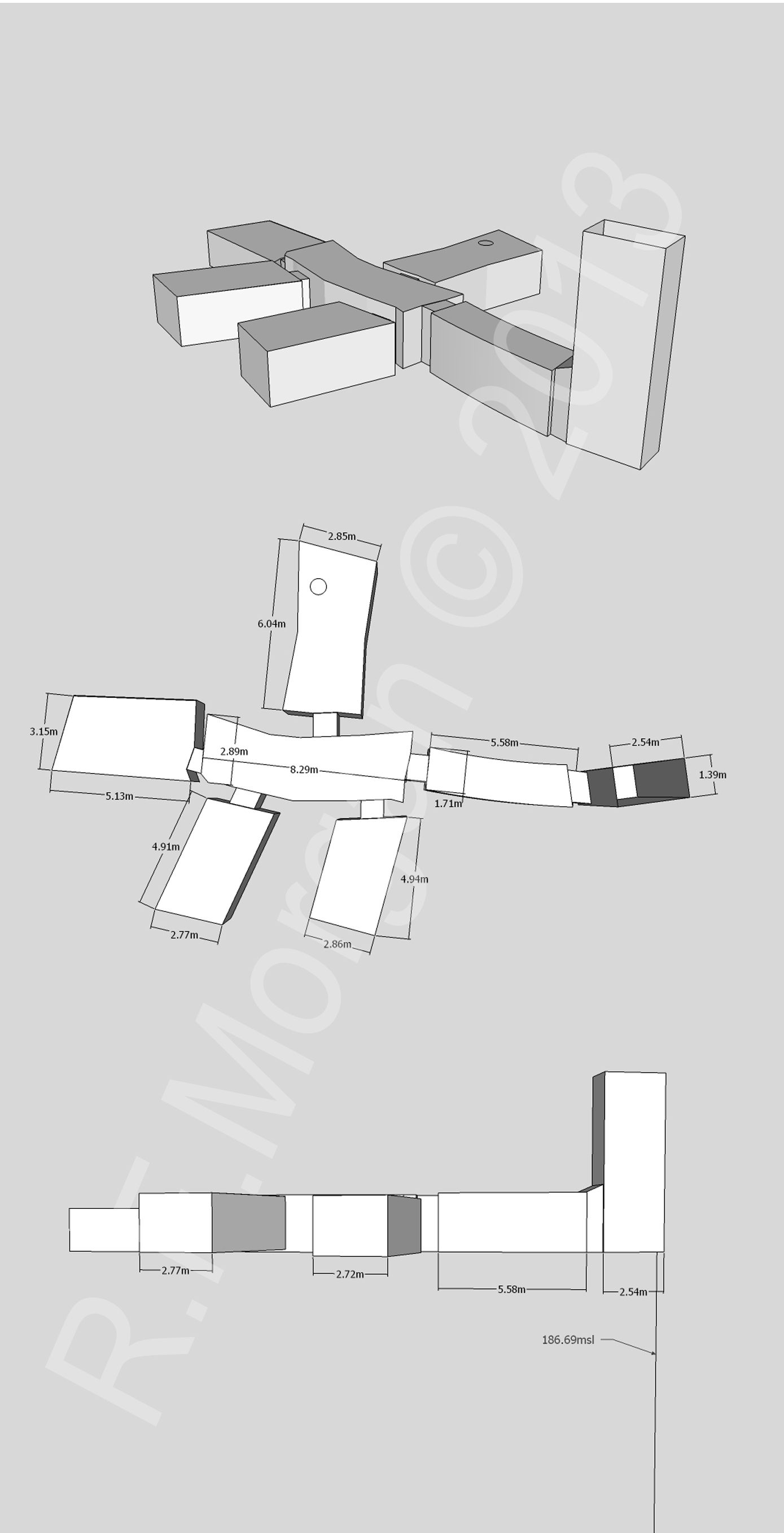
The layout consists of a vertical shaft 7 metres (23 ft) deep, which opens onto a corridor leading to one large chamber surrounded by four smaller rooms. The tomb has a total length of 23 metres (75 ft). Red ink outlines of the intended door widths for all the side chambers show that construction marks remain in the tomb.
Its modern history is uncertain. In the 1960s Elizabeth Thomas suggested that it was one of the two tombs excavated by Giovanni Belzoni for Lord Belmore, and so might be where the sarcophagus came from that Lord Belmore donated to the British Museum. The early Egyptologist James Burton visited it in the early 1800s and noted a red ink inscription, theorised to be a quarry mark. Thomas made a map in the 1960s and mentioned a single Eighteenth Dynasty pot sherd, and the Theban Mapping Project mapped the tomb again in the 1980s.
The University of Basel's Kings' Valley Project excavated the tomb in 2009. The shaft held modern rubbish above older sandy fill, and a large boulder filled almost the entire shaft. Beneath it were a wooden docket for fat and pottery, one sherd of which refit with a vessel from KV26. The red ink inscription noted by Burton was found in the shaft, approximately 1.70 metres (5.6 ft) above the floor, and proved to be a graffito made of components of the name Menkheperre, the throne name of Thutmose III, although its exact reading is unclear.
The corridor was filled to within 50 centimetres (20 in) of the ceiling. The mixed fill held reed matting, fragments of painted wooden coffins, ostraca, faience, a piece of coloured glass and cartonnage, which indicates a burial presumably in the Eighteenth Dynasty. The main chamber was only partly filled with debris, including pieces of wooden and stone vessels, and its far side was filled with bat droppings. The tomb was re-cleared, a protective door was fitted to the entrance, and it was accurately mapped in 2010 and comprehensively photographed in 2016.
SettingSources for this section
- Wikipedia (English): KV30CC BY-SA 4.0
Sources for this section
- Wikipedia (English): KV30CC BY-SA 4.0
KV30 is located in a side valley that leads to the tomb of Thutmose III (KV34) and other tombs of similar date including the tomb of Thutmose IV's mother Tiaa (KV32) and KV42. It is approximately opposite KV26.
The layout consists of a vertical shaft 7 metres (23 ft) deep which opens onto a corridor that leads to one large chamber surrounded by four smaller rooms. It has a total length of 23 metres (75 ft).
ArchaeologySources for this section
- Wikipedia (English): KV30CC BY-SA 4.0
Sources for this section
- Wikipedia (English): KV30CC BY-SA 4.0
The modern history of this tomb is uncertain. In the 1960s Elizabeth Thomas suggested this tomb was one of the two excavated by Giovanni Belzoni for Lord Belmore, and consequently may be the source of the sarcophagus that Lord Belmore donated to the British Museum. The early Egyptologist James Burton visited the tomb in the early 1800s and noted a red ink inscription, theorised to be a quarry mark. In the 1960s Thomas produced a map of the tomb and mentioned it contained a single Eighteenth Dynasty pot sherd. The tomb was later mapped in the 1980s by the Theban Mapping Project.
The tomb was excavated in 2009 by the University of Basel's Kings' Valley Project. The open shaft contained modern rubbish above older sandy fill. A large boulder filled almost the entire shaft; below it was a wooden docket for fat, and pottery, one sherd of which refit with a vessel from KV26. Two wooden beams and the remains of matting were sitting on top of the fill. The red ink inscription mentioned by Burton was located in the shaft, approximately 1.70 metres (5.6 ft) above the floor, and proved to be a graffito consisting of components of the name Menkheperre (throne name of Thutmose III) although its exact reading is unclear.
The corridor was filled to within 50 centimetres (20 in) of the ceiling. The tomb was used for a burial, presumably in the Eighteenth Dynasty, as within the mixed fill was reed matting, fragments of painted wooden coffins, ostraca, faience, a piece of coloured glass, and cartonnage. The main chamber was only partly filled with debris that included pieces of wooden and stone vessels. The single piece of pottery, the base of a jar, mentioned by Thomas was still present. The far side of the chamber was filled with bat droppings but otherwise clear. The tomb did contain construction marks in the form of red ink outlines of the intended door widths for all the side chambers. The tomb was re-cleared and protective door was fitted to the entrance; it was accurately mapped in 2010 and comprehensively photographed in 2016.
How this page was madeSources for this section
- Wikipedia (English): KV30CC BY-SA 4.0
Sources for this section
- Wikipedia (English): KV30CC BY-SA 4.0
The summary at the top of this page was written by Claude Sonnet 5.5 (2026-11-06) from the cited Wikipedia article “KV30”. The numbers in it were checked automatically against the source text. The rest of the page is the article itself, the structured records and computed distances.
Tradition and region
About this kind of monument
Rock-cut tombs of Egypt
Egypt has some of the best-known rock-cut tombs in the world. In the Valley of the Kings, on the west bank of the Nile opposite Thebes, tombs were excavated for pharaohs and powerful nobles of the New Kingdom, for a period of nearly 500 years from the Eighteenth to the Twentieth Dynasty. The valley has two main sections, the East Valley where most royal tombs lie and the West Valley, known as the Valley of the Monkeys, and it is known to contain 65 tombs and chambers. It gained great attention after the discovery of the tomb of Tutankhamun in 1922, and became a UNESCO World Heritage Site in 1979 with the rest of the Theban Necropolis.
Much earlier, Beni Hasan in Middle Egypt is an ancient funerary site cut into the limestone cliffs on the east bank of the Nile about 20 kilometres south of Minya. In the Middle Kingdom it was the principal cemetery of the sixteenth nome of Upper Egypt, the Oryx nome, and its monumental tombs were cut roughly halfway up the cliff, overlooking the valley. Rock-cut tombs are also found at Deir el-Medina, between the Valley of the Kings and the Valley of the Queens.
The mastaba is a different tradition: a flat-roofed rectangular tomb with sloping sides, built of mudbrick or limestone, which marked the burial sites of eminent Egyptians in the Early Dynastic Period and Old Kingdom. The mastaba was built above ground and the rock-cut tomb into the cliff.
Egyptian tombs are among the best dated monuments in the Atlas, because the dynasty or reign of the king or noble who owned them is known.
When visiting, remember that access to many tombs is limited.
Paraphrased from Wikipedia: Valley of the Kings, Wikipedia: Beni Hasan, Wikipedia: Rock-cut tomb, Wikipedia: Mastaba · CC BY-SA 4.0
From the article
Dated moments in the story
- 1817
It may have been discovered by Giovanni Belzoni in 1817, working on a commission from the 2nd Earl Belmore.
Source - 2009
It was excavated between 2009 and 2010 by the University of Basel's Kings' Valley Project.
Source - 2009
The tomb was excavated in 2009 by the University of Basel's Kings' Valley Project.
Source - 2010
The tomb was re-cleared and protective door was fitted to the entrance; it was accurately mapped in 2010 and comprehensively photographed in 2016.
Source
Photographs
1 photograph, each with its author and licence
Lore
Evidence & Lore
What the sources actually support — and, kept apart, what has been claimed.
What the evidence supports
Dates
Est. 3600–2500 BCEHow this date was established: Type comparisonTypological estimate, not a date for this site: a hypogeum in North Africa is normally dated between 3600 BCE and 2500 BCE (Atlas typological table).Source for this date
Measured facts
- Burial
- An unknown individualSource: Burial
- Proposed discoverer
- Giovanni Belzoni in 1817Source: Proposed discoverer
- Excavation
- University of Basel's Kings' Valley Project in 2009 and 2010Source: Excavation
- Graffito
- Components of the name MenkheperreSource: Graffito
- Burial evidence
- Reed matting and fragments of painted wooden coffinsSource: Burial evidence
- Documentation
- Mapped in 2010 and comprehensively photographed in 2016Source: Documentation
- Culture
- Ancient EgyptSource: Culture
- Length
- 42.06 metreSource: Length
Where it stands
Egypt
The pin marks the monument itself — its exact point.
- Coordinates
- 25°44′27″ N, 32°36′08″ EFor a GPS or map app: 25.74083, 32.60222
Access is as our sources describe it; we have not visited the site to check.
Nearby
The closest sites in the Atlas, by straight line.


Sources
Every record behind this page, with the link it came from.
2 sources behind this page
- 01Wikidata Q1364533wikidata.org
- 02Wikipedia (en)en.wikipedia.org
Image files
- KV30.jpgR.F.MorganCC BY-SA 3.0
Report a correctionWrong date, name, photograph or source? Tell us and it will be put right.
Around this place
The ten nearest sites, by compass
Credit
Text, licence and sources
Text from the Wikipedia article "KV30" (English), licensed CC BY-SA 4.0; authors are listed in the page history. Reused under CC BY-SA 4.0. Read on Wikipedia · Edit history and authors
- Wikipedia (English): KV30CC BY-SA 4.0
- Wikidata Q1364533CC0