
Qizkapan
Also known asQizqapan · Qyzqapan
Photo Ara Qadir · CC BY-SA 3.0Source file on Wikimedia Commons
Overview
About this site
Overview
Qizkapan (also written Qizqapan or Qyzqapan; Kurdish: Ashkawt-i Qizqapan) is a rock-cut tomb in Iraqi Kurdistan, Iraq, near the Palaeolithic cave of Zarzi. The monument is classed as a hypogeum.
It has three burial chambers, and its construction is generally attributed to the Medes.
Read on Wikipedia2 min readCC BY-SA 4.0
Article
Qizkapan
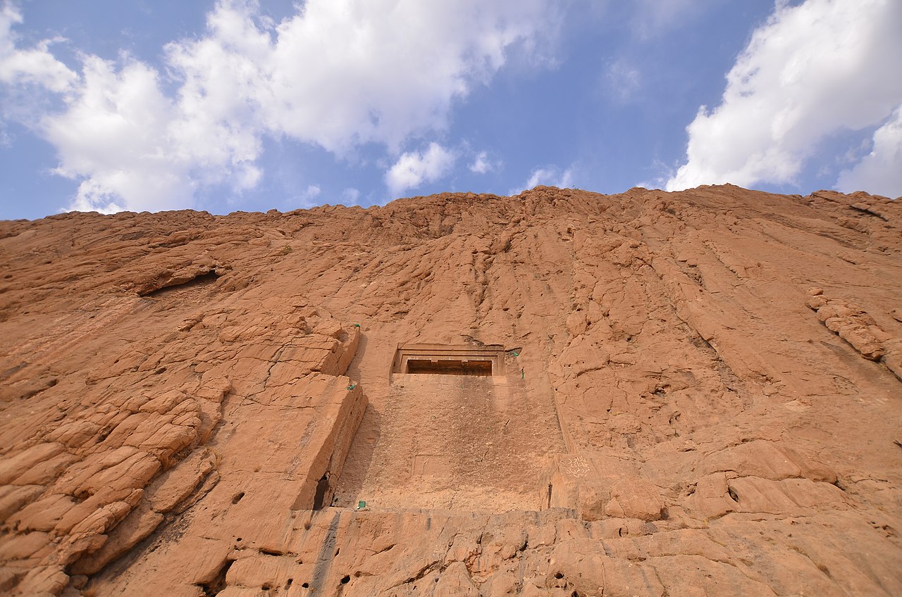
The tomb has three burial chambers, each with a hewn grave in the left corner, all accessible from a central chamber.
DescriptionSources for this section
- Wikipedia (English): QyzqapanCC BY-SA 4.0
Sources for this section
- Wikipedia (English): QyzqapanCC BY-SA 4.0
The tomb has three burial chambers, each with a hewn grave in the left corner, all accessible from a central chamber. The entrance lies approximately 8 meters above ground level.
DatingSources for this section
- Wikipedia (English): QyzqapanCC BY-SA 4.0
Sources for this section
- Wikipedia (English): QyzqapanCC BY-SA 4.0
Different dates from the Medes, Achaemenid, Seleucid and Parthian periods have been proposed for the construction of the tomb. The general belief of scientists is that it was built by the Medes. The symbols of the tomb are said to refer to Mithraism, with Mithra regarded as the supreme deity of the Medes. Some scholars, among them Igor Diakonov, believe that the tomb was built for the Median ruler Huvaxshatra, or Cyaxares, and it is considered very likely that the tomb is a royal one.
NameSources for this section
- Wikipedia (English): QyzqapanCC BY-SA 4.0
Sources for this section
- Wikipedia (English): QyzqapanCC BY-SA 4.0
Ashkawt means cave in Sorani Kurdish. The cave is also known as the cave of the abducted girl.
ContextSources for this section
- Wikipedia (English): QyzqapanCC BY-SA 4.0
Sources for this section
- Wikipedia (English): QyzqapanCC BY-SA 4.0
A rock-cut tomb is a burial chamber cut into a naturally occurring rock formation, usually into a cliff or sloping rock face, and it was a common burial form for the wealthy in ancient times in several parts of the world. A hypogeum is a subterranean temple or tomb that often has niches for cremated remains or loculi for buried ones.
Tradition and region
About this kind of monument
Rock-cut tombs of Anatolia and Iran
A rock-cut tomb is a burial chamber cut into a naturally occurring rock formation, usually into a cliff or sloping rock face, though it may also go downward in flat ground. It was a common burial form for the wealthy in ancient times in several parts of the world. A hypogeum, literally "underground", is a subterranean temple or tomb that often has niches for cremated remains or loculi for buried ones.
Important clusters are found in Iran and Turkey. At Naqsh-e Rostam, about 13 kilometres north-west of Persepolis in Fars province, the cliff face holds the tombs of four Achaemenid kings, notably Darius the Great and his son Xerxes, and a series of rock reliefs cut over more than a millennium from the Elamites and Achaemenids to the Sasanians. Other notable clusters are at Myra in Lycia, in south-west Turkey, at Petra in Jordan, where the Nabataeans cut tombs, and in ancient Israel.
The tombs of kings can be dated through the rulers they name, but an uninscribed rock-cut chamber in the countryside can only be assigned a broad range, since a cut chamber holds no material that can be dated by itself.
Folklore: the name Naqsh-e Rostam means "mural of Rostam", after the legendary hero of Iranian tradition, though the reliefs are the work of Elamite, Achaemenid and Sasanian kings.
When visiting, look at the façades and the position of the tombs high on the rock face.
Paraphrased from Wikipedia: Rock-cut tomb, Wikipedia: Hypogeum, Wikipedia: Naqsh-e Rustam · CC BY-SA 4.0
Photographs
4 photographs, each with its author and licence
More photographs
Where it stands
Iraq
The pin marks the monument itself — its exact point.
- Coordinates
- 35°48′36″ N, 45°00′25″ EFor a GPS or map app: 35.80993, 45.00685
Access is as our sources describe it; we have not visited the site to check.
Nearby
The closest sites in the Atlas, by straight line.




Sources
Every record behind this page, with the link it came from.
2 sources behind this page
- 01Wikidata Q3412496wikidata.org
- 02Wikipedia: Qizkapanen.wikipedia.org
Image files
- Qizqapan Cave.jpgAra QadirCC BY-SA 3.0
- 1. Detail. The facade of the rock-cut tombs of Qizqapan, Sulaymaniyah Governorate, Iraqi Kurdistan. Probably Achaemenid (6th-5th century BCE) rather than Median.jpgOsama Shukir Muhammed Amin FRCP(Glasg)CC BY-SA 4.0
- 10. Detail. The facade of the rock-cut tombs of Qizqapan, Sulaymaniyah Governorate, Iraqi Kurdistan. Probably Achaemenid (6th-5th century BCE) rather than Median.jpgOsama Shukir Muhammed Amin FRCP(Glasg)CC BY-SA 4.0
- 28. Detail. Entrance into the rock-cut tombs of Qizqapan, Sulaymaniyah Governorate, Iraqi Kurdistan. Probably Achaemenid (6th-5th century BCE) rather than Median.jpgOsama Shukir Muhammed Amin FRCP(Glasg)CC BY-SA 4.0
Report a correctionWrong date, name, photograph or source? Tell us and it will be put right.
Around this place
The ten nearest sites, by compass
Credit
Text, licence and sources
Adapted from the Wikipedia article "Qyzqapan" (English), licensed CC BY-SA 4.0; authors are listed in the page history. Reused under CC BY-SA 4.0. Read on Wikipedia · Edit history and authors
- Wikipedia (English): QyzqapanCC BY-SA 4.0
- Wikidata Q3412496CC0