
MegalithFringe site
Hatra
Datedc. 300 BCE–300 CE
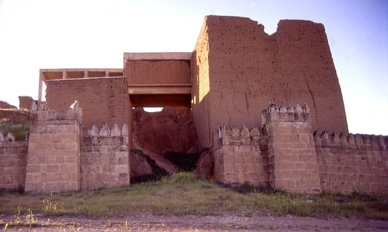
Photo Staff Sgt. JoAnn Makinano · Public domainSource file on Wikimedia Commons
Overview
About this site
What the sources say
Hatra (; Arabic: الحَضْر (Arabic pronunciation: [al.ˈħadˤr]); Syriac: ܚܛܪܐ) was an ancient city in Upper Mesopotamia located in present-day eastern Nineveh Governorate in northern Iraq. The ruins of the city lie 290 km (180 mi) northwest of Baghdad and 110 km (68 mi) southwest of Mosul. It was a strongly fortified caravan city and capital of the Arab Kingdom of Hatra, located between the Roman and Parthian/Sasanian Empires.
Hatra flourished in the 2nd century AD, and was destroyed by the Sassanid Empire and deserted in the 3rd century AD alongside other Neo-Assyrian populated states such as Assur, Adiabene, Osroene and Beth Nuhadra. Its ruins were discovered in the 19th century. It is considered the richest archaeological site from the Parthian Empire known to date. The first of the Hatran inscriptions was discovered in 1937.
Read on Wikipedia9 min readCC BY-SA 4.0
Age sources
How old this site is, and who says so.
Range across all claimsc. 300 BCE–300 CE
MeasuredWhat this badge means
A physical measurement of this site: a radiocarbon date, a tree-ring count, a luminescence date, or a record that can itself be dated.
- 200–300 CEHistorical recordThe range reflects the city's flourishing and destruction as described in the source.Source: en.wikipedia.org
- 300–101 BCEWikipedia: Hatra (infobox)Source: en.wikipedia.org
Where it sits in time
The site's dated range, placed against world reference points.
The scale is logarithmic: each step to the left is about ten times older than the last.
The full article
Hatra: the whole story
In briefSources for this section
- Wikipedia (English): HatraCC BY-SA 4.0
Sources for this section
- Wikipedia (English): HatraCC BY-SA 4.0
Hatra was an ancient city in Upper Mesopotamia, in present-day eastern Nineveh Governorate in northern Iraq. Its ruins lie 290 km (180 mi) northwest of Baghdad and 110 km (68 mi) southwest of Mosul. It was a strongly fortified caravan city and the capital of the Arab Kingdom of Hatra, located between the Roman and Parthian/Sasanian Empires. It is considered the richest archaeological site from the Parthian Empire known to date.
Nothing is known archaeologically about the city before the Parthian period, but its foundation is believed to date to the 3rd or 2nd century BCE under the Seleucid Kingdom. It flourished because of its strategic position along caravan trade routes in the 1st and 2nd centuries CE, as the capital of a semi-autonomous kingdom under Parthian influence, governed by Arabian princes. It became a buffer kingdom between the western limits of the Parthian Empire and the eastern limits of the Roman Empire.
Hatra played an important role in the Second Parthian War, withstanding repeated attacks by the Roman Empire. During the 2nd century AD the city repulsed sieges by both Trajan (116/117) and Septimius Severus (198/199). Its forces defeated the ascendant Sassanid Persians in 238, but the city fell in 241 to the army of the Sassanid king Shapur I and was destroyed. Traditional stories tell of al-Nadirah, daughter of the king, who betrayed the city to Shapur because she fell in love with him.
The plan was circular, encircled by inner and outer walls nearly 2 kilometres (1.2 mi) in diameter and supported by more than 160 towers. A temenos surrounded the principal sacred buildings at the centre; the temples covered some 1.2 hectares and were dominated by the Great Temple, an enormous structure with vaults and columns that once rose to 30 metres. The city was famed for its fusion of Greek, Assyrian, Canaanite, Aramean and Arabian pantheons, with temples to Nergal, Hermes, Atargatis, Allat, Shamiyyah and Shamash.
The site was first surveyed by Walter Andrae between 1906 and 1911, and systematic excavations have been undertaken only from 1951 by Iraqi archeologists. It has been a UNESCO World Heritage Site since 1985. Forces of the Islamic State occupied the area in mid-2014 and in early 2015 announced their intention to destroy artifacts there, making them a major threat to the site.
NameSources for this section
- Wikipedia (English): HatraCC BY-SA 4.0
Sources for this section
- Wikipedia (English): HatraCC BY-SA 4.0
Hatra is known as al-Ḥaḍr (الحضر) in Arabic. It is recorded as 𐣧𐣨𐣣𐣠 (ḥṭrʾ, vocalized as: Ḥaṭrāʾ) in Hatran inscriptions, probably meaning "enclosure, hedge, fence". In Syriac, it is usually recorded in the plural form Ḥaṭrē. In Roman works, it is recorded as Greek Átra and Latin Hatra and Hatris.
The temple of the local Assyrian god Shamash, was officially called Beit ʾElāhāʾ 𐣡𐣩𐣵 𐣠𐣫𐣤𐣠 "House of God", in Mesopotamian Aramaic inscriptions The city was recorded as "Enclosure of Shamash" (ḥtrʾ d-šmš 𐣧𐣨𐣣𐣠 𐣣𐣴𐣬𐣴) on a coin.
History and datingSources for this section
- Wikipedia (English): HatraCC BY-SA 4.0
Sources for this section
- Wikipedia (English): HatraCC BY-SA 4.0
There is no archeological information on the city before the Parthian period but settlement in the area likely dates back to at least the Seleucid period. The foundation of Hatra is believed to date to the 3rd or 2nd century BCE under the Seleucid Kingdom, It flourished because of its strategic position along caravan trade routes in the 1st and 2nd centuries CE as the capital of the Kingdom of Araba (Hatra) a semi-autonomous kingdom under the Parthian influence. The city became the capital in the chain of largely Arab-controlled cities running from Hatra, in the northeast, via Palmyra, Baalbek and Petra, in the southwest. The Kingdom of Hatra, became a buffer kingdom between the western limits of the Parthian Empire and the eastern limits of the Roman Empire, while being governed by Arabian princes.
Hatra became an important fortified frontier city and played an important role in the Second Parthian War, withstanding repeated attacks by the Roman Empire. During the 2nd century AD, the city repulsed sieges by both Trajan (116/117) and Septimius Severus (198/199). Hatra's forces defeated the ascendant Sassanid Persians in 238 at the battle of Shahrazoor, but fell shortly after in 241 to the army of Sassanid king Shapur I and was destroyed. The traditional stories of the fall of Hatra tell of al-Nadirah, daughter of the king of Araba, who betrayed the city into the hands of Shapur as she fell in love with him. The story tells of how Shapur killed the king and married al-Nadirah, but later had her killed also after realizing her ingratitude towards her father.
Hatra was the best preserved and most informative example of ancient Arabian architecture. Its plan was circular, and was encircled by inner and outer walls nearly 2 kilometres (1.2 mi) in diameter and supported by more than 160 towers.
Religion
A temenos (τέμενος) surrounded the principal sacred buildings in the city's centre. The temples covered some 1.2 hectares and were dominated by the Great Temple, an enormous structure with vaults and columns that once rose to 30 metres. The city was famed for its fusion of Greek, Assyrian, Canaanite, Aramean and Arabian pantheons, known in Aramaic as Beiṯ Ĕlāhā ("House of God"). The city had temples to Nergal (Assyrian-Babylonian and Akkadian), Hermes (Greek), Atargatis (Syro-Aramaean), Allat, Shamiyyah (Arabian), and Shamash (the Mesopotamian sun god). Other deities mentioned in the Hatran inscriptions were the Aramaean Ba'al Shamayn, and the female deity known as Ashurbel, which was perhaps the assimilation of the two deities the Assyrian god Ashur and the Assyrian-Babylonian Bel—despite their being individually masculine.
List of rulersSources for this section
- Wikipedia (English): HatraCC BY-SA 4.0
Sources for this section
- Wikipedia (English): HatraCC BY-SA 4.0
In the Hatran inscriptions, several rulers are mentioned. Other rulers are sporadically mentioned by classical authors. The earlier rulers are titled mrjʾ (māryā, "lord") as with the Assyrian rulers of nearby Assur, the later ones mlkʾ d-ʿrb ("king of the Arabs"; malkā, "king").
Art of HatraSources for this section
- Wikipedia (English): HatraCC BY-SA 4.0
Sources for this section
- Wikipedia (English): HatraCC BY-SA 4.0
According to John M. Rosenfield, the statuary of Hatra belong to the Parthian cultural sphere, with numerous similarities in terms of clothing, decorative elements or posture, which tend to be massive and frontal, with feet often splayed. The architecture of Hatra itself is generally seen as an example of Parthian architecture. Similarities can be seen with the Art of the Kushans as well, due either to direct cultural exchanges between the area of Mesopotamia and the Kushan Empire at that time, or from a common Parthian artistic background leading to similar types of representation.
Conservation and modern historySources for this section
- Wikipedia (English): HatraCC BY-SA 4.0
Sources for this section
- Wikipedia (English): HatraCC BY-SA 4.0
Hatra was used as the setting for the opening scene in the 1973 film The Exorcist, and since 1985 has been a UNESCO World Heritage Site.
The site was first surveyed by Walter Andrae of the German excavation team working in Assur from 1906 to 1911. But systematic excavations have been undertaken only from 1951 by Iraqi archeologists. From the 1980s, the Italian Archaeological Expedition, directed by R. Ricciardi Venco (University of Turin), made major discoveries at Hatra. The excavations were focused on an important house ("Building A"), located close to the Temenos, and on deep soundings in the Temenos central area. Now the Expedition is active in different projects regarding the preservation and development of the archaeological site. In 1990, a Polish expedition of the Polish Centre of Mediterranean Archaeology University of Warsaw recorded and studied the city's defense walls.
In 2004, The Daily Telegraph stated "Hatra's finely preserved columns and statues make it one of the most impressive of Iraq's archaeological sites"
Restoration by Saddam Hussein
Saddam Hussein saw the site's Mesopotamian history as reflecting glory on himself, and sought to restore the site, and others in Ninevah, Nimrud, Ashur and Babylon, as a symbol of Arab achievement, spending more than US$80 million in the first phase of restoration of Babylon. Saddam Hussein demanded that new bricks in the restoration use his name (in imitation of Nebuchadnezzar) and parts of one restored Hatra temple have Saddam's name.
Partial destruction and looting by ISIL
Actions by the forces of the Islamic State of Iraq and the Levant, which occupied the area in mid-2014, were a major threat to Hatra. In early 2015 they announced their intention to destroy many artifacts, claiming that such "graven images" were un-Islamic, encouraged shirk (or polytheism), and could not be permitted to exist, despite the preservation of the site for 1,400 years by various Islamic regimes. ISIL militants pledged to destroy the remaining artifacts. Shortly thereafter, they released a video showing the destruction of some artifacts from Hatra. After the bulldozing of Nimrud on March 5, 2015, "Hatra of course will be next" said Abdulamir Hamdani, an Iraqi archaeologist from Stony Brook University. On March 7, Iraqi official sources reported ISIS had begun the demolishing the ruins of Hatra. A video released by ISIL during the next month showed the destruction of the monuments.
UNESCO and ISESCO issued a joint statement saying "With this latest act of barbarism against Hatra, (the IS group) shows the contempt in which it holds the history and heritage of Arab people."
The pro-Iraqi government Popular Mobilization Forces captured the city on 26 April 2017. A spokeswoman for the militias stated that ISIL had destroyed the sculptures and engraved images of the site, but its walls and towers were still standing though they contained holes and scratches received from ISIL bullets. PMF units also stated that the group had mined the site's eastern gates, thus temporarily preventing any assessment of damage by archaeologists. It was reported on 1 May that the site had suffered less damage than feared earlier. A journalist of EFE had earlier reported finding many destroyed statues, burnt buildings as well as signs of looting. Layla Salih, head of antiquities for Nineveh Governorate, stated that most of the buildings were intact and the destruction didn't compare with that of other archaeological sites of Iraq. A PMF commander also stated that the damage was relatively minor.
ClimateSources for this section
- Wikipedia (English): HatraCC BY-SA 4.0
Sources for this section
- Wikipedia (English): HatraCC BY-SA 4.0
Hatra has a hot semi-arid climate (Köppen climate classification BSh). Most rain falls in the winter. The average annual temperature in Hatra is 20.7 °C (69.3 °F). About 257 mm (10.12 in) of precipitation falls annually.
How this page was madeSources for this section
- Wikipedia (English): HatraCC BY-SA 4.0
Sources for this section
- Wikipedia (English): HatraCC BY-SA 4.0
The summary at the top of this page was written by Claude Sonnet 5.5 (2026-11-06) from the cited Wikipedia article “Hatra”. The numbers in it were checked automatically against the source text. The rest of the page is the article itself, the structured records and computed distances.
Tradition and region
About this kind of monument
Ziggurats of Mesopotamia and Iran
A ziggurat is a massive structure built in ancient Mesopotamia and Iran in the form of a terraced compound of successively receding storeys or levels. Notable ones include the Great Ziggurat of Ur near Nasiriyah, the Ziggurat of Aqar Quf near Baghdad, the vanished Etemenanki in Babylon, and Chogha Zanbil in Khuzestan. The Sumerians believed that the gods lived in the temple at the top of the ziggurat, so that only priests and other highly respected individuals were allowed to ascend.
The Great Ziggurat of Ur, called Etemenniguru, "house whose foundation creates terror", was built in the Early Bronze Age, in the twenty-first century BCE, by King Ur-Nammu of the Third Dynasty of Ur. It had crumbled to ruins by the sixth century BCE, when it was restored by King Nabonidus. Chogha Zanbil in Iran is an ancient Elamite complex about 30 kilometres south-east of Susa, one of the few ziggurats outside Mesopotamia, dated to the fourteenth or thirteenth century BCE, conventionally 1250 BCE. Etemenanki, the Babylonian ziggurat dedicated to Marduk, lay about 90 kilometres south of Baghdad; some scholars have proposed it as the ziggurat behind the biblical account of the Tower of Babel.
The ziggurat is not built of huge stones: the core was of sun-baked bricks with facings of fired bricks on the outside, each step slightly smaller than the one below, and the facings were often glazed in different colours. Kings sometimes had their names engraved on the glazed bricks, which gives a way to date the building. The Atlas files ziggurats under "other" because they fit no megalithic category.
When visiting, check the security situation, since several sites lie in regions where access is restricted.
Paraphrased from Wikipedia: Ziggurat, Wikipedia: Ziggurat of Ur, Wikipedia: Chogha Zanbil, Wikipedia: Etemenanki · CC BY-SA 4.0
From the article
Dated moments in the story
- 1906
The site was first surveyed by Walter Andrae of the German excavation team working in Assur from 1906 to 1911. But systematic excavations have been undertaken only from 1951 by Iraqi archeologists.
Source - 1937
The first of the Hatran inscriptions was discovered in 1937.
Source - 1973
Hatra was used as the setting for the opening scene in the 1973 film The Exorcist, and since 1985 has been a UNESCO World Heritage Site.
Source - 1990
In 1990, a Polish expedition of the Polish Centre of Mediterranean Archaeology University of Warsaw recorded and studied the city's defense walls.
Source - 2015
In early 2015 they announced their intention to destroy many artifacts, claiming that such "graven images" were un-Islamic, encouraged shirk (or polytheism), and could not be permitted to exist, despite the preservation of the site for 1,400 years by various Islamic regimes.
Source - 2015
After the bulldozing of Nimrud on March 5, 2015, "Hatra of course will be next" said Abdulamir Hamdani, an Iraqi archaeologist from Stony Brook University.
Source
Photographs
8 photographs, each with its author and licence
More photographs
Lore
Evidence & Lore
What the sources actually support — and, kept apart, what has been claimed.
What the evidence supports
Dates
200–300 CEHow this date was established: Historical sourcesThe range reflects the city's flourishing and destruction as described in the source.Source for this date
Measured facts
- Mainstream position
- The city fell to the army of the Sasanian king Shapur I in 241 and was destroyed.Source: Mainstream position
- Role
- fortified caravan city and capital of the Arab Kingdom of HatraSource: Role
- Plan
- circularSource: Plan
- Defences
- inner and outer walls with more than 160 towersSource: Defences
- Roman sieges
- repulsed in 116/117 and 198/199Source: Roman sieges
- First Hatran inscription
- discovered in 1937Source: First Hatran inscription
- Location
- 290 km northwest of Baghdad and 110 km southwest of MosulSource: Location
- Culture
- Assyrian Empire, Parthian EmpireSource: Culture
- Heritage designation
- World Heritage SiteSource: Heritage designation
Alternative claims
Alternative claims about this site, kept in their own block and labelled with where they stand.
The traditional story says al-Nadirah, daughter of the king of Araba, betrayed Hatra to Shapur because she fell in love with him, after which Shapur killed her father and later had her killed for her ingratitude.
Where it stands
Iraq
The pin marks the monument itself — its exact point.
- Coordinates
- 35°35′17″ N, 42°43′06″ EFor a GPS or map app: 35.58806, 42.71833
Access is as our sources describe it; we have not visited the site to check.
Nearby
The closest sites in the Atlas, by straight line.



Sources
Every record behind this page, with the link it came from.
2 sources behind this page
- 01Wikidata Q466614wikidata.org
- 02Fringe claim sourceen.wikipedia.org
Image files
- Hatra-Ruins-2008-12.jpgStaff Sgt. JoAnn MakinanoPublic domain
- Hatra-Ruins-2008-15.jpgStaff Sgt. JoAnn MakinanoPublic domain
- Hatra-Ruins-2008-8.jpgStaff Sgt. JoAnn MakinanoPublic domain
- Hatra-Ruins-2008-9.jpgStaff Sgt. JoAnn MakinanoPublic domain
- Hatra Ruins - 2008-07-20.jpgLance Cpl. Albert F. Hunt, U.S. Marine CorpsPublic domain
- Hatra Ruins - 2008-07-20 edit.jpgHatra_Ruins_-_2008-07-20.jpg : Lance Cpl. Albert F. Hunt, U.S. Marine CorpsPublic domain
- Hatra-71339.jpgMulti-National Corps Iraq Public AffairsPublic domain
- Hatra-Ruins-2006-2.jpg138th Public Affairs DetachmentPublic domain
Report a correctionWrong date, name, photograph or source? Tell us and it will be put right.
Lore, kept apart
Legends and claims
These are stories and claims reported by the sources. They are not evidence, and they never stand in for the dating above.
- Tested: not supported
The traditional story says al-Nadirah, daughter of the king of Araba, betrayed Hatra to Shapur because she fell in love with him, after which Shapur killed her father and later had her killed for her ingratitude.
Source
Around this place
The ten nearest sites, by compass
Credit
Text, licence and sources
Text from the Wikipedia article "Hatra" (English), licensed CC BY-SA 4.0; authors are listed in the page history. Reused under CC BY-SA 4.0. Read on Wikipedia · Edit history and authors
- Wikipedia (English): HatraCC BY-SA 4.0
- Wikidata Q466614CC0