
MegalithFringe site
Mixco Viejo
Datedc. 1101–1200 CE
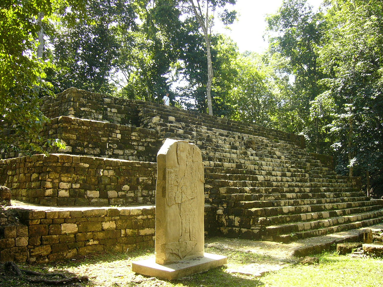
Photo Simon Burchell · CC BY-SA 3.0Source file on Wikimedia Commons
Overview
About this site
Overview
Mixco Viejo, occasionally called Jilotepeque Viejo, is an archaeological site in the north east of the Chimaltenango department of Guatemala, some 50 kilometres (31 mi) north of Guatemala City and 4 kilometres (2.5 mi) from the junction of the rivers Pixcaya and Motagua. It is a moderate-sized ruined city of the Postclassic Maya civilization.
The site is now identified as Jilotepeque Viejo, the capital of the Chajoma kingdom, and not the Poqomam capital of the same name known from colonial records.
Read on Wikipedia5 min readCC BY-SA 4.0
Where it sits in time
The site's dated range, placed against world reference points.
The scale is logarithmic: each step to the left is about ten times older than the last.
Article
Mixco Viejo
It consists of 15 groups, labelled A to L by archaeologists, containing the remains of over 120 major structures, including temples, palaces and courts for the Mesoamerican ballgame.
DescriptionSources for this section
- Wikipedia (English): Mixco ViejoCC BY-SA 4.0
Sources for this section
- Wikipedia (English): Mixco ViejoCC BY-SA 4.0
The ruins are strung out over 1 kilometre (0.62 mi) along a 880-metre (2,890 ft) high ridge in the municipality of San Martín Jilotepeque, surrounded by deep ravines that drop sharply into a tributary of the Pixcaya River. The site is 53.3 kilometres (33.1 mi) from Guatemala City by road. It consists of 15 groups, labelled A to L by archaeologists, containing the remains of over 120 major structures, including temples, palaces and courts for the Mesoamerican ballgame. The city originally had its main entrance on the western side.
The architecture was built with mica and pumice slabs, in some cases coated with stucco. Stone sculpture is almost totally absent; the only example is a ballcourt marker in the form of a serpent's head with jaws agape and a human head emerging from its mouth. Some buildings were decorated with painted stucco, but only a few fragments remain. The relatively short period of occupation led to an unusual unity of architectural styles for a Mesoamerican city.
Group A lies at the northern end of the ridge. Pyramid A1, one of its principal structures, is 6.9 metres (23 ft) high and measures 15.4 by 7.25 metres (50.5 by 23.8 ft) at the base. It was built of cut stone, has four stepped levels each ending in a cornice, and faces west onto the plaza with two stairways of 27 steps each, flanked by smooth balustrades. Its summit supports a 60-centimetre (24 in) high platform that once formed the base of a summit temple. The pyramid was built over an earlier two-level stucco platform. Platforms A2 and A3 were each built in successive versions, the final ones after a new retaining wall some 12 metres (39 ft) further out had been built and the area behind it filled in to create an expanded terrace.
HistorySources for this section
- Wikipedia (English): Mixco ViejoCC BY-SA 4.0
Sources for this section
- Wikipedia (English): Mixco ViejoCC BY-SA 4.0
Around 1450 the Chajoma, led by their king Lajuj No'j, moved to the site from Ochal to make their capital more inaccessible to hostile neighbours. In spite of this, the Kaqchikel kingdom of Iximche defeated the Chajoma and the city became subject to it. Groups C and E show Kaqchikel influence in their architecture, while groups A and B have a purer Chajoma style, and both ballcourts appear to have been remodelled in the Kaqchikel fashion with thick coatings of stucco. Shortly before the Spanish conquest the Chajoma under their lord Achi Q'alel rebelled against the Kaqchikels of Iximche.
The Chajoma may initially have allied themselves with the Spanish together with Iximche, and may have joined the general Kaqchikel uprising in 1524. When the lords of Iximche broke their alliance with the conquistadors, they took refuge in Jilotepeque. The site was abandoned after the Spanish conquest, its inhabitants were moved to San Martín Jilotepeque, and the area was never reoccupied. Almost all archaeological finds, including earlier versions of later structures, date to the last few hundred years before the conquest. A population estimate based on residential remains gives approximately 1450 to 1600 inhabitants.
Traces of charcoal at the base of the old retaining wall of Group A have been radiocarbon dated to the 13th century, indicating that the expansion of Group A took place no earlier than that. Because the group has two ballcourts, it is possible that the city served as a regional centre for the ballgame during the Postclassic.
NameSources for this section
- Wikipedia (English): Mixco ViejoCC BY-SA 4.0
Sources for this section
- Wikipedia (English): Mixco ViejoCC BY-SA 4.0
The site was named Mixco Viejo ('Old Mixco') after being erroneously associated with the Postclassic Poqomam capital of that name in colonial records. The historical Mixco Viejo has been identified as Chinautla Viejo, near the modern town of Mixco, a defensive mountain-top city founded in the 12th century AD that was attacked by the Spanish in 1525 and burned on the orders of Pedro de Alvarado. Doubts about the identification of the archaeological site were first raised by Robert M. Carmack, who realised that it lay within the linguistic area of the Kaqchikels and not that of the Poqomam. No evidence of the fine polychrome ceramic production for which the Poqomam were known had been recovered, and the ruins were considered too distant from colonial Mixco. The Chajoma apparently knew the site by several names, including Chuapec Kekacajol Nima Abaj ('Great stone in front of the Cave of the Children of Night'), Zakicajol and Nimcakajpec.
Research historySources for this section
- Wikipedia (English): Mixco ViejoCC BY-SA 4.0
Sources for this section
- Wikipedia (English): Mixco ViejoCC BY-SA 4.0
The German geographer Karl Sapper visited the ruins in 1896 and published a brief description and site map two years later, and he labelled the archaeological groups and their structures. The American archaeologist A. Ledyard Smith visited in 1949. Excavations were carried out from 1954 through 1967 by the Musée de l'Homme of Paris under Henri Lehmann, who believed he was excavating the Poqomam capital described in colonial records. The Chajoma ruins have therefore been investigated archaeologically under the assumption that they were the Poqomam capital, and this confusion has hindered study. When excavated, the surface was found to be littered with abundant obsidian blades and arrowheads; the San Martín Jilotepeque obsidian source lies close by.
ConservationSources for this section
- Wikipedia (English): Mixco ViejoCC BY-SA 4.0
Sources for this section
- Wikipedia (English): Mixco ViejoCC BY-SA 4.0
The site was restored during the archaeological investigations but suffered considerable damage in the 1976 Guatemala earthquake, which destroyed some of the restoration work; some of the damage has since been repaired. It was declared a protected archaeological zone by Ministerial Accord 1210 of the Guatemalan Ministry of Education on 12 June 1970. It is open to the public and has a small museum.
Tradition and region
About this kind of monument
Mesoamerican stelae and carved stone
Mesoamerica's civilisations raised carved stone monuments. Maya stelae are tall sculpted stone shafts, often paired with low circular stones called altars, though their actual function is uncertain. Many stelae are carved in low relief, though plain ones are found throughout the Maya region. The sculpting of these monuments spread across the Maya area in the Classic Period (about 250 to 900 CE), and the pairing of sculpted stela and altar is a hallmark of Classic Maya civilisation. The earliest dated stela found in place in the Maya lowlands comes from Tikal in Guatemala, and during the Classic Period almost every Maya kingdom in the southern lowlands raised stelae in its ceremonial centre.
The Olmec colossal heads, much older, are stone representations of heads carved from large basalt boulders, from 1.17 to 3.4 metres high. They date from at least 900 BCE and are a distinctive feature of Olmec civilisation. All portray individuals with distinctive features of the people who still live in Tabasco and Veracruz, and the backs are often flat. The boulders came from the Sierra de los Tuxtlas mountains in Veracruz, and given the weight of the stone, which was moved over 150 kilometres, much labour was needed.
Many Maya stelae carry inscriptions in hieroglyphs with dates in the Long Count calendar, and so can be dated to the day. This makes them among the most precisely dated monuments in the Atlas. They commemorate rulers and events, not the dead in general.
The Atlas's records in Mexico, Guatemala and Belize are mostly Maya sites with stelae, altars and carved monuments.
When visiting, look at the carved figure on the front, which is usually a ruler, and at the glyphs on the sides and back. Many stelae are now protected by roofs.
Paraphrased from Wikipedia: Maya stelae, Wikipedia: Olmec colossal heads, Wikipedia: Stele · CC BY-SA 4.0
From the article
Dated moments in the story
- 900 CE
It is one of very few such monuments raised in the Maya highlands and such stelae are characteristic of the Classic Period (c. 250–900).
Source - 1450
The site is 53.3 kilometres (33.1 mi) from Guatemala City by road. All dates are approximate. Around 1450 the Chajoma, led by their king Lajuj No'j, moved to Mixco Viejo (Jilotepeque Viejo) from Ochal to make their capital more inaccessible to their hostile neighbours.
Source - 1524
At the time of the Spanish conquest, the Chajoma of Jilotepeque Viejo may have initially allied themselves with the Spanish together with Iximche and have joined in the general Kaqchikel uprising against the Spanish in 1524. The site was abandoned after the conquest and never reoccupied.
Source - 1524
It is possible that the Chajoma of Mixco Viejo (Jilotepeque Viejo) initially allied themselves with the Spanish together with the Kaqchikel kingdom of Iximche, and that they also rebelled against the Spanish in 1524. It is known that when the lords of Iximche broke their alliance with the conquistadors, they took...
Source - 1525
Chinautla Viejo was attacked by the invading Spanish in 1525; the first two attacks against the heavily fortified city were unsuccessful.
Source - 1525
In 1525 Pedro de Alvarado sent a small company to conquer Mixco Viejo (Chinautla Viejo), the capital of the Poqomam.
Source - 1976
Although the site was restored during the archaeological investigations, it suffered considerable damage in the 1976 Guatemala earthquake.
Source - 1976
Although the pyramid was restored after it was excavated, the 1976 Guatemala earthquake caused considerable damage and the upper portion of the pyramid was reduced to rubble.
Source - 1976
A total of 52 urns were excavated from the ruins of Jilotepeque Viejo; 8 of these were destroyed by the 1976 earthquake leaving 44 available for study.
Source - 1998
Twelve of these were in the collection of the Musée de l'Homme in Paris for approximately thirty years; These urns, together with all other artefacts from Mixco Viejo (Jilotepeque Viejo), were repatriated to Guatemala in 1998. Each urn contained the cremated remains of a single adult.
Source
Photographs
5 photographs, each with its author and licence
More photographs
Lore
Evidence & Lore
What the sources actually support — and, kept apart, what has been claimed.
What the evidence supports
Dates
Est. 1200 BCE–900 CEHow this date was established: Type comparisonTypological estimate, not a date for this site: a other in Mesoamerica is normally dated between 1200 BCE and 900 CE (Atlas typological table).Source for this date
Measured facts
- Mainstream position
- Recent investigations identify the ruins as the capital of the Kaqchikel-speaking Chajoma Maya, with the older identification arising from confusion over colonial records.Source: Mainstream position
- Location
- Chimaltenango department, GuatemalaSource: Location
- Culture
- Postclassic MayaSource: Culture
- Correct identification
- Jilotepeque Viejo, capital of the Chajoma kingdomSource: Correct identification
- Former identification
- Poqomam capital called Mixco ViejoSource: Former identification
- Estimated population
- Approximately 1,500 inhabitantsSource: Estimated population
- Protection
- Protected archaeological zone since 12 June 1970Source: Protection
Alternative claims
Alternative claims about this site, kept in their own block and labelled with where they stand.
The ruins at Mixco Viejo are the historical Poqomam capital described in colonial records.
Tested: not supportedSource for this claim: The ruins at Mixco Viejo are the historical Poqomam capital described in colonial records.
Where it stands
Guatemala
The pin marks the monument itself — its exact point.
- Coordinates
- 14°52′18″ N, 90°39′51″ WFor a GPS or map app: 14.87167, -90.66417
Access is as our sources describe it; we have not visited the site to check.
Nearby
The closest sites in the Atlas, by straight line.




Sources
Every record behind this page, with the link it came from.
2 sources behind this page
- 01Wikidata Q652792wikidata.org
- 02Fringe claim sourceen.wikipedia.org
Image files
- Mixco Viejo 1.JPGSimon BurchellCC BY-SA 3.0
- Mixco Viejo 10.JPGSimon BurchellCC BY-SA 3.0
- Mixco Viejo.jpgFernando ReyesCC BY 2.0
- Mauricio Osorio Lajuj.jpgMauricio Osorio LajujCC BY-SA 4.0
- Mixco Viejo structure B-X 3.jpgFernando Reyes Palencia from Guatemala, GuatemalaCC BY-SA 2.0
Report a correctionWrong date, name, photograph or source? Tell us and it will be put right.
Lore, kept apart
Legends and claims
These are stories and claims reported by the sources. They are not evidence, and they never stand in for the dating above.
- Tested: not supported
The ruins at Mixco Viejo are the historical Poqomam capital described in colonial records.
Source
Around this place
The ten nearest sites, by compass
Credit
Text, licence and sources
Adapted from the Wikipedia article "Mixco Viejo" (English), licensed CC BY-SA 4.0; authors are listed in the page history. Reused under CC BY-SA 4.0. Read on Wikipedia · Edit history and authors
- Wikipedia (English): Mixco ViejoCC BY-SA 4.0
- Wikidata Q652792CC0