
Henge with stone settingsFringe site
Stones of Stenness
Also known asStanding Stones of Stenness
Datedc. 3100–2170 BCE
Photo Max Reeves · CC BY-SA 4.0Source file on Wikimedia Commons
Overview
About this site
Overview
The Standing Stones of Stenness are a Neolithic henge monument with stone settings, five miles northeast of Stromness on the mainland of Orkney, Scotland. They may be the oldest henge site in the British Isles.
The monument forms part of the Heart of Neolithic Orkney World Heritage Site and is cared for by Historic Environment Scotland as a scheduled monument.
Read on Wikipedia3 min readCC BY-SA 4.0
Age sources
How old this site is, and who says so.
Range across all claimsc. 3100–2170 BCE
MeasuredWhat this badge means
A physical measurement of this site: a radiocarbon date, a tree-ring count, a luminescence date, or a record that can itself be dated.
- 2390–2170 BCERadiocarbon dating10 radiocarbon dates in the p3k14c database (Bird et al. 2022, Scientific Data 9:27 (p3k14c radiocarbon database)) between 1431 and 4360 BP; the range shown isSource: p3k14c.org
- 3100 BCEAtlas research notesNeolithic (c. 3100 BCE commonly cited; possibly oldest henge in the British Isles)Source: en.wikipedia.org
Where it sits in time
The site's dated range, placed against world reference points.
The scale is logarithmic: each step to the left is about ten times older than the last.
Article
Stones of Stenness
The surviving stones stand on a promontory on the south bank of the stream that joins the Loch of Stenness and the Loch of Harray.
SettingSources for this section
- Wikipedia (English): Standing Stones of StennessCC BY-SA 4.0
Sources for this section
- Wikipedia (English): Standing Stones of StennessCC BY-SA 4.0
The surviving stones stand on a promontory on the south bank of the stream that joins the Loch of Stenness and the Loch of Harray. The stream was once crossed by a stepping stone causeway. The Ring of Brodgar lies about 1.2 km (0.75 mi) to the north-west, and Maeshowe chambered cairn about 1.2 km (0.75 mi) to the east; several other Neolithic monuments lie nearby, suggesting that the area had particular importance.
DescriptionSources for this section
- Wikipedia (English): Standing Stones of StennessCC BY-SA 4.0
Sources for this section
- Wikipedia (English): Standing Stones of StennessCC BY-SA 4.0
Today the site lacks its encircling ditch and bank, but excavation has shown it was a henge. The stones are thin slabs, approximately 30 cm (12 in) thick, with sharply angled tops. Four, up to about 5 m (16 ft) high, are the survivors of a stone circle of up to 12 stones, laid out in an ellipse about 32 m (105 ft) in diameter on a levelled platform of 44 m (144 ft) in diameter surrounded by a ditch. The ditch is cut into rock by as much as 2 m (6.6 ft), is 7 m (23 ft) wide, and is surrounded by an earth bank with a single entrance causeway on the north side, facing towards the Neolithic Barnhouse Settlement.
The Watch Stone stands outside the circle to the north-west and is 5.6 m (18 ft) high; the stump of a second stone was found there in the 1930s. At the centre of the platform is a square stone setting, referred to as a 'hearth', where cremated bone, charcoal and pottery were found. Animal bones were found in the ditch, and the pottery links the monument to Skara Brae and Maeshowe.
DatingSources for this section
- Wikipedia (English): Standing Stones of StennessCC BY-SA 4.0
Sources for this section
- Wikipedia (English): Standing Stones of StennessCC BY-SA 4.0
Based on radiocarbon dating, it is thought that work on the site had begun by 3100 BCE. The catalogue also records a radiocarbon range of 2390 to 2170 BCE.
NameSources for this section
- Wikipedia (English): Standing Stones of StennessCC BY-SA 4.0
Sources for this section
- Wikipedia (English): Standing Stones of StennessCC BY-SA 4.0
The name, pronounced stane-is in Orcadian dialect, comes from Old Norse and means stone headland.
FolkloreSources for this section
- Wikipedia (English): Standing Stones of StennessCC BY-SA 4.0
Sources for this section
- Wikipedia (English): Standing Stones of StennessCC BY-SA 4.0
Even in the 18th century the site was associated with traditions and rituals relating to Norse gods, and Walter Scott visited it in 1814. A stone known as the Odin Stone, which stood in the field north of the henge, was pierced with a circular hole and was used by local couples for plighting engagements by holding hands through the gap. It was believed to have magical power, and there was a reported tradition of making oaths with one's hand in the stone, known as taking the 'Vow of Odin'.
Later historySources for this section
- Wikipedia (English): Standing Stones of StennessCC BY-SA 4.0
Sources for this section
- Wikipedia (English): Standing Stones of StennessCC BY-SA 4.0
In December 1814 Captain W. Mackay, who owned farmland near the stones, decided to remove them because local people were trespassing on his land to use them in rituals. He smashed the Odin Stone, destroyed another stone and toppled a third before he was stopped. The toppled stone was re-erected in 1906 along with some inaccurate reconstruction inside the circle. In the 1970s a dolmen structure was toppled because of doubts about its authenticity; the two upright stones remain. The Heart of Neolithic Orkney was inscribed as a World Heritage site in December 1999.
ContextSources for this section
- Wikipedia (English): Standing Stones of StennessCC BY-SA 4.0
Sources for this section
- Wikipedia (English): Standing Stones of StennessCC BY-SA 4.0
A henge is a Neolithic earthwork, typically a roughly circular or oval bank with an internal ditch around a central flat area more than 20 metres across. Because the ditch lies inside the bank, henges cannot have been built for defence, and there is typically little evidence of occupation inside them. Many British henges contain stone settings.
Tradition and region
About this kind of monument
Henges with stone settings
A henge is a Neolithic earthwork, typically a roughly circular or oval bank with an internal ditch around a central flat area more than 20 metres across. The ditch lies inside the bank, so henges cannot have been built for defence. There is typically little evidence of occupation inside a henge, though they may contain ritual structures such as stone circles or timber settings. The word is taken from Stonehenge, which is not a true henge, because its ditch lies outside its bank.
Many British henges have stone settings. Avebury in Wiltshire is a henge containing three stone circles, built over several hundred years in the third millennium BCE. In Orkney the Standing Stones of Stenness, sited on a promontory between two lochs, may be the oldest henge site in the British Isles, and the Ring of Brodgar, a henge and stone circle, stands on a narrow isthmus between the same lochs; both are part of the Heart of Neolithic Orkney World Heritage Site. In Derbyshire, Arbor Low is a henge with an egg-shaped circle of about 50 limestone blocks, one partly upright and the rest lying flat. In Cumbria, Mayburgh Henge is a large bank on a knoll close to a second henge, King Arthur's Round Table. In Yorkshire the Thornborough Henges are three aligned henges on a plateau above the River Ure, dated between 3500 and 2500 BCE and called the Stonehenge of the North. At Durrington Walls, 3.2 kilometres north-east of Stonehenge, a large Neolithic settlement preceded the henge.
Stone settings inside a henge can be earlier or later than the bank, so a henge and its stones are dated separately.
When visiting, walk the bank to get the sense of the circle, and see how the entrance gaps line up with the landscape.
Paraphrased from Wikipedia: Henge, Wikipedia: Stonehenge, Wikipedia: Avebury, Wikipedia: Thornborough Henges, Wikipedia: Standing Stones of Stenness, Wikipedia: Ring of Brodgar · CC BY-SA 4.0
From the article
Dated moments in the story
- 3100 BCE
Based on radiocarbon dating, it is thought that work on the site had begun by 3100 BCE.
Source - 1814
It was visited by Walter Scott in 1814. Other antiquarians documented the stones and recorded local traditions and beliefs about them.
Source - 1814
He started in December 1814 by smashing the Odin Stone.
Source - 1906
The toppled stone was re-erected in 1906 along with some inaccurate reconstruction inside the circle.
Source - 1999
The Heart of Neolithic Orkney was inscribed as a World Heritage site in December 1999. In addition to the Standing Stones of Stenness, the site includes Maeshowe, Skara Brae, the Ring of Brodgar and other nearby sites.
Source - 2021
Odin Stone is the name of a darkwave band formed in 2021, with members in USA and Portugal
Source
See it in 3D
An interpretive reconstruction of the monument, standing on the real ground at its exact point, under the sun for that place and season. Drag to look around it.
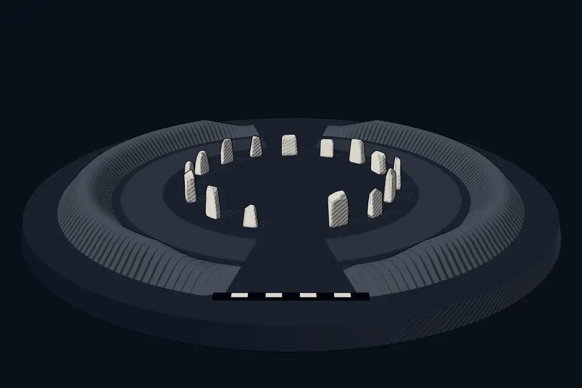
The reconstruction is ours, not a survey: it shows what a monument of this type looks like, at the size the record gives for this one.
Photographs
8 photographs, each with its author and licence
More photographs
Lore
Evidence & Lore
What the sources actually support — and, kept apart, what has been claimed.
What the evidence supports
Dates
2390–2170 BCEHow this date was established: Radiocarbon dating10 radiocarbon dates in the p3k14c database (Bird et al. 2022, Scientific Data 9:27 (p3k14c radiocarbon database)) between 1431 and 4360 BP; the range shown is the middle half of the measurements; uncalibrated ages, shown as calendar years with the conventional BP + 1950 conversion.Source for this date
Measured facts
- Mainstream position
- The source identifies the Stones of Stenness as a Neolithic monument within the Heart of Neolithic Orkney World Heritage Site.Source: Mainstream position
- Location
- five miles northeast of Stromness, mainland Orkney, ScotlandSource: Location
- Period
- NeolithicSource: Period
- Heritage status
- scheduled monument and part of the Heart of Neolithic Orkney World Heritage SiteSource: Heritage status
- Odin Stone
- pierced stone associated with handfasting, ceremonies, oaths and magical powerSource: Odin Stone
- Care
- Historic Environment ScotlandSource: Care
- Heritage designation
- scheduled monument, part of UNESCO World Heritage SiteSource: Heritage designation
Alternative claims
Alternative claims about this site, kept in their own block and labelled with where they stand.
This may be the oldest henge site in the British Isles.
UntestedSource for this claim: This may be the oldest henge site in the British Isles.
Where it stands
United Kingdom
The pin marks the monument itself — its exact point.
- Coordinates
- 58°59′38″ N, 3°12′29″ WFor a GPS or map app: 58.99389, -3.20806
Access is as our sources describe it; we have not visited the site to check.
Nearby
The closest sites in the Atlas, by straight line.


Sources
Every record behind this page, with the link it came from.
4 sources behind this page
- 01Wikidata Q1478558wikidata.org
- 02Fringe claim sourceen.wikipedia.org
- 03Wikipedia (en)en.wikipedia.org
- 04Source for this datep3k14c.org
Image files
- Orkney 2018 2.jpgMax ReevesCC BY-SA 4.0
- Orkney Stones of Stennes 01.jpgPaulT (Gunther Tschuch)CC BY-SA 4.0
- Orkney Stones of Stennes 03.jpgPaulT (Gunther Tschuch)CC BY-SA 4.0
- Orkney 2013 069.jpgArchaeology ScotlandCC BY-SA 4.0
- Orkney 2013 073.jpgArchaeology ScotlandCC BY-SA 4.0
- 2018 06 04 o ORK (89) filtered-Edit.jpgjoiseyshowaaCC BY-SA 2.0
- 2018 07 12 Schottland (113).jpgBewahrerderwerteCC BY-SA 4.0
- 2018 07 12 Schottland (114).jpgBewahrerderwerteCC BY-SA 4.0
Report a correctionWrong date, name, photograph or source? Tell us and it will be put right.
Lore, kept apart
Legends and claims
These are stories and claims reported by the sources. They are not evidence, and they never stand in for the dating above.
- Tested: not supported
This may be the oldest henge site in the British Isles.
Source
Around this place
The ten nearest sites, by compass
Credit
Text, licence and sources
Adapted from the Wikipedia article "Standing Stones of Stenness" (English), licensed CC BY-SA 4.0; authors are listed in the page history. Reused under CC BY-SA 4.0. Read on Wikipedia · Edit history and authors
- Wikipedia (English): Standing Stones of StennessCC BY-SA 4.0
- Wikidata Q1478558CC0
- Fringe claim sourceCC BY-SA 4.0