
dolmens of Cazarils
Also known asTombes de Cazarils
DatedEst. 4500–3300 BCE
Photo JYB Devot · CC BY-SA 4.0Source file on Wikimedia Commons
Overview
About this site
Overview
The Tombes de Cazarils (dolmens of Cazarils) are a group of three Neolithic tombs at Viols-le-Fort, in the department of Hérault, France. They have been linked to the Fontbouisse culture. The catalogue gives a typological estimate of 4500 to 3300 BCE.
Tombs no 1 and no 2 are about 70 m apart, and tomb no 3 lies further east, less than 200 m away. All are oval in shape, and they are situated about 2 km west of the prehistoric village of Cambous.
Read on Wikipedia2 min readCC BY-SA 4.0
Where it sits in time
The site's dated range, placed against world reference points.
The scale is logarithmic: each step to the left is about ten times older than the last.
Article
dolmens of Cazarils
Tomb no 1 was discovered in 1952 and excavated by the Centre Archéologique des Chênes Verts.
DescriptionSources for this section
- Wikipedia (French): Tombes de CazarilsCC BY-SA 4.0
Sources for this section
- Wikipedia (French): Tombes de CazarilsCC BY-SA 4.0
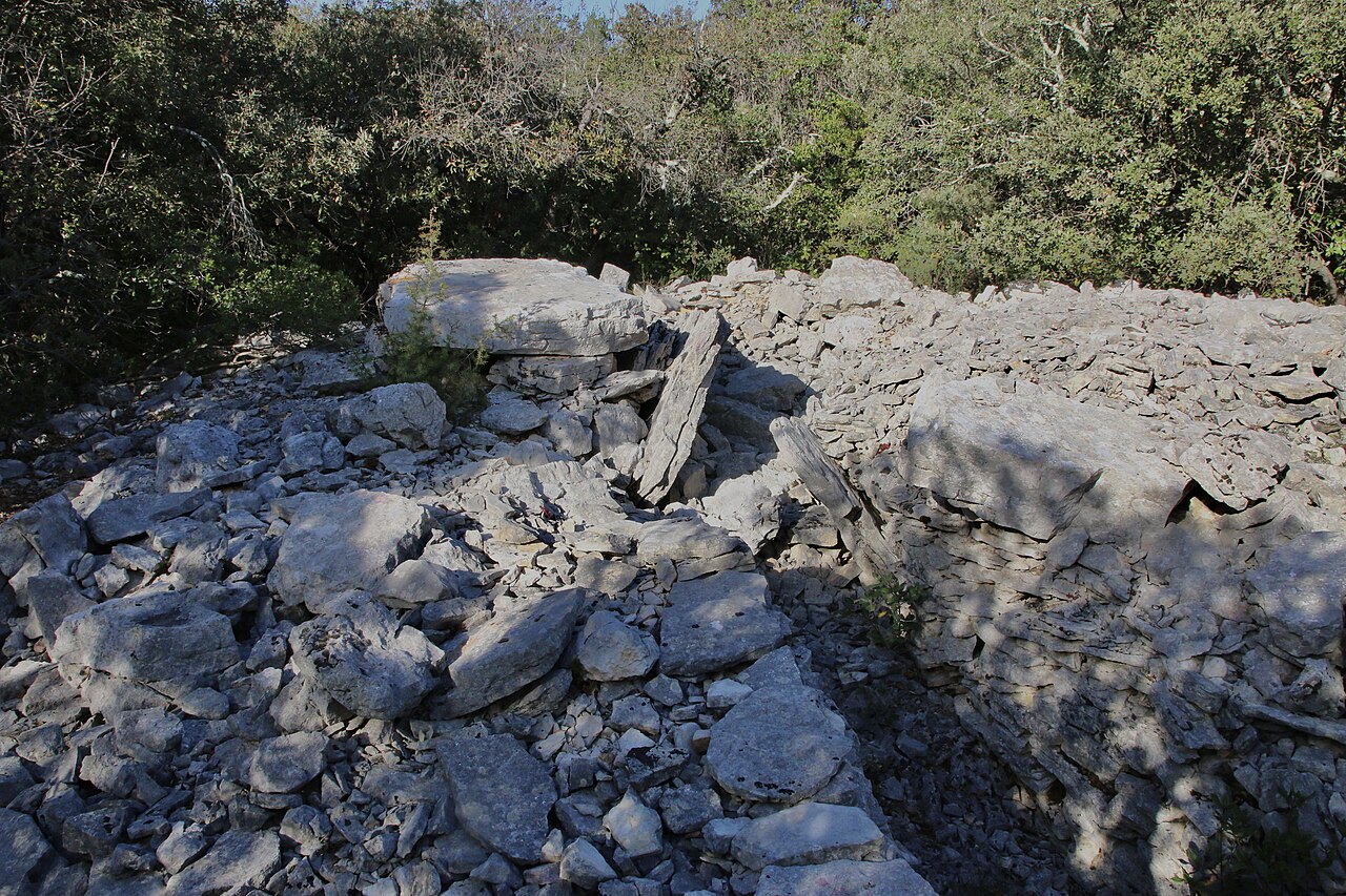
Tomb no 1 was discovered in 1952 and excavated by the Centre Archéologique des Chênes Verts. Its interior space is bounded by orthostats and its outer contour by a drystone wall, the space between being filled with rock blocks in no order. One of the orthostats is a small rectangular statue-menhir (0,71 m high, 0,33 m wide and 0,15 m thick), placed at the back of the chamber, facing the entrance, probably, according to Jean Arnal, to frighten off possible desecrators. The original is kept by the Société Archéologique de Montpellier, and a cement copy is visible on the site. The face, described as an "owl head", is formed of parallel engraved lines, with the eyes underlined by marks like tattoos. The statue is decorated with a necklace bearing a motif that could be a bead.
Tomb no 2 was discovered in the 1950s. It is larger than tomb no 1 and slightly different in construction: small drystone walls are set between the orthostats of the inner circuit, and the outer circuit is again a drystone wall enclosing internal rubble.
FindsSources for this section
- Wikipedia (French): Tombes de CazarilsCC BY-SA 4.0
Sources for this section
- Wikipedia (French): Tombes de CazarilsCC BY-SA 4.0
In tomb no 1 the archaeological material comprises pottery sherds, a few items of personal ornament and human bones, dated to the Copper Age, the Bronze Age and the early Iron Age. The excavation of tomb no 2 by the Centre Archéologique des Chênes Verts yielded only a few pottery sherds and fragments of human bone.
ContextSources for this section
- Wikipedia (French): Tombes de CazarilsCC BY-SA 4.0
Sources for this section
- Wikipedia (French): Tombes de CazarilsCC BY-SA 4.0
The Atlas's general "megalith" records for France cover a range of monuments: dolmens and covered alleys (allées couvertes), menhirs, cromlechs, tumuli, groups of stones, and polissoirs. Some of the oldest monuments in Europe are in western France.
Tradition and region
About this kind of monument
French megaliths
The Atlas's general "megalith" records for France cover a range of monuments: dolmens and covered alleys (allées couvertes), menhirs, cromlechs, tumuli, groups of stones, and polissoirs. Some of the oldest monuments in Europe are in western France, and the Carnac stones in Brittany, with more than 3,000 prehistoric standing stones, are the largest collection in the world.
A polissoir, "polisher", is a Neolithic stone tool used for polishing and sharpening stone objects, especially axes, adzes and chisels. They date to about 5,000 years ago. Polissoirs are typically large stones with smooth, concave surfaces or grooves, made of hard and abrasive rocks such as sandstone, granite or quartzite, and the surface often shows distinctive wear patterns from the back-and-forth motion used to refine the edges of tools. They come in two types: earthfast, large and immovable and found in their original position, and portable. A polissoir is not strictly a megalith, but it is recorded with them because it is a large stone of the same period.
In the Atlas a record with an unspecified type receives a broad Neolithic range, since it cannot be tied to a particular phase. Many small dolmens survive only as a few stones in a field and cannot be dated closely.
Folklore: La Roche-aux-Fées near Essé takes its name, "the fairies' rock", from a legend that fairies placed the stones.
When visiting, look for the polished grooves on boulders near dolmens, and for the way a capstone is propped.
Paraphrased from Wikipedia: Dolmen, Wikipedia: Menhir, Wikipedia: Carnac stones, Wikipedia: Polissoir, Wikipedia: La Roche-aux-Fées · CC BY-SA 4.0
From the article
Dated moments in the story
- 1950
Ces artefacts ont été datés de l'Âge du cuivre, de l'Âge du Bronze et du premier Âge du fer. Elle a été découverte dans les années 1950. De plus grande taille de la tombe n°1, sa construction est aussi légèrement différente : ici, de petits murs en pierres sèches s'intercalent entre les orthostates du pourtour...
Source - 1952
Elles sont situées à environ 2 km à l'ouest du village préhistorique de Cambous et ont été rattachées à la Culture de Fontbouisse. La tombe n°1 a été découverte en 1952 et fouillée par le Centre Archéologique des Chênes Verts.
Source
Photographs
8 photographs, each with its author and licence
More photographs
Lore
Evidence & Lore
What the sources actually support — and, kept apart, what has been claimed.
What the evidence supports
Dates
Est. 4500–3300 BCEHow this date was established: Type comparisonTypical range for megaliths in France; this site has not been dated itself. The megaliths of north-west France are among the oldest in Europe; the Carnac stones date from 4500-3300 BC.Source for this date
Where it stands
France
The pin marks the monument itself — its exact point.
- Coordinates
- 43°45′23″ N, 3°42′30″ EFor a GPS or map app: 43.75640, 3.70830
Access is as our sources describe it; we have not visited the site to check.
Nearby
The closest sites in the Atlas, by straight line.




Sources
Every record behind this page, with the link it came from.
2 sources behind this page
- 01Wikidata Q27902840wikidata.org
- 02Source for this dateen.wikipedia.org
Image files
- Tombes de Cazarils P1010004mod.jpgJYB DevotCC BY-SA 4.0
- Viols-en-laval cazarils1 02.jpgLiberligerCC BY-SA 4.0
- Viols-en-laval cazarils1 04.jpgLiberligerCC BY-SA 4.0
- Tombes de Cazarils P1010005mod.jpgJYB DevotCC BY-SA 4.0
- Viols-en-laval cazarils8.jpgFsouCC BY-SA 4.0
- Viols-en-laval cazarilsC.jpgFsouCC BY-SA 4.0
- Tombe Cazarils - SLH.jpgPicPatrimoineSLHCC BY 4.0
- Stèle de Cazarils - SLH.jpgPicPatrimoineSLHCC BY 4.0
Report a correctionWrong date, name, photograph or source? Tell us and it will be put right.
Around this place
The ten nearest sites, by compass
- Dolmen de la Draille0.2 km SW
- Dolmen de Cambous1.7 km E
- dolmens de la Limite4.0 km E
- Grand Juyan de Roubiac6.4 km E
- Boscorre Dolmen7.4 km SW
- dolmen de la Carrière de l'Espinasse7.9 km SW
- Lamalou dolmen11 km NE
- dolmen des Feuilles I12 km NE
- menhir du Lacam des Lavagnes14 km W
- menhir de la Mare des Lavagnes14 km W
Credit
Text, licence and sources
Adapted from the Wikipedia article "Tombes de Cazarils" (French), licensed CC BY-SA 4.0; authors are listed in the page history. Reused under CC BY-SA 4.0. Read on Wikipedia · Edit history and authors
- Wikipedia (French): Tombes de CazarilsCC BY-SA 4.0
- Wikidata Q27902840CC0