
Орлови скали (Сърница)
Photo Иванка Вълчанова · CC BY-SA 4.0Source file on Wikimedia Commons
Overview
About this site
Overview
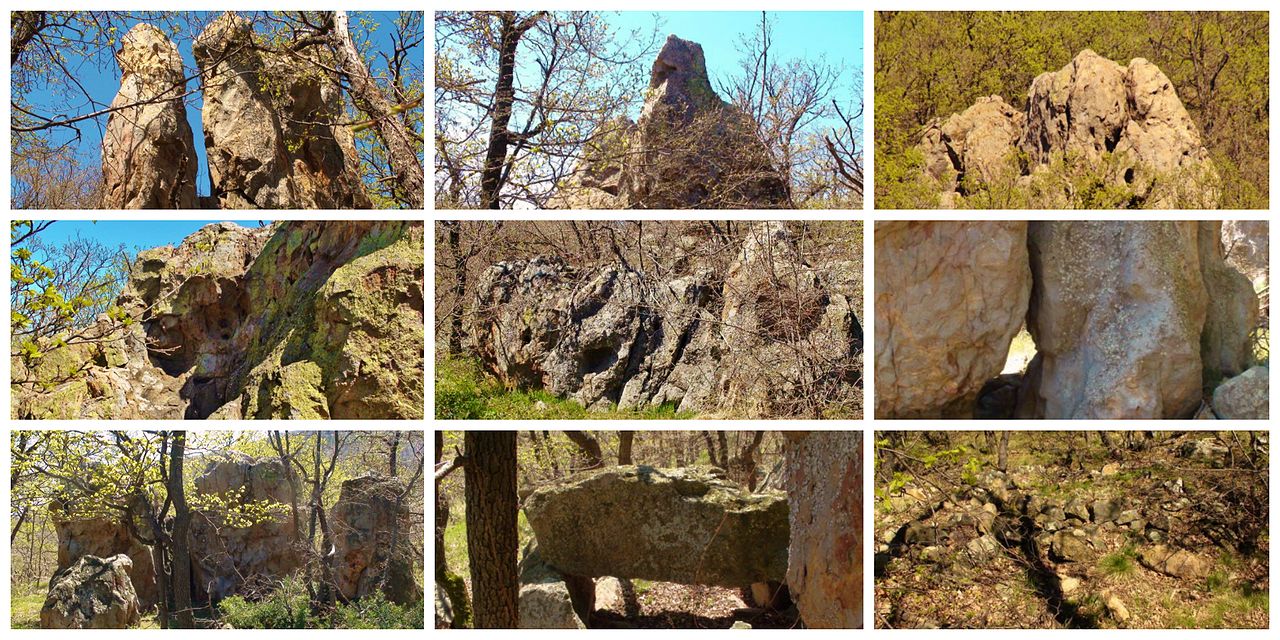
Orlovi skali (Eagle Rocks) is a rock sanctuary in the locality of the same name, 3 km west in a straight line from the centre of the village of Sărnitsa in Haskovo Province, Bulgaria. Its Turkish name is Dogan kaya, which in Bulgarian means Falcon Rocks. The complex is an ensemble of imposing rocks, some of which reach 30 – 40 m in height.
The site was declared a natural landmark in 1974. Its dating and interpretation rest largely on the field study of Professor Ana Raduncheva, who places the sanctuary in the fourth millennium BC.
Read on Wikipedia4 min readCC BY-SA 4.0
Article
Орлови скали (Сърница)
According to Raduncheva, the monumental rocks have for the most part been shaped by human hand, and monumental human profiles were formed at various places in them.
DescriptionSources for this section
- Wikipedia (Bulgarian): Орлови скали (Сърница)CC BY-SA 4.0
Sources for this section
- Wikipedia (Bulgarian): Орлови скали (Сърница)CC BY-SA 4.0
The cult niches and forms resembling human figures and animals that are typical of such sites in the Eastern Rhodope are mentioned in a number of publications from the seventies and eighties of the twentieth century, among them a work by Ivan Topalov of 1980 on the countryside around Sărnitsa. A spring, caves and trapezoid niches have been recorded here.
According to Raduncheva, the monumental rocks have for the most part been shaped by human hand, and monumental human profiles were formed at various places in them. She notes that no trace of work with metal tools is visible, which in her view means that the rocks were worked with stone.
Research historySources for this section
- Wikipedia (Bulgarian): Орлови скали (Сърница)CC BY-SA 4.0
Sources for this section
- Wikipedia (Bulgarian): Орлови скали (Сърница)CC BY-SA 4.0
In February 2016 the professional photographer Miroslav Chobanov drew attention to the site again by circulating photographs of a clearly outlined human profile in the rock masses, about 30 – 40 m high. At the beginning of March 2016 Professor Raduncheva and Associate Professor Dr Stefanka Ivanova made a field study there, during which Chobanov photographed two more profiles. Raduncheva holds that the male profile was certainly made by human hand, most probably with a stone tool.
Her hypothesis is that Orlovi skali belongs to a chain of sanctuaries in the Eastern Rhodope that includes the complexes near the villages of Tatul and Angel Voivoda, as well as Belintash, Perperek and Glukhite kamani.
DatingSources for this section
- Wikipedia (Bulgarian): Орлови скали (Сърница)CC BY-SA 4.0
Sources for this section
- Wikipedia (Bulgarian): Орлови скали (Сърница)CC BY-SA 4.0
Many pottery fragments were found during the field study. On them Raduncheva dates the sanctuary to the fourth millennium BC, with the fragments belonging to the second half of that millennium and to the Copper Age. She regards the sanctuary as part of a system of sanctuaries built in that period in the Eastern Rhodope.
An Early Iron Age fortress was built around the sanctuary. Two rock outcrops between the rocks naturally protect a space of about 1,5 decares, which is further closed by a wall of rubble stone laid without mortar. Pottery on the surface dates from the second half of the first millennium BC. The wall links the two rock masses in an arc and gives protection from the north-west. A partly preserved wall stands to a height of about 1,2 m, and about 10 m in front of the lower rock mass a bank of stones, the remains of a wall, can be seen.
InterpretationSources for this section
- Wikipedia (Bulgarian): Орлови скали (Сърница)CC BY-SA 4.0
Sources for this section
- Wikipedia (Bulgarian): Орлови скали (Сърница)CC BY-SA 4.0
In June 2016 Paulina Mihova reported a further sanctuary at Dikili tash, a few kilometres south-east of Orlovi skali. Its rocks are arranged in a semicircle for almost 1 km, and trapezoid niches are cut in places. Photographs show carved snake heads, human profiles and step-like cuttings. Raduncheva explained at a press conference that this is not a city but a series of rocks on which snake images were worked into naturally suitable forms.
Raduncheva, a long-standing researcher of the Rhodope sanctuaries, puts their number at more than 250. She dates the snake figures to around the eighth millennium BC and argues that their makers belonged to a highly developed society, led by the authority of priests, that disappeared around the fourth millennium BC. These are her views and are not established fact.
ContextSources for this section
- Wikipedia (Bulgarian): Орлови скали (Сърница)CC BY-SA 4.0
Sources for this section
- Wikipedia (Bulgarian): Орлови скали (Сърница)CC BY-SA 4.0
In the Eastern Rhodope and Strandzha mountains of Bulgaria, rocks have been cut, carved and used as sanctuaries for thousands of years. The Thracians, an Indo-European-speaking people of south-eastern Europe, reused many of these sites.
Tradition and region
About this kind of monument
Thracian rock sanctuaries of Bulgaria
In the Eastern Rhodope and Strandzha mountains of Bulgaria, rocks have been cut, carved and used as sanctuaries for thousands of years, and the Atlas lists many of them as "megaliths". The Thracians were an Indo-European-speaking people who inhabited large parts of south-eastern Europe in ancient times, including modern Bulgaria, Romania, North Macedonia, northern Greece and European Turkey, and they reused many of the sites. Strandzha has a large concentration of ruins of Thracian sanctuaries, sacrificial altars and dolmens.
Perperikon, in the Eastern Rhodope Mountains 15 kilometres north-east of Kardzhali, is an ancient Thracian city on a rocky hill 470 metres high, thought to have been a sacred place; it is described as the largest megalith ensemble site in the Balkans. In the Middle Ages it served as a fortress. Beglik Tash, a prehistoric rock sanctuary on the southern Black Sea coast north of Primorsko, was reused by Thracian tribes in the Iron Age.
Many of the places listed as megaliths here are natural rock formations. Beglik Tash is a natural rock formation of megaliths of hardened magma, from a volcano of the Mesozoic era; most of the megaliths have traces of carving for Thracian rituals, and there are the remains of a labyrinth and a "Thracian sun-clock" formed of huge stones, as well as a 150-ton rock. It is often hard to tell where nature ends and human work begins.
Dating depends on the finds in the few excavated parts, and most sites are listed with a broad range.
When visiting, look for traces of carving on the rock, and for steps and niches.
Paraphrased from Wikipedia: Thracians, Wikipedia: Perperikon, Wikipedia: Beglik Tash, Wikipedia: Strandzha · CC BY-SA 4.0
Photographs
1 photograph, each with its author and licence
Where it stands
Bulgaria
The pin marks the monument itself — its exact point.
- Coordinates
- 41°52′05″ N, 25°15′08″ EFor a GPS or map app: 41.86800, 25.25220
Access is as our sources describe it; we have not visited the site to check.
Nearby
The closest sites in the Atlas, by straight line.


Sources
Every record behind this page, with the link it came from.
1 source behind this page
- 01Wikidata Q24717888wikidata.org
Image files
- Орлови скали.jpgИванка ВълчановаCC BY-SA 4.0
Report a correctionWrong date, name, photograph or source? Tell us and it will be put right.
Around this place
The ten nearest sites, by compass
Credit
Text, licence and sources
Adapted from the Wikipedia article "Орлови скали (Сърница)" (Bulgarian), licensed CC BY-SA 4.0; authors are listed in the page history. Reused under CC BY-SA 4.0. Read on Wikipedia · Edit history and authors