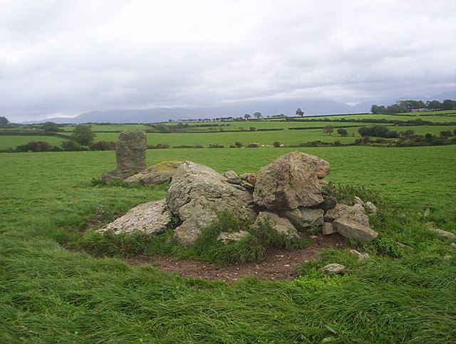
Hendrefor Burial Chambers
DatedEst. 4000–2500 BCE
Photo Michael Murray · CC BY-SA 2.0Source file on Wikimedia Commons

Overview
About this site
Overview
The Hendrefor Burial Chambers are the remains of a chambered tomb near the farm of Ucheldref in Cwm Cadnant, south-west of Llanddona on the island of Anglesey, Wales. The monument is a scheduled monument.
Today it consists of two heaps of rock with one upright stone in a pasture. The catalogue record gives a typological estimate of 4000 to 2500 BCE.
Read on Wikipedia2 min readCC BY-SA 4.0
Where it sits in time
The site's dated range, placed against world reference points.
The scale is logarithmic: each step to the left is about ten times older than the last.
Article
Hendrefor Burial Chambers
0 m apart, at the north-west and south-east of a tumulus or cairn whose material was cleared away long ago.
DescriptionSources for this section
- Wikipedia (German): HendreforCC BY-SA 4.0
Sources for this section
- Wikipedia (German): HendreforCC BY-SA 4.0
The stones originally formed two chambers, about 7.0 m apart, at the north-west and south-east of a tumulus or cairn whose material was cleared away long ago. Both chambers had been destroyed by the early nineteenth century.
Later historySources for this section
- Wikipedia (German): HendreforCC BY-SA 4.0
Sources for this section
- Wikipedia (German): HendreforCC BY-SA 4.0
The western chamber, with its supporting stones and a capstone 2.6 m long that had been rolled off, was destroyed in the late eighteenth century. At that time the eastern chamber still stood, with its capstone measuring 2.8 by 2.4 m resting on two or four supporting stones. It was destroyed before 1825, leaving only the single standing stone.
InterpretationSources for this section
- Wikipedia (German): HendreforCC BY-SA 4.0
Sources for this section
- Wikipedia (German): HendreforCC BY-SA 4.0
The surviving stone has a faintly L-shaped profile. This may result from a piece splitting off during the destruction, or it may be an original feature, similar to that found on some stones of Trethevy Quoit in Cornwall, serving as an opening for the periodic bringing in or removal of bones from the chamber.
ContextSources for this section
- Wikipedia (German): HendreforCC BY-SA 4.0
Sources for this section
- Wikipedia (German): HendreforCC BY-SA 4.0
A chambered cairn is a stone mound over one or more burial chambers, usually entered by a passage.
Tradition and region
About this kind of monument
Orkney, Caithness and Scottish chambered cairns
Scotland, and above all Orkney and Caithness, has many Neolithic tombs. A chambered cairn is a stone mound over one or more burial chambers, entered by a passage. Maeshowe on Mainland Orkney was probably built around 2800 BCE, and gives its name to the Maeshowe type of cairn, which is limited to Orkney; its entrance passage is about 11 metres long, and sunlight enters it at the winter solstice and reaches the rear wall of the chamber. It is part of the Heart of Neolithic Orkney World Heritage Site. In the twelfth century Norse visitors broke in through the roof and left runic inscriptions inside.
Orkney also has the Quoyness cairn on Sanday, built about 3000 BCE and similar in design to Maeshowe, where the remains of several people were found in 1867. Unstan, on a promontory into the Loch of Stenness, is an atypical hybrid of the two main types of Orkney cairn and gave its name to Unstan ware, a type of pottery. The Tomb of the Eagles at Isbister on South Ronaldsay stands on a cliff edge.
On the mainland, the Grey Cairns of Camster in Caithness are two large chambered cairns dating to around 3000 BCE, among the oldest structures in Scotland, with central chambers reached by narrow passages. They were excavated and restored by Historic Environment Scotland and are open to the public.
Dating rests on radiocarbon dates from bone and on pottery, but many cairns were opened by antiquarians in the nineteenth century before records were kept. The Atlas gives a typological range of the fourth to third millennium BCE for most.
When visiting, check access in advance, since some cairns have narrow passages and others are open only at set times.
Paraphrased from Wikipedia: Chambered cairn, Wikipedia: Maes Howe, Wikipedia: Quoyness chambered cairn, Wikipedia: Unstan chambered cairn, Wikipedia: Isbister Chambered Cairn, Wikipedia: Midhowe Chambered Cairn, Wikipedia: Grey Cairns of Camster · CC BY-SA 4.0
From the article
Dated moments in the story
- 1825
Sie ist dann vor 1825 bis auf den einsam stehenden Stein zerstört worden.
Source
Photographs
1 photograph, each with its author and licence
Lore
Evidence & Lore
What the sources actually support — and, kept apart, what has been claimed.
What the evidence supports
Dates
Est. 4000–2500 BCEHow this date was established: Type comparisonTypical range for chambered cairns in United Kingdom; this site has not been dated itself. Stone-chambered cairns appear in the early Neolithic (4000-3300 BC) and in the later Neolithic (3300-2500 BC) massive circular enclosures emerge.Source for this date
Where it stands
United Kingdom
The pin marks the monument itself — its exact point.
- Coordinates
- 53°16′23″ N, 4°10′31″ WFor a GPS or map app: 53.27292, -4.17514
Access is as our sources describe it; we have not visited the site to check.
Nearby
The closest sites in the Atlas, by straight line.
- Stone row (alignment)Cremlyn Stone Alignment4000–2400 BCE
- Menhir (standing stone)Cremlyn Standing Stones2800–1800 BCE
- Menhir (standing stone)Cremlyn South Standing Stone2800–1800 BCE
 Four Stones Known As The Three Leaps4000–2400 BCE
- Menhir (standing stone)Llanddona Standing Stone2800–1800 BCE
 Ty-Wyn Standing Stone2800–1800 BCE
- Menhir (standing stone)Llandegfan Maen Hir2800–1800 BCE
- Menhir (standing stone)Pen-y-Maen Standing Stone2800–1800 BCE


Sources
Every record behind this page, with the link it came from.
2 sources behind this page
- 01Wikidata Q20588962wikidata.org
- 02Source for this dateen.wikipedia.org
Image files
Report a correctionWrong date, name, photograph or source? Tell us and it will be put right.
Around this place
The ten nearest sites, by compass
- Cremlyn Stone Alignment1.6 km NE
- Cremlyn Standing Stones2.1 km E
- Cremlyn South Standing Stone2.1 km E
- Four Stones Known As The Three Leaps2.5 km NW
- Llanddona Standing Stone2.9 km NE
- Ty-Wyn Standing Stone3.4 km S
- Llandegfan Maen Hir3.4 km S
- Pen-y-Maen Standing Stone3.7 km SE
- Tumulus and site of Tumulus East of Llanddyfnan4.3 km W
- Llanddyfnan Standing Stone5.0 km W
Credit
Text, licence and sources
Adapted from the Wikipedia article "Hendrefor" (German), licensed CC BY-SA 4.0; authors are listed in the page history. Reused under CC BY-SA 4.0. Read on Wikipedia · Edit history and authors
- Wikipedia (German): HendreforCC BY-SA 4.0
- Wikidata Q20588962CC0