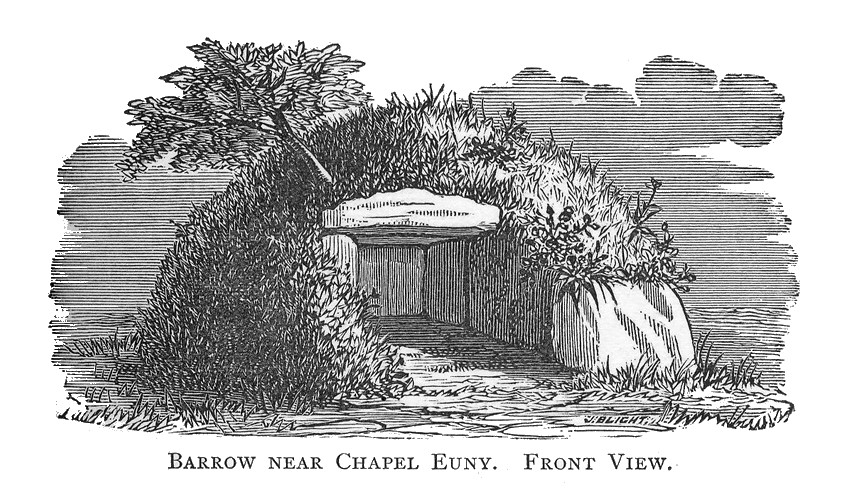
Brane Barrow
Also known asChapel Euny barrow · Entrance grave 290m south west of Brane End Farm
Datedc. 1750 BCE
Photo William Copeland Borlase · Public domainSource file on Wikimedia Commons

Overview
About this site
What the sources say
Brane Barrow, or Chapel Euny Barrow, is a Neolithic entrance grave located near the hamlet of Brane, Cornwall, England, United Kingdom. It is considered to be one of the smallest and best preserved burial monuments in Britain.
Read on Wikipedia4 min readCC BY-SA 4.0
The full article
Brane Barrow: the whole story
In briefSources for this section
- Wikipedia (English): Brane BarrowCC BY-SA 4.0
Sources for this section
- Wikipedia (English): Brane BarrowCC BY-SA 4.0
Brane Barrow, also known as Chapel Euny Barrow, is a Neolithic entrance grave near the hamlet of Brane in Cornwall, England. It lies 317 yards (290m) south west of Brane End Farm and 1.2 miles (2 km) southwest of Sancreed, in low-lying pasture close to the upper Lamorna River.
The monument is a circular mound of earth and stones measuring up to 20 feet (6.1 m) in diameter. Large granite blocks form its border and retain the mound. Inside is a rectangular stone-lined chamber measuring 7.5 ft (2.3 m) long by 4 ft (1.2 m) wide and 3 ft (90 cm) high, roofed by two capstones after a third was removed. An entrance passage on the southeast leads directly into the chamber, which the mound was built to cover only barely. Earth has been taken from the south side, exposing part of the chamber.
William Borlase discovered the barrow in 1863 while exploring an underground structure, probably Carn Euny, nearby. He called it the barrow near Chapel Euny because of its location near the village of Chapel Euny. The farmer who owned the site said he had not destroyed the barrow because it provided good shelter for sheep and pigs.
Entrance graves belong to the later Neolithic and Bronze Age (c. 2500-1000 BC) and are found in places including the Isles of Scilly, west Cornwall, south-east Ireland, south-west Scotland, Brittany and the Channel Islands. Monuments of this kind typically have a circular mound bordered by a stone kerb over a rectangular burial chamber, entered through a narrow, stone-lined passage. Brane Barrow is considered one of the smallest and best preserved burial monuments in Britain, and can be visited with permission at Brane farm.
History and datingSources for this section
- Wikipedia (English): Brane BarrowCC BY-SA 4.0
Sources for this section
- Wikipedia (English): Brane BarrowCC BY-SA 4.0
Entrance graves date to the later Neolithic era and Bronze Age (c. 2500-1000 BC). Circular in shape, most entrance graves were built with a mound of heaped rubble and soil, typically up to 82 feet (25m) in diameter. The perimeter of the mound was marked with kerbstone. It held a rectangular chamber built of stone slabs or coursed rubble stone, or a combination of the two. The chamber roof was made of stone slabs, called capstones. Access to the chamber was through an opening in the mound's kerb or outer edge.
Brane barrow was first discovered by William Borlase in 1863 while he was exploring an underground structure, probably Carn Euny, a short distance away. Borlase refers to the structure as the barrow near Chapel Euny, because of its location near the village of Chapel Euny. The farmer who owned the site told Borlase that he did not destroy the barrow because it was provided a good shelter for sheep and pigs.
DescriptionSources for this section
- Wikipedia (English): Brane BarrowCC BY-SA 4.0
Sources for this section
- Wikipedia (English): Brane BarrowCC BY-SA 4.0
Brane Barrow is a scheduled burial monument located 317 yards (290m) south west of Brane End Farm, and 1.2 miles (2 km) southwest of the village of Sancreed, in Cornwall. The monument includes an entrance grave, situated in a low-lying pasture close to the upper Lamorna River.
The barrow is a circular mound of earth and stones, measuring up to 20 feet (6.1 m) in diameter. The mound is surrounded and retained by a border of large granite blocks. It contains a rectangular stone-lined chamber measuring 7.5 ft (2.3 m) long by 4 ft (1.2 m) wide and 3 ft (90 cm) high. The chamber is roofed with two capstones: a third capstone was removed at some point. On the southeast is an entrance passage that leads directly into the chamber. It is unusual that the mound was constructed to just barely cover the chamber. The mound is damaged on the south side where the earth has been removed to expose the chamber. The burial monument can be visited with permission at Brane farm.
How this page was madeSources for this section
- Wikipedia (English): Brane BarrowCC BY-SA 4.0
Sources for this section
- Wikipedia (English): Brane BarrowCC BY-SA 4.0
The summary at the top of this page was written by MiniMax-M3 (2026-11-07) from the cited Wikipedia article “Brane Barrow”. The numbers in it were checked automatically against the source text. The rest of the page is the article itself, the structured records and computed distances.
Tradition and region
About this kind of monument
Entrance graves
An entrance grave is a type of Neolithic and early Bronze Age chamber tomb found primarily in Great Britain. The monument typically consisted of a circular mound bordered by a stone kerb, erected over a rectangular burial chamber and entered through a narrow, stone-lined passage. They have been found in the Isles of Scilly, west Cornwall, south-east Ireland, south-west Scotland, Brittany and the Channel Islands. They are often called the Scillonian group, after the Isles of Scilly, which lie 25 miles (40 km) west of Land's End and where most of them are found.
The Atlas's British records are mostly Scillonian, with sites on the Isles of Scilly such as Innisidgen and Bant's Carn. The islands were first settled in the Neolithic, around 2500 BCE, and burials on them range from the later Neolithic to the Middle Bronze Age, about 2500 to 1000 BCE. More than eighty entrance graves have been recorded on the islands. Many date to the late Neolithic and continued in use until the beginning of the eighth century BCE, and they went on being built for many years after individual burial had become the standard practice on the mainland of Britain.
An entrance grave usually consisted of a circular mound of stacked rubble and earth, generally up to 25 metres across, with its edge marked with stones. Excavated graves have held human remains, cremation urns and pottery fragments; the Knackyboy Carn grave on St Martin's uncovered sixty or more cremated individuals. Besides burials, it has been suggested that entrance graves could have served ritual and cultural purposes, or marked land boundaries between family groups.
Where graves are not excavated the Atlas gives a Neolithic to Bronze Age range.
When visiting the Isles of Scilly, look for the kerbed round mounds on the headlands.
Paraphrased from Wikipedia: Entrance grave, Wikipedia: Isles of Scilly · CC BY-SA 4.0
Photographs
1 photograph, each with its author and licence
Where it stands
United Kingdom
The pin marks the monument itself — its exact point.
- Coordinates
- 50°05′48″ N, 5°38′06″ WFor a GPS or map app: 50.09680, -5.63500
Access is as our sources describe it; we have not visited the site to check.
Nearby
The closest sites in the Atlas, by straight line.
 Boscawen-Un3200–2500 BCE
 Large regular stone circle called Boscawen-Un with two outlying standing stones west of Boscawen Noon Farm3200–2500 BCE
 Chapel Carn Brea Tomb
- Megalithic mound (tumulus with integral stones)Round barrow 550yds (500m) N of Chycarne4000–800 BCE
- Menhir (standing stone)Standing stone 200yds (180m) W of Chycarne2800–1800 BCE
 Standing stone known as the 'Blind Fiddler', 405m south east of Lesbew Farm2800–1800 BCE
- Megalithic mound (tumulus with integral stones)Round cairn 230m SSW of Higher Tregiffian4000–800 BCE
- Megalithic mound (tumulus with integral stones)Three bowl barrows 380m south east of Bryndowr4000–800 BCE


Sources
Every record behind this page, with the link it came from.
2 sources behind this page
- 01Wikidata Q898472wikidata.org
- 02Wikipedia: Brane Barrowen.wikipedia.org
Image files
- Braneborlase.jpgWilliam Copeland BorlasePublic domain
Report a correctionWrong date, name, photograph or source? Tell us and it will be put right.
Around this place
The ten nearest sites, by compass
- Boscawen-Un1.4 km SE
- Large regular stone circle called Boscawen-Un with two outlying standing stones west of Boscawen Noon Farm1.4 km SE
- Chapel Carn Brea Tomb1.5 km W
- Round barrow 550yds (500m) N of Chycarne1.8 km W
- Standing stone 200yds (180m) W of Chycarne2.0 km W
- Standing stone known as the 'Blind Fiddler', 405m south east of Lesbew Farm2.4 km E
- Round cairn 230m SSW of Higher Tregiffian2.7 km W
- Three bowl barrows 380m south east of Bryndowr3.4 km N
- Bowl barrow 600m south west of Trewidden Farm3.8 km E
- Tresvennack Pillar4.0 km E
Credit
Text, licence and sources
Text from the Wikipedia article "Brane Barrow" (English), licensed CC BY-SA 4.0; authors are listed in the page history. Reused under CC BY-SA 4.0. Read on Wikipedia · Edit history and authors
- Wikipedia (English): Brane BarrowCC BY-SA 4.0
- Wikidata Q898472CC0