Bedd Arthur
Also known asBedd Arthur, Prehistoric Ritual Site
DatedEst. 4000–2400 BCE
Photo Andrew Howey · CC BY-SA 2.0Source file on Wikimedia Commons

Overview
About this site
Overview
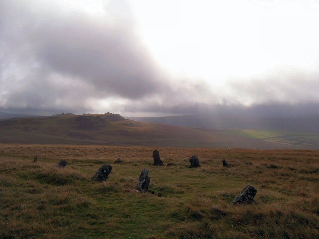
Bedd Arthur ("Arthur's Grave") is a possibly Neolithic hengiform monument in the Preseli Hills in the Welsh county of Pembrokeshire. Thirteen upright stones and at least 2 fallen ones, each around 0.6 metres (2.0 ft) high, form an oval horseshoe with similarities to the earliest form of Stonehenge.
The site has not been excavated and is a scheduled monument.
Read on Wikipedia3 min readCC BY-SA 4.0
Where it sits in time
The site's dated range, placed against world reference points.
The scale is logarithmic: each step to the left is about ten times older than the last.
Article
Bedd Arthur
The shape is not well defined and is generally described as sub-rectangular, but has also been described as a rectangle, a horseshoe, an oval and a pointed ellipse.
DescriptionSources for this section
- Wikipedia (English): Bedd ArthurCC BY-SA 4.0
Sources for this section
- Wikipedia (English): Bedd ArthurCC BY-SA 4.0
Bedd Arthur consists of a barely visible oval bank and ditch, with thirteen standing stones, none higher than 60 centimetres (24 in), arranged inside along with two further fallen stones. The stone layout measures around 20 by 10 metres (66 by 33 ft). The shape is not well defined and is generally described as sub-rectangular, but has also been described as a rectangle, a horseshoe, an oval and a pointed ellipse. Similar arrangements of stones are found at a site known as the 'Churchyard' on Skomer Island, and were adopted at Stonehenge, for which Bedd Arthur has been speculatively suggested as a prototype.
The stones appear to be leaning inwards, suggesting that they were originally placed on the flanks of a mound which has since disappeared. There is also one "truncated end", similar to the portal on some elongated Neolithic burial mounds. There may have been a burial chamber in the middle of the stone setting; it would not be exceptional for the mound itself to have been removed by erosion or grave hunters, as may have happened to the Bedd yr Afanc passage grave on the northern side of Mynydd Preseli.
Research historySources for this section
- Wikipedia (English): Bedd ArthurCC BY-SA 4.0
Sources for this section
- Wikipedia (English): Bedd ArthurCC BY-SA 4.0
The site has not been excavated and is absent from authoritative surveys. Its authenticity as a site, and any relationship to Stonehenge or local sources of stone, are therefore unconfirmed.
Bedd Arthur sits on top of the Preseli ridge and overlooks the rocky outcrop of Carn Menyn, a site that has been suggested as a source for some of the bluestones used at Stonehenge. A 2011 study of a particular group of the Stonehenge bluestones made of rhyolite identified a geological match with an outcrop at Rhosyfelin, 3 kilometres (1.9 miles) north of Bedd Arthur. A 2015 archaeological study at Rhosyfelin, however, failed to identify any signs of quarrying, which appears to support the possibility that the stones were glacial erratics carried east on an ice-flow, rather than evidence of a Neolithic cultural link between the two places.
NameSources for this section
- Wikipedia (English): Bedd ArthurCC BY-SA 4.0
Sources for this section
- Wikipedia (English): Bedd ArthurCC BY-SA 4.0
The name Bedd Arthur means Arthur's Grave. Local folklore claims the site as the burial place of King Arthur, as it does for many sites in the British Isles. Numerous prehistoric sites around Pembrokeshire claim an association with Arthur; in the vicinity of Bedd Arthur there are the Cromlechau Meibion Arthur in Nevern, Garn Arthur and Cerrig Meibion Arthur in Mynachiog-Ddu, and Bwrdd Arthur in Llanboidy.
ConservationSources for this section
- Wikipedia (English): Bedd ArthurCC BY-SA 4.0
Sources for this section
- Wikipedia (English): Bedd ArthurCC BY-SA 4.0
The site is in Eglwyswrw community and is a scheduled monument with legal protection from disturbance. It lies within the Pembrokeshire Coast National Park.
Tradition and region
About this kind of monument
Prehistoric rock art and standing stones of Scotland
Most of the "megalith" records for Britain in the Atlas come from the Scottish register of monuments, and many are not standing stones at all but carved rocks. Cup and ring marks are a form of prehistoric art found along the Atlantic seaboard of Europe, in Ireland, Wales, northern England, Scotland, Brittany, Portugal and Galicia. They consist of a concave depression no more than a few centimetres across, pecked into a rock surface and often surrounded by concentric circles; sometimes a linear channel, called a gutter, leads out from the middle. They occur as petroglyphs on natural boulders and outcrops, and also as an element of megalithic art on worked stones, such as the slab cists of the Food Vessel culture, some stone circles and passage graves, and the capstones at Newgrange.
The richest area is Kilmartin Glen in Argyll, which has the most important concentration of Neolithic and Bronze Age remains in mainland Scotland. There are more than 800 ancient monuments within a ten-kilometre radius of the village, with 150 of them prehistoric, including standing stones, a henge, numerous cists and a linear cemetery of five burial cairns that runs over five kilometres. Several of the cairns, and many natural rocks, are decorated with cup and ring marks.
The meaning of the carvings is unknown. Megalithic art tends to be highly abstract, and its meaning is the subject of much debate. On natural outcrops the marks can be dated only broadly, so the Atlas gives a range from the Neolithic to the Bronze Age; on a worked stone of a dated monument they are at least as old as the monument.
When visiting, low light brings out the cups best. Please do not chalk or rub the carvings.
Paraphrased from Wikipedia: Cup and ring mark, Wikipedia: Kilmartin Glen, Wikipedia: Megalithic art, Wikipedia: Rock art · CC BY-SA 4.0
From the article
Dated moments in the story
- 2011
A 2011 study of a particular group of the Stonehenge bluestones made of a Rhyolite material identified a geological match with an outcrop at Rhosyfelin, 3 kilometres (1.9 miles) north of Bedd Arthur.
Source - 2015
On the other hand, a 2015 archaeological studies at Rhosyfelin failed to identify any signs of quarrying, which appears to promote the possibility of the stones as glacial erratics carried east on an ice-flow, rather than a Neolithic cultural link between the two places.
Source
Photographs
5 photographs, each with its author and licence
More photographs


Lore
Evidence & Lore
What the sources actually support — and, kept apart, what has been claimed.
What the evidence supports
Dates
Est. 4000–2400 BCEHow this date was established: Type comparisonTypical range for megaliths in United Kingdom; this site has not been dated itself. Megalithic construction in England is placed at c. 4000 BC; the first henges in Britain appear c. 3000 BC and hundreds of smaller stone circles were built c. 2400 BC.Source for this date
Where it stands
United Kingdom
The pin marks the monument itself — its exact point.
- Coordinates
- 51°57′35″ N, 4°43′20″ WFor a GPS or map app: 51.95964, -4.72230
Access is as our sources describe it; we have not visited the site to check.
Nearby
The closest sites in the Atlas, by straight line.
 Carn Bica, SW of Penygroes4000–800 BCE
 Carn Menyn chambered cairn4000–2500 BCE
- Megalithic mound (tumulus with integral stones)Carn Gwr, Northern Cairn4000–800 BCE
 Carn Gwr, Southern Cairn4000–800 BCE
 Cerrig Meibion Arthur2800–1800 BCE
- Stone row (alignment)Rhos Fach standing stone pair4000–2400 BCE
 Carn Ferched4000–800 BCE
- Menhir (standing stone)Clym Saith Maen2800–1800 BCE


Sources
Every record behind this page, with the link it came from.
3 sources behind this page
- 01Wikidata Q4879007wikidata.org
- 02Source for this dateen.wikipedia.org
- 03Wikipedia: Bedd Arthuren.wikipedia.org
Image files
- Beddarthur standing stone circle, Preseli Mountains - geograph.org.uk - 258436.jpgAndrew HoweyCC BY-SA 2.0
- Bedd Arthur - geograph.org.uk - 301098.jpgGordon HattonCC BY-SA 2.0
- Bedd Arthur and distant mast - geograph.org.uk - 464128.jpgceridwenCC BY-SA 2.0
- Bedd Arthur and Rhestr Gerrig - geograph.org.uk - 464118.jpgceridwenCC BY-SA 2.0
- Bedd yr afanc, looking east-southeast - geograph.org.uk - 404497.jpgceridwenCC BY-SA 2.0
Report a correctionWrong date, name, photograph or source? Tell us and it will be put right.
Lore, kept apart
Legends and claims
These are stories and claims reported by the sources. They are not evidence, and they never stand in for the dating above.
- Tradition
It is one of many sites in the British Isles to be claimed by local folklore as the burial place of King Arthur.
It is one of many sites in the British Isles to be claimed by local folklore as the burial place of King Arthur. The name Bedd Arthur means Arthur's Grave. There are numerous prehistoric sites around Pembrokeshire, claiming an association with Arthur. In the vicinity of Bedd Arthur, there are the Cromlechau Meibion Arthur in Nevern, Garn Arthur and Cerrig Meibion Arthur in Mynachiog-Ddu, and Bwrdd Arthur in Llanboidy
Source
Around this place
The ten nearest sites, by compass
- Carn Bica, SW of Penygroes0.2 km SW
- Carn Menyn chambered cairn1.0 km E
- Carn Gwr, Northern Cairn1.1 km NE
- Carn Gwr, Southern Cairn1.1 km E
- Cerrig Meibion Arthur1.9 km SW
- Rhos Fach standing stone pair2.1 km S
- Carn Ferched2.3 km E
- Clym Saith Maen2.5 km SW
- Foel Feddau Round Cairn2.8 km W
- Foel Trigarn, West Cairn2.9 km NE
Credit
Text, licence and sources
Adapted from the Wikipedia article "Bedd Arthur" (English), licensed CC BY-SA 4.0; authors are listed in the page history. Reused under CC BY-SA 4.0. Read on Wikipedia · Edit history and authors
- Wikipedia (English): Bedd ArthurCC BY-SA 4.0
- Wikidata Q4879007CC0