Ballochroy
Photo Dreamlucca · CC BY-SA 3.0Source file on Wikimedia Commons

Overview
About this site
Overview
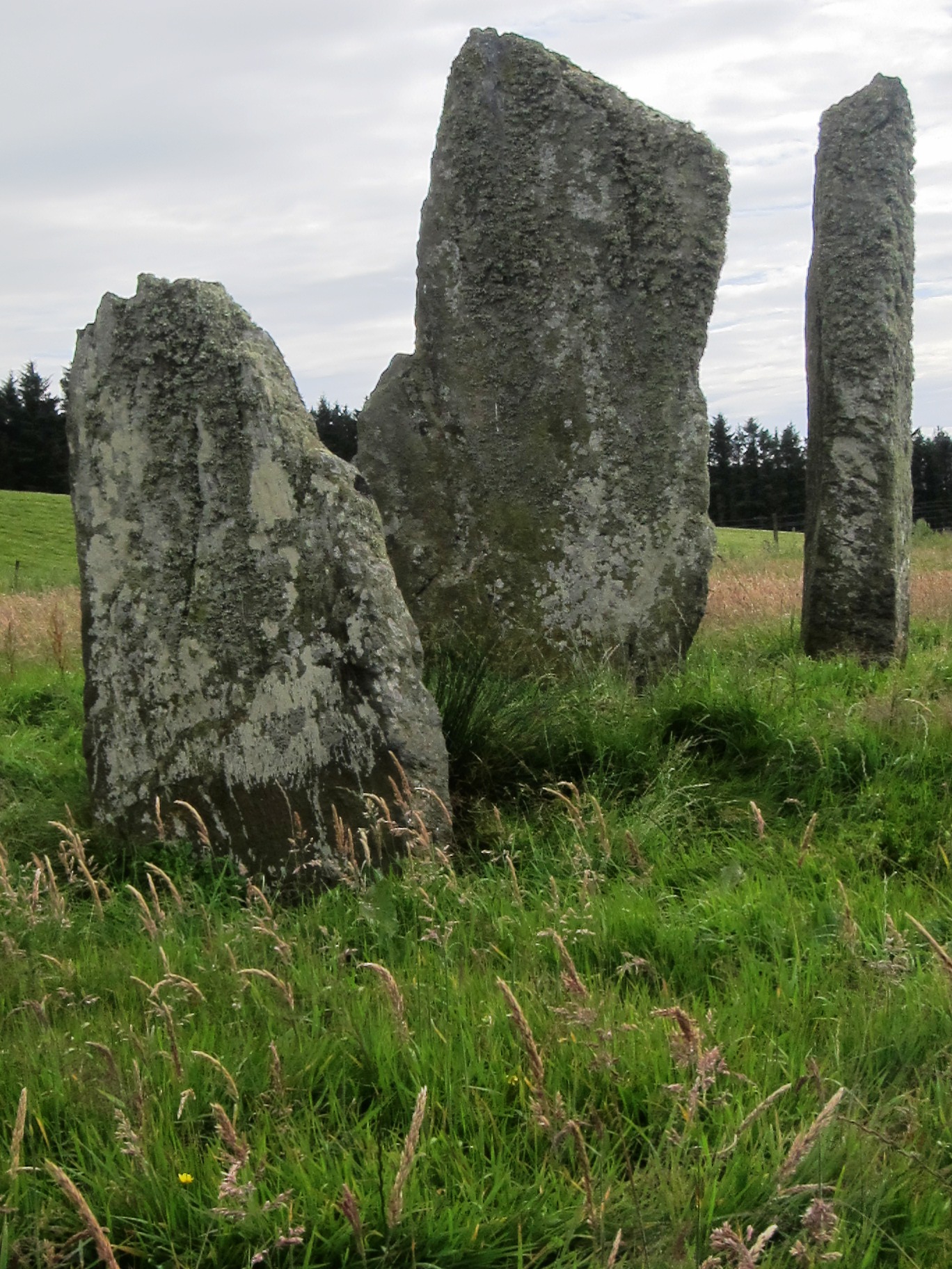
Ballochroy is a megalithic site in Kintyre, on the Argyll peninsula in Scotland. It consists of three vertical stones, side by side, aligned with various land features 7–19 miles (11–31 km) away. The three stones are considered the most spectacular set of megalithic monuments that cluster around South Argyll.
Read on Wikipedia2 min readCC BY-SA 4.0
Article
Ballochroy
DescriptionSources for this section
- Wikipedia (English): BallochroyCC BY-SA 4.0
Sources for this section
- Wikipedia (English): BallochroyCC BY-SA 4.0
The three mica schist stones were measured at 11 ft 6 in, 9 ft 10 in and 6 ft 7 in (3.5, 3.0 and 2.0 m) in height. The smallest stone may have been broken off at the top. The line of stones is oriented north-east to south-west.
The shortest stone also faces across the alignment and points to Beinn a' Chaolais, the southernmost of the three Paps of Jura.
Astronomical alignmentSources for this section
- Wikipedia (English): BallochroyCC BY-SA 4.0
Sources for this section
- Wikipedia (English): BallochroyCC BY-SA 4.0
The flat face of the central stone, at right angles to the alignment, indicates the mountain of Cora Bheinn, on the island of Jura, which is 19 miles (30 km) away. The shortest stone also faces across the alignment and points to Beinn a' Chaolais, the southernmost of the three Paps of Jura. The sunset would have given a warning of the approach of the solstice.
Alexander Thom maintained that the great length between the stones and the features of the distant landscape lent precision to pinpointing the midsummer and winter solstices for ancient observers, indicating that the monument was used as an astronomic calendar. As with many megalithic sites, the current theories concerning the exact use of the stones at Ballochroy are somewhat controversial.
Tradition and region
About this kind of monument
Megalithic complexes
A megalithic complex is a landscape in which several kinds of monument stand together, so that the whole is more than any one piece. Examples include the Carnac stones in Brittany, where alignments, dolmens, tumuli and menhirs lie together; Brú na Bóinne in Ireland, a ritual landscape of at least ninety monuments; the Antequera dolmens in Spain; the Heart of Neolithic Orkney; and the temples of Malta.
At Antequera, the Dolmens of Menga and Viera and the tholos of El Romeral, together with two natural features, a rock outcrop and a mountain range, form the Antequera Dolmens Site, inscribed as a World Heritage Site in 2016. In Orkney the Standing Stones of Stenness and the Ring of Brodgar stand between two lochs, with the chambered cairn of Maeshowe and the village of Skara Brae nearby, as parts of the Heart of Neolithic Orkney.
Such landscapes show how monuments relate to each other and to the land. Newgrange is aligned so that the rising sun at midwinter shines into the chamber. At Carrowmore, the tombs form one of the largest clusters in Ireland in a ritual landscape dominated by the mountain of Knocknarea, which has a great cairn on its summit. How far these relations were intended is debated.
Dating a complex is a matter of dating its parts. A complex usually grew over centuries, and its monuments can differ in age by a thousand years or more.
When visiting, plan to see the whole landscape, from the monuments to the hills and water around them.
Paraphrased from Wikipedia: Megalith, Wikipedia: Carnac stones, Wikipedia: Megalithic Temples of Malta, Wikipedia: Brú na Bóinne, Wikipedia: Antequera Dolmens Site, Wikipedia: Orkney, Wikipedia: Skara Brae, Wikipedia: Maes Howe, Wikipedia: Standing Stones of Stenness, Wikipedia: Carrowmore, Wikipedia: Knocknarea · CC BY-SA 4.0
Photographs
3 photographs, each with its author and licence
More photographs


Where it stands
United Kingdom
The pin marks the monument itself — its exact point.
- Coordinates
- 55°42′35″ N, 5°37′11″ WFor a GPS or map app: 55.70980, -5.61978
Access is as our sources describe it; we have not visited the site to check.
Nearby
The closest sites in the Atlas, by straight line.
 Ballochroy standing stones2800–1800 BCE
- Megalithic mound (tumulus with integral stones)Corriechrevie,cairn4000–800 BCE
- SteleClachan Churchyard, Cross, Cross Slabs & Tombstones
- Menhir (standing stone)Loch Ciaran, standing stone 1430m SW of Achaglass2800–1800 BCE
- Megalithic mound (tumulus with integral stones)Carn Ban,cairn Gigha4000–800 BCE
- Megalithic mound (tumulus with integral stones)Carn na Faire,cairn,Gigha4000–800 BCE
- Menhir (standing stone)Carragh an Tarbert,standing stone 550m NNE of Tarbert,Gigha2800–1800 BCE
 Beacharr,standing stone & long cairn4000–800 BCE

Sources
Every record behind this page, with the link it came from.
2 sources behind this page
- 01Wikidata Q4851831wikidata.org
- 02Wikipedia: Ballochroyen.wikipedia.org
Image files
Report a correctionWrong date, name, photograph or source? Tell us and it will be put right.
Around this place
The ten nearest sites, by compass
- Ballochroy standing stones0.4 km NE
- Corriechrevie,cairn2.2 km NE
- Clachan Churchyard, Cross, Cross Slabs & Tombstones5.3 km NE
- Loch Ciaran, standing stone 1430m SW of Achaglass5.9 km NE
- Carn Ban,cairn Gigha6.1 km W
- Carn na Faire,cairn,Gigha6.9 km W
- Carragh an Tarbert,standing stone 550m NNE of Tarbert,Gigha7.1 km W
- Beacharr,standing stone & long cairn9.5 km S
- Bodach and Cailleach10 km SW
- cairn 800m SW of Ardlamey10 km SW
Credit
Text, licence and sources
Adapted from the Wikipedia article "Ballochroy" (English), licensed CC BY-SA 4.0; authors are listed in the page history. Reused under CC BY-SA 4.0. Read on Wikipedia · Edit history and authors
- Wikipedia (English): BallochroyCC BY-SA 4.0
- Wikidata Q4851831CC0