.JPG/1920px-Audleystown_Court_Cairn_(04).JPG 1920w)
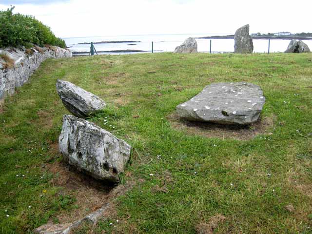
Audleystown Court Cairn
Also known asAudleystown Court Tomb
Datedc. 3900–1564 BCE*
Photo Ardfern · CC BY-SA 3.0Source file on Wikimedia Commons
Overview
About this site
Overview
The Audleystown Court Tomb, also known as Audleystown Court Cairn, is a Neolithic dual court tomb in Ballyculter parish, near the southern shore of Strangford Lough in County Down, Northern Ireland. It was built around 3900–3500 BCE.
Its double courtyard and double burial chamber layout is unique to Ireland. It was first excavated by the archaeologist A.E. Collins in 1952.
Read on Wikipedia3 min readCC BY-SA 4.0
Age sources
Sources disagree on the age of this site
Sources do not agree on how old this site is. Each claim is listed with where it comes from; the mainstream reading is marked.
Range across all claimsc. 3900–1564 BCE*
MeasuredWhat this badge means
A physical measurement of this site: a radiocarbon date, a tree-ring count, a luminescence date, or a record that can itself be dated.
- 1802–1564 BCERadiocarbon dating6 radiocarbon dates in the p3k14c database (Bird et al. 2022, Scientific Data 9:27 (p3k14c radiocarbon database)) between 602 and 3774 BP; the range shown is thSource: p3k14c.org
- 3900–3500 BCEWikipedia: Audleystown Court Tomb (infobox)Source: en.wikipedia.org
Where it sits in time
The site's dated range, placed against world reference points.
The scale is logarithmic: each step to the left is about ten times older than the last.
Article
Audleystown Court Cairn
Court tombs typically have a single courtyard and one gallery of compartmentalized burial areas, usually located at the wide end of the cairn.
DescriptionSources for this section
- Wikipedia (English): Audleystown Court TombCC BY-SA 4.0
Sources for this section
- Wikipedia (English): Audleystown Court TombCC BY-SA 4.0
Court tombs typically have a single courtyard and one gallery of compartmentalized burial areas, usually located at the wide end of the cairn. In a dual-court tomb a court and a gallery are placed at each end of the cairn, as at Audleystown and Cohaw.
The survey determined that the tomb has a double open courtyard, two burial chambers and a trapezoid shaped cairn. The monument is orientated northeast–southwest, with the wider end facing southwest. It is faced with a drystone wall of standing shale stones, which were originally covered by shale and earth. Each open court is connected to a gallery with equal-sized burial chambers.
ExcavationsSources for this section
- Wikipedia (English): Audleystown Court TombCC BY-SA 4.0
Sources for this section
- Wikipedia (English): Audleystown Court TombCC BY-SA 4.0
In 1952, as part of the Archaeological Survey of Northern Ireland, A.E.P. ('Pat') Collins conducted the first excavation of the tomb and published his findings in 1954. Further excavations supervised by Collins were conducted from October, 1956 to May, 1957.
The remains of 34 people were found in the burial chambers. They were a combination of cremated, partially-burnt and unburnt bones, and two thirds of the bones were unburnt and defleshed, which is unusual. The remains were primarily of women and children and were of disarticulated bones, together with some animal bones. Pottery sherds and worked flint were also found. The pottery included pieces of at least three bowls made with a smooth, corky fabric and a few pieces of Carrowkeel ware.
ConservationSources for this section
- Wikipedia (English): Audleystown Court TombCC BY-SA 4.0
Sources for this section
- Wikipedia (English): Audleystown Court TombCC BY-SA 4.0
The Ministry of Finance assumed guardianship of the site and declared it an ancient monument. After the 1952 excavation the burial galleries were filled with sand to protect the monument.
In 1958 a project to preserve the walls of the cairn was undertaken by a group led by Collins. The courtyard areas were taken down to their original ground levels. Large Silurian slabs that had previously been robbed from the cairn were located in nearby fields and placed back in their original positions, and missing standing stones from the galleries were replaced with similarly sized stones. Where no suitable stones were available, the walls were repaired with a combination of drystone and concrete. The cairn was rebuilt up to what was determined to be its original height with a combination of stones and earth from the site.
ContextSources for this section
- Wikipedia (English): Audleystown Court TombCC BY-SA 4.0
Sources for this section
- Wikipedia (English): Audleystown Court TombCC BY-SA 4.0
Court tombs are among the earliest megalithic monuments in Ireland and Scotland. During the period 3900 to 3500 BCE more than 390 court cairns were built in Ireland and over 100 in south-west Scotland. They are identified by an open, uncovered courtyard connected to one or more roofed burial chambers. Many monuments of this kind were built in several phases and were later reused in the Early Bronze Age.
Tradition and region
About this kind of monument
Irish and Scottish court tombs
A court cairn or court tomb is a type of chambered cairn identified by an open, uncovered courtyard connected to one or more roofed burial chambers. In the period 3900 to 3500 BCE more than 390 court cairns were built in Ireland and over 100 in south-west Scotland, where they are called Clyde cairns or Clyde-Carlingford cairns. The Clyde cairns are generally considered the earliest chambered cairns in Scotland, and they are distributed from the Solway Firth area north to the southern Hebrides. Many monuments were built in several phases and later reused in the Early Bronze Age.
The courtyard is oval or circular, with U-shaped and semicircular courts also known, and its boundary is typically lined with large standing stones. A narrow stone-lined entry leads from the court into the roofed chambers. At Creevykeel in County Sligo, the first court cairn excavated in Ireland, Harvard archaeologists worked in 1935 and concluded that the Neolithic in Ireland began in 3900 BCE, more than a hundred years before the first appearance of court tombs, and that court tombs were widely reused in the Early Bronze Age. Excavations at court tombs have yielded cremated and unburnt human bone and round-bottomed pottery.
In Scotland, Cairnholy in Dumfries and Galloway is the site of two chambered tombs of the Clyde type on a hillside overlooking Wigtown Bay, 4 kilometres east of Carsluith; the two lie within 150 metres of each other.
Court tombs are dated by radiocarbon dates of the bone they contain and the pottery.
When visiting, look for the standing stones of the forecourt and the entrance to the chambers.
Paraphrased from Wikipedia: Court cairn, Wikipedia: Chambered cairn, Wikipedia: Cairn Holy, Wikipedia: Passage grave · CC BY-SA 4.0
From the article
Dated moments in the story
- 3500 BCE
The tomb was built around 3900–3500 BCE.
Source - 3500 BCE
During the period 3900–3500 BCE, more than 390 court cairns were constructed in Ireland and over 100 in southwest Scotland.
Source - 1952
Collins in 1952. The Audleystown court tomb has a double courtyard-double burial chamber layout, which is unique to Ireland.
Source - 1952
In 1952, as part of the Archaeological Survey of Northern Ireland, A.E.P ('Pat') Collins, conducted the first archeological excavation of the Audleystown tomb and published his findings in 1954. The Ministry of Finance assumed guardianship of the site and declared it an ancient monument.
Source - 1952
After the 1952 excavation, the burial galleries were filled with sand to protect the monument.
Source - 1956
From October, 1956 to May, 1957, further excavations was conducted at the site, supervised by Collins.
Source - 1958
In 1958, a project to preserve the walls of the cairn was undertaken by a group led by Collins.
Source
Photographs
8 photographs, each with its author and licence
More photographs
Lore
Evidence & Lore
What the sources actually support — and, kept apart, what has been claimed.
What the evidence supports
Dates
1802–1564 BCEHow this date was established: Radiocarbon dating6 radiocarbon dates in the p3k14c database (Bird et al. 2022, Scientific Data 9:27 (p3k14c radiocarbon database)) between 602 and 3774 BP; the range shown is the middle half of the measurements; uncalibrated ages, shown as calendar years with the conventional BP + 1950 conversion.Source for this date
Where it stands
United Kingdom
The pin marks the monument itself — its exact point.
- Coordinates
- 54°22′40″ N, 5°35′49″ WFor a GPS or map app: 54.37781, -5.59698
Access is as our sources describe it; we have not visited the site to check.
Nearby
The closest sites in the Atlas, by straight line.


Sources
Every record behind this page, with the link it came from.
3 sources behind this page
- 01Wikidata Q758951wikidata.org
- 02Source for this datep3k14c.org
- 03Wikipedia: Audleystown Court Cairnen.wikipedia.org
Image files
- Audleystown Court Cairn (04).JPGArdfernCC BY-SA 3.0
- Audleystown Court Cairn (07).JPGArdfernCC BY-SA 3.0
- Audleystown Double Horned Court Cairn - panoramio (1).jpgPeter Moore (Moorso)CC BY-SA 3.0
- Audleystown Double Horned Court Cairn - panoramio (2).jpgPeter Moore (Moorso)CC BY-SA 3.0
- Audleystown Court Tomb - geograph.org.uk - 3542805.jpgEric JonesCC BY-SA 2.0
- Audleystown Court Tomb from the east - geograph.org.uk - 3547406.jpgEric JonesCC BY-SA 2.0
- Ivy, County Down, August 2009.JPGArdfernCC BY-SA 3.0
- Lichen, County Down, August 2009.JPGArdfernCC BY-SA 3.0
Report a correctionWrong date, name, photograph or source? Tell us and it will be put right.
Around this place
The ten nearest sites, by compass
Credit
Text, licence and sources
Adapted from the Wikipedia article "Audleystown Court Tomb" (English), licensed CC BY-SA 4.0; authors are listed in the page history. Reused under CC BY-SA 4.0. Read on Wikipedia · Edit history and authors
- Wikipedia (English): Audleystown Court TombCC BY-SA 4.0
- Wikidata Q758951CC0