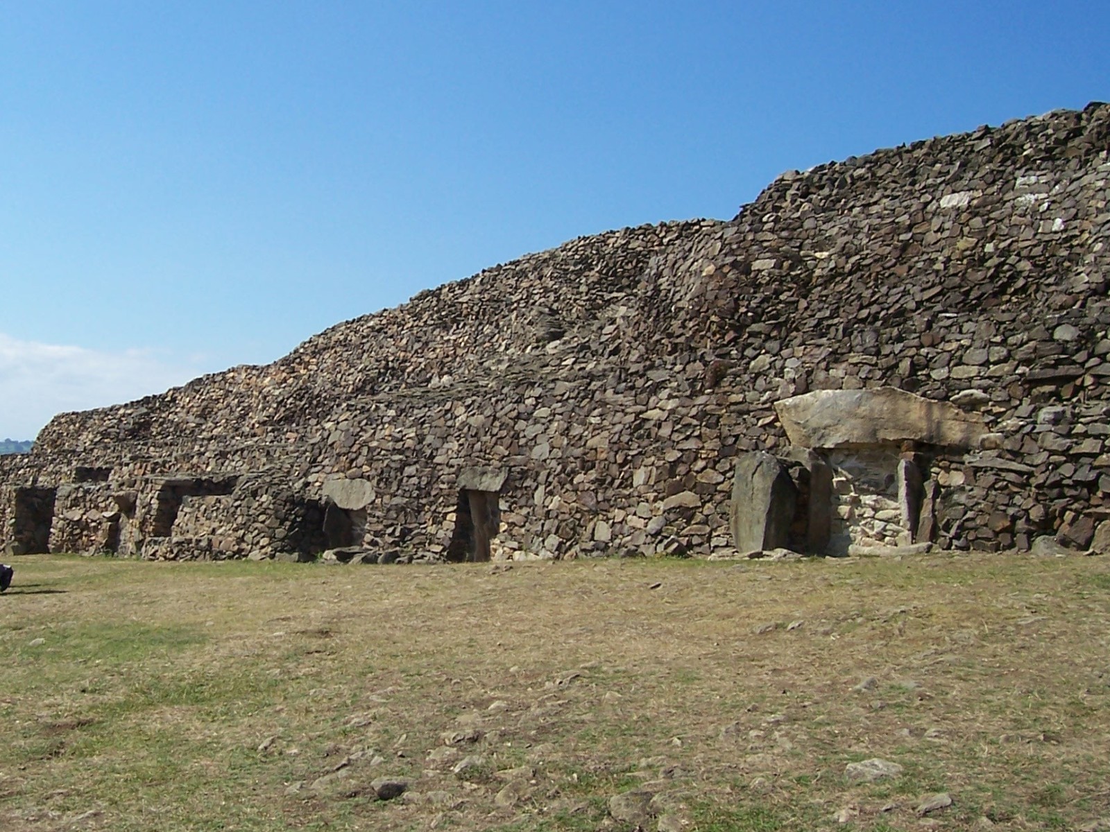
Barnenez
Datedc. 4500–4000 BCE
Photo No machine-readable author provided. NewPapillon assumed (based on copyright claims). · CC BY-SA 3.0Source file on Wikimedia Commons
Overview
About this site
What the sources say
The Cairn of Barnenez (also: Barnenez Tumulus, Barnenez Mound; in Breton Karn Barnenez; in French: Cairn de Barnenez or Tumulus de Barnenez) is a Neolithic monument located near Plouezoc'h, on the Kernéléhen peninsula in northern Finistère, Brittany, France. It dates to the early Neolithic, around 4000 BC. Along with the Tumulus of Bougon and Locmariaquer megaliths, also located in Great West France, it is one of the earliest megalithic monuments in Europe and one of the oldest man-made structures in the world. It is also remarkable for the presence of megalithic art.
Read on Wikipedia7 min readCC BY-SA 4.0
Age sources
How old this site is, and who says so.
Range across all claimsc. 4500–4000 BCE
- 4000 BCEWikipedia: BarnenezSource: en.wikipedia.org
- 4500 BCEWikidata inceptionSource: wikidata.org
Where it sits in time
The site's dated range, placed against world reference points.
The scale is logarithmic: each step to the left is about ten times older than the last.
The full article
Barnenez: the whole story
In briefSources for this section
- Wikipedia (English): BarnenezCC BY-SA 4.0
Sources for this section
- Wikipedia (English): BarnenezCC BY-SA 4.0
The Cairn of Barnenez, also known as the Barnenez Tumulus or Mound, is a Neolithic monument near Plouezoc'h, on the Kernéléhen peninsula in northern Finistère, Brittany, France. It dates to the early Neolithic, around 4000 BC. With the Tumulus of Bougon and the Locmariaquer megaliths, it is one of the earliest megalithic monuments in Europe and one of the oldest man-made structures in the world. It is also remarkable for its megalithic art.
Today the cairn is 72 m long, up to 25 m wide and over 8 m high, built of 13,000 to 14,000 tons of stone. It has steep facades and a stepped profile, and it contains 11 chambers, each entered by its own passage. The mound consists of relatively small blocks, with only the chambers being truly megalithic. It overlooks the Bay of Morlaix, probably a fertile coastal plain at the time it was built.
Radiocarbon dates indicate that the first phase was erected between 4850 and 4250 BC and the second phase between 4450 and 4000 BC. In the first phase a slightly trapezoidal mound of 32 m by 9 to 13 m was built, with 5 chambers and a double kerb, favouring dolerite. In the second, an extension with six further chambers was added in the west, and the first cairn was enveloped in a wider and taller structure, with more granite used. Estimates suggest the first cairn alone would have taken 200 workers three months to erect.
The 11 chambers are of the type the French call dolmen à couloir, or passage grave, built of large slabs of slate and granite. Each is reached from the southeast by a long narrow passage (7–12 m long), and the passages run parallel. In nine cases the passages lead to corbelled chambers, and in one the corbel vault sits on the ground, forming a true tholos. Engraved symbols in several chambers and passages show bows, axes, wave symbols or snakes and a repeated U-shaped sign, and one recurring symbol is sometimes read as the so-called 'Dolmen Goddess'.
The cairn was first mapped in 1807 and recognised scientifically at a congress in Morlaix in 1850. Privately owned until the 1950s, it was used as a quarry for paving stones, which threatened to destroy it until several chambers were discovered in the 1950s and the local community took control. It was restored between 1954 and 1968. Pottery shows reuse in the Bronze Age, in the 3rd millennium BC. Similar monuments are known at 22 other locations in France and on Jersey.
Radiocarbon dates indicate that the first phase of the monument was erected between 4850 and 4250 BC, and the second phase between 4450 and 4000 BC.
History and datingSources for this section
- Wikipedia (English): BarnenezCC BY-SA 4.0
Sources for this section
- Wikipedia (English): BarnenezCC BY-SA 4.0
Dates
Radiocarbon dates indicate that the first phase of the monument was erected between 4850 and 4250 BC, and the second phase between 4450 and 4000 BC.
Secondary use
Pottery found in and around the monument indicates that it underwent a period of reuse in the Bronze Age, in the 3rd millennium BC.
Recognition as an ancient monument
The cairn was first mapped in 1807, in the context of the Napoleonic cadaster. Its first scientific recognition took place in the context of an academic congress in Morlaix in 1850, when it was classified as a tumulus.
Quarry damage
Privately owned until the 1950s, the cairn was used as a quarry for paving stones. This activity, which threatened to destroy the monument, was only halted after the discovery of several of its chambers in the 1950s. The local community then took control of the site.
Restoration and excavation
The cairn was restored between 1954 and 1968. At the same time, vegetation was removed from the mound and systematic excavation took place in and around the monument.
DescriptionSources for this section
- Wikipedia (English): BarnenezCC BY-SA 4.0
Sources for this section
- Wikipedia (English): BarnenezCC BY-SA 4.0
The mound
Today, the Barnenez cairn is 72 m long, up to 25 m wide, and over 8 m high. It is built of 13,000 to 14,000 tons of stone. It contains 11 chambers entered by separate passages. The mound has steep facades and a stepped profile. Several internal walls either represent earlier facades or served the stability of the structure. The cairn consists of relatively small blocks of stone, with only the chambers being truly megalithic in character.
The monument overlooks the Bay of Morlaix, probably a fertile coastal plain at the time of its erection.
Construction phases
The monument is the result of at least two phases of building.
Cairn 1, before 4500 BC
In a first phase, a slightly trapezoidal mound of 32 m by 9 to 13 m was erected. It contained 5 chambers and was surrounded by a double kerb. The first phase favoured the use of dolerite.
Cairn 2, c. 4200 – c. 4000 BC
In a second phase, an extension with six further chambers was added in the west. At the same time, Cairn 1 was enveloped in a wider and taller structure; its passages had to be extended. More granite was used in this phase.
The chambers
The 11 chambers of the Barnenez cairn are of the type known as Dolmen à couloir in French archaeological terminology. The term translates roughly as "passage grave". They are built of large slabs of slate and granite. Originally, all the chambers were entirely enclosed by the mound. The fact that several of them are partially exposed now is the result of modern quarrying.
Each of the 11 chambers is reached from the southeast via a long narrow passage (7–12 m long). They are arranged parallel to each other. Shapes and construction techniques differ slightly.
In nine cases, narrow passages lead to corbelled chambers. Normally, the corbel vault rests on orthostats, in one chamber it actually sits on the ground, forming a true tholos. The passages have slab-built or dry stone walls and are covered with slabs. One of the chambers has a dry-stone vaulted ante-chamber.
Logistics
One cubic metre of the Barnenez cairn contains 1,500 kg of stone. It is estimated that the quarrying, fashioning, transport and construction of such an amount represents about four work days for a single worker (assuming a 10-hour day). The original monument, Cairn 1, had a volume of about 2,000 cubic metres; it is built of 1,000 tons of granite and 3,000 tons of dolerite. It would thus have required 15,000 to 20,000 working days; in other words, it would have taken 200 workers three months to erect Cairn 1 alone. In its final form, the Barnenez mound is nearly three times as big as the first phase.
Engraved symbols
Engraved symbols occur in several of the chambers and passages. They depict bows, axes, wave symbols or snakes and a repeated U-shaped sign. One of the carved slabs is in secondary use; it was originally part of a different structure, an interesting parallel to the situation in several other such monuments, including Gavrinis.
The symbols on the engraved blocks resemble those found in other megalithic monuments in Brittany; in broader terms they belong to the cultural phenomenon described as megalithic art. One of the recurring symbols is sometimes interpreted as an anthropomorphic depiction (the so-called "Dolmen Goddess").
Finds
Material from the original period of use
Only Cairn 2, namely chambers A, C and D, contained Neolithic finds at the time of excavation. They included pottery, polished stone axes (of dolerite), flint blades and arrowheads.
Bronze Age pottery
Pottery shards found outside the monument indicate that it was reused in the Bronze Age (3rd millennium BC). A copper dagger and a barbed arrowhead are of Chalcolithic date.
Comparable monumentsSources for this section
- Wikipedia (English): BarnenezCC BY-SA 4.0
Sources for this section
- Wikipedia (English): BarnenezCC BY-SA 4.0
Similar, possibly contemporary, monuments are known at 22 other locations in France and on Jersey. Breton examples are Larcuste-Colpo, Le Bono, Petit Mont, Ty-Floc´h, Gavrinis, Île Carn, Ploudalmézeau and Guennoc (I´ile Gaignoc – sometimes spelt Guénioc) off the shore at Landéda. Those located on islands are generally better preserved. Chamber 3 B at Guennoc contains a small standing stone near the entrance.
ExhibitionSources for this section
- Wikipedia (English): BarnenezCC BY-SA 4.0
Sources for this section
- Wikipedia (English): BarnenezCC BY-SA 4.0
An exhibition in the modern entrance building explains the results of scientific excavation and displays some objects from the site.
How this page was madeSources for this section
- Wikipedia (English): BarnenezCC BY-SA 4.0
Sources for this section
- Wikipedia (English): BarnenezCC BY-SA 4.0
The summary at the top of this page was written by Claude Sonnet 5.5 (2026-11-06) from the cited Wikipedia article “Barnenez”. The numbers in it were checked automatically against the source text. The rest of the page is the article itself, the structured records and computed distances.
Tradition and region
About this kind of monument
French dolmens
France is the dolmen country of Europe: the Dolmen de Bagneux at Saumur is the largest of some 4,500 dolmens scattered across 60 French departments, and one of the largest in Europe. A dolmen is a single-chamber megalithic tomb with two or more upright stones carrying a great capstone. Most date to the Late Neolithic, about 4000 to 3000 BCE, and many were covered with earth or smaller stones to form a mound.
Some of the oldest megalithic monuments in Europe are in western France. The Cairn of Barnenez in Finistère dates to the early Neolithic, around 4000 BCE, and with the Tumulus of Bougon and the Locmariaquer megaliths it is among the earliest megalithic monuments in Europe; it also has megalithic art. La Roche-aux-Fées near Essé in Ille-et-Vilaine is a covered corridor about 20 metres long, built of some 48 blocks, the heaviest around 45 tonnes, and divided into two chambers. It is thought to date from 3000 to 2500 BCE, and its entrance is aligned on sunrise at the winter solstice.
Folklore: the name of La Roche-aux-Fées, "the fairies' rock", comes from a legend that fairies placed the stones. Such stories are traditions about the monuments, not evidence of how they were built.
Because the Atlas draws on national inventories, its French records include many small and ruined dolmens, often reduced to a capstone resting on a few supports. Dates rest on the typology of the monument and, where a dolmen has been excavated, on radiocarbon dating of material from the chamber.
When visiting, look for the capstone and its supports, for the low rise of the old mound around the stones, and for the direction in which the entrance faces.
Paraphrased from Wikipedia: Dolmen, Wikipedia: Dolmen de Bagneux, Wikipedia: La Roche-aux-Fées, Wikipedia: Barnenez, Wikipedia: Carnac stones · CC BY-SA 4.0
From the article
Dated moments in the story
- 4000 BCE
It dates to the early Neolithic, around 4000 BC.
Source - 1850
Its first scientific recognition took place in the context of an academic congress in Morlaix in 1850, when it was classified as a tumulus. Privately owned until the 1950s, the cairn was used as a quarry for paving stones.
Source - 1954
The local community then took control of the site. The cairn was restored between 1954 and 1968. At the same time, vegetation was removed from the mound and systematic excavation took place in and around the monument.
Source
See it in 3D
An interpretive reconstruction of the monument, standing on the real ground at its exact point, under the sun for that place and season. Drag to look around it.

The reconstruction is ours, not a survey: it shows what a monument of this type looks like, at the size the record gives for this one.
Photographs
8 photographs, each with its author and licence
More photographs
Lore
Evidence & Lore
What the sources actually support — and, kept apart, what has been claimed.
What the evidence supports
Dates
Est. 4000–3000 BCEHow this date was established: Type comparisonTypical range for dolmens in France; this site has not been dated itself. Most dolmens date from the Late Neolithic period (4000-3000 BCE).Source for this date
Where it stands
France
The pin marks the monument itself — its exact point.
- Coordinates
- 48°40′03″ N, 3°51′31″ WFor a GPS or map app: 48.66750, -3.85861
Access is as our sources describe it; we have not visited the site to check.
Nearby
The closest sites in the Atlas, by straight line.


Sources
Every record behind this page, with the link it came from.
3 sources behind this page
- 01Wikidata Q808456wikidata.org
- 02Source for this dateen.wikipedia.org
- 03Wikipedia: Barnenezen.wikipedia.org
Image files
- Barnenez front2.jpgNo machine-readable author provided. NewPapillon assumed (based on copyright claims).CC BY-SA 3.0
- Breizh 29 - Plouezoc'h - cairn barnenez, tu norzh B.JPGFarz brujunetCC BY-SA 3.0
- Breizh 29 - Plouezoc'h - cairn barnenez, tu kreisteiz C.JPGFarz brujunetCC BY-SA 3.0
- Bay of Morlaix from the Cairn of Barnenez.JPGFlorent LsCC BY-SA 3.0
- Breizh 29 - Plouezoc'h - cairn barnenez, tu norzh A.JPGFarz brujunetCC BY-SA 3.0
- Barnenez.P1030151.jpgBautschCC0
- B 1 Cairn von Barnenez C.jpgGerhard HauboldCC BY-SA 3.0
- Barnenez.P1030163.jpgBautschCC0


Report a correctionWrong date, name, photograph or source? Tell us and it will be put right.
Around this place
The ten nearest sites, by compass
Credit
Text, licence and sources
Text from the Wikipedia article "Barnenez" (English), licensed CC BY-SA 4.0; authors are listed in the page history. Reused under CC BY-SA 4.0. Read on Wikipedia · Edit history and authors
- Wikipedia (English): BarnenezCC BY-SA 4.0
- Wikidata Q808456CC0