Gallery grave (allée couverte)
allée couverte de Ville-Menot
DatedEst. 4500–3300 BCE
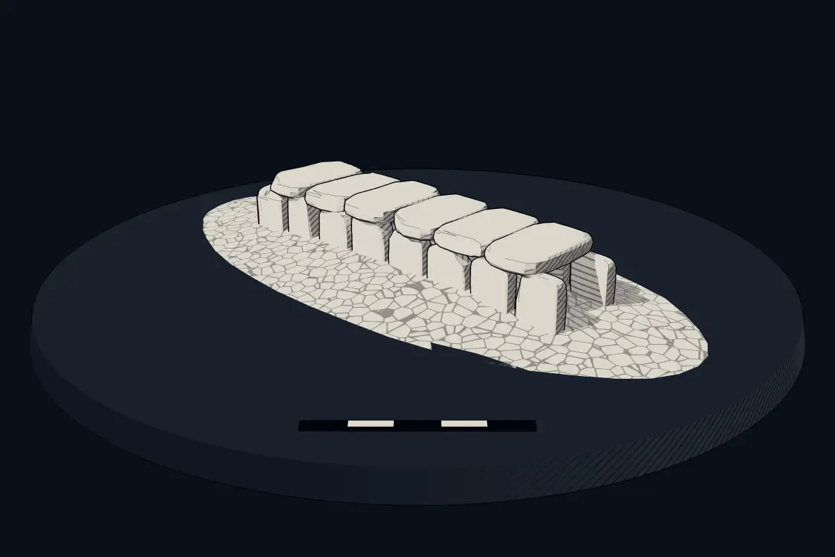
No licensed photograph yetWe have no photograph we may publish for this site, so the interpretive 3D view leads instead.
Overview
About this site
Overview
The allée couverte de Ville-Menot is a gallery grave at Gomené in the département of Côtes-d'Armor, France. It is dated by typological estimate to between 4500 and 3300 BCE.
The gallery is about 10.50 m long, trapezoidal in plan, and still carries three capstones.
Read on Wikipedia2 min readCC BY-SA 4.0
Where it sits in time
The site's dated range, placed against world reference points.
The scale is logarithmic: each step to the left is about ten times older than the last.
Article
allée couverte de Ville-Menot
The gallery is bounded by at least twelve orthostates, which still support three capstones.
DescriptionSources for this section
Sources for this section
The gallery measures about 10.50 m in length and has the form of an elongated trapezium. It contains a single chamber 1.50 m wide at the entrance and 1.10 m wide at the far end, with a height beneath the slabs of less than 0.80 m.
The gallery is bounded by at least twelve orthostates, which still support three capstones. These three slabs have been trimmed to improve their fit, and the middle one bears clearly visible traces of cutting. A fourth capstone, probably, lies on the ground beside the gallery. A menhir of almost circular section is visible in the south-west corner of the gallery.
ContextSources for this section
Sources for this section
A gallery grave is a megalithic tomb built mainly in the Neolithic in which the main gallery is entered directly, with no antechamber or passage in front. The French term allée couverte means 'covered alley'. Gallery graves may be covered with an earthen mound or a cairn.
According to the archaeologist T. Douglas Price, the gallery grave was a form of community burial site, and those placed in it were most likely members of the same family or hamlet.
Tradition and region
About this kind of monument
Gallery graves (allées couvertes)
A gallery grave is a megalithic tomb built mainly in the Neolithic in which the main gallery is entered directly, with no antechamber or passage in front. The French term is allée couverte, "covered alley". There are at least four major types: complex, transepted, segmented and wedge-shaped, and they may be covered with an earthen mound or a cairn.
According to the archaeologist T. Douglas Price, the gallery grave was a form of community burial site. Those placed in it were most likely members of the same family or hamlet, and the burial probably served to reinforce community. Gallery graves are found at sites in the Loire valley of France, in south-west Great Britain and in Ireland, and it is thought that the builders had cultural links with one another.
In Germany the Wartberg culture of northern Hesse, southern Lower Saxony and western Thuringia, which lasted from about 3600 to 2800 BCE, built stone gallery graves. In Britain and Ireland the same idea appears in the Irish wedge tombs and the Severn-Cotswold tombs of Wales and south-west England.
Along with the dolmen and passage grave, the gallery grave is the most common megalithic tomb in western Europe. Most were built in the Neolithic, but some date to the Middle and Late Bronze Age. Dating is difficult, since a tomb built in the Late Neolithic or Early Bronze Age may have been reopened and used for burials until the Late Bronze Age.
When visiting, look for the long rectangular chamber and its capstones.
Paraphrased from Wikipedia: Gallery grave, Wikipedia: Allée couverte, Wikipedia: Wartberg culture · CC BY-SA 4.0
From the article
Dated moments in the story
- 2004
Loïc Langouët, Les mégalithes de l'arrondissement de Dinan, Institut Culturel de Bretagne, 2004, 62 p.
Source
Lore
Evidence & Lore
What the sources actually support — and, kept apart, what has been claimed.
What the evidence supports
Dates
Est. 4500–3300 BCEHow this date was established: Type comparisonTypical range for gallery graves in France; this site has not been dated itself. The gallery graves (allees couvertes) of north-west France belong to the tradition of the Carnac stones which date from 4500-3300 BC.Source for this date
Where it stands
France
The pin marks the monument itself — its exact point.
- Coordinates
- 48°09′39″ N, 2°29′55″ WFor a GPS or map app: 48.16085, -2.49859
Access is as our sources describe it; we have not visited the site to check.
Nearby
The closest sites in the Atlas, by straight line.
- Menhir (standing stone)Le Vau-Janot2800–1800 BCE
- Menhir (standing stone)Menhir von Camblot2800–1800 BCE
- Menhir (standing stone)Menhirs du Perfaux2800–1800 BCE
- Menhir (standing stone)menhir de la Coudre2800–1800 BCE
 Allée couverte des Meurtiaux4000–3000 BCE
 allée couverte de La Roche aux Fées de la Brousse4500–3300 BCE
 dolmen du Carouge4000–3000 BCE
- Menhir (standing stone)menhir de la Pierre Longue2800–1800 BCE


Sources
Every record behind this page, with the link it came from.
2 sources behind this page
- 01Wikidata Q30740259wikidata.org
- 02Source for this dateen.wikipedia.org
Report a correctionWrong date, name, photograph or source? Tell us and it will be put right.
Around this place
The ten nearest sites, by compass
- Le Vau-Janot2.0 km NE
- Menhir von Camblot2.4 km SE
- Menhirs du Perfaux12 km N
- menhir de la Coudre14 km N
- Allée couverte des Meurtiaux19 km N
- allée couverte de La Roche aux Fées de la Brousse19 km N
- dolmen du Carouge20 km N
- menhir de la Pierre Longue21 km N
- Menhirs de Saint-Mirel21 km N
- Dolmen des Pierres-Gouffier22 km SE
Credit
Text, licence and sources
Adapted from the Wikipedia article "Allée couverte de Ville-Menot" (French), licensed CC BY-SA 4.0; authors are listed in the page history. Reused under CC BY-SA 4.0. Read on Wikipedia · Edit history and authors