
Gallery grave (allée couverte)
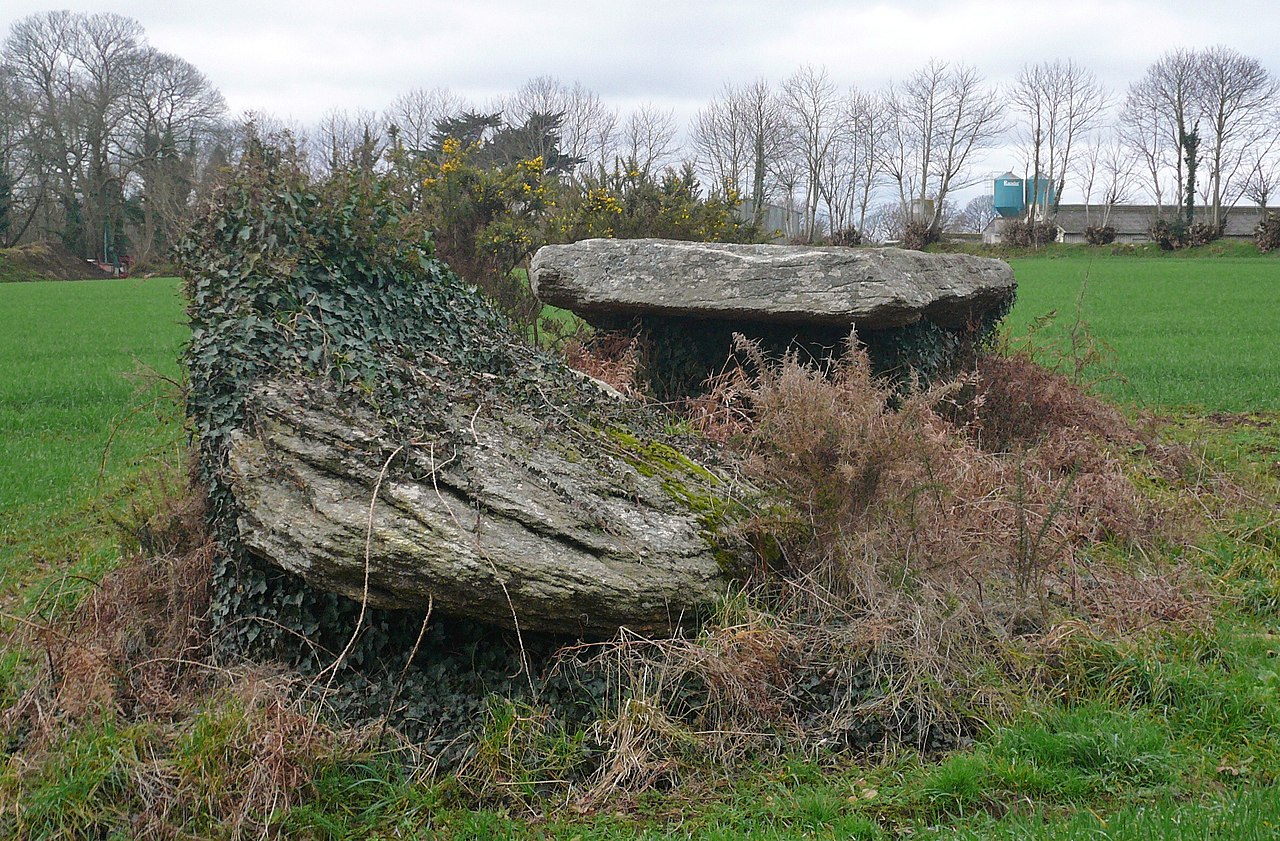
Allée couverte de Kermaout
DatedEst. 4500–3300 BCE
Photo Erwan Corre · CC BY-SA 4.0Source file on Wikimedia Commons

Overview
About this site
What the sources say
L’allée couverte de Kermaout est une allée couverte située sur la commune de Bannalec dans le département du Finistère en France.
Article in FrenchRead on Wikipedia3 min readCC BY-SA 4.0
Where it sits in time
The site's dated range, placed against world reference points.
The scale is logarithmic: each step to the left is about ten times older than the last.
The full article
Allée couverte de Kermaout: the whole story
In briefSources for this section
- Wikipedia (French): Allée couverte de KermaoutCC BY-SA 4.0
Sources for this section
- Wikipedia (French): Allée couverte de KermaoutCC BY-SA 4.0
Allée couverte de Kermaout is a gallery grave on the commune of Bannalec in the département of Finistère, France. Its date is estimated from its type to 4500 BCE to 3300 BCE. Gallery graves were built mainly in the Neolithic and are entered directly, without an antechamber or passage in front.
The monument is a covered alley set into a bank and oriented northwest/southeast. It is built chiefly from micaschist slabs and extends for 8 m. Its covering table measures 2,50 m by 1 m and is 0,20 to 0,40 m thick. Six pillars support the structure, while the height beneath the slab does not exceed 0,85 m.
Allée couverte de Kermaout was first mentioned in 1877, when it was already partly ruined. It has been listed as a monument historique since 4 November 1975. A block of quartz near the eastern entrance appears not to form part of the monument.
A local tradition says that the site was frequented by lutins, and the field containing it is named Park-Korrigan, meaning the parcel of the Korrigans. More generally, gallery graves were often community burial places, probably used for people from the same family or hamlet, and are found in the Loire valley of France, south-west Great Britain and Ireland.
No English Wikipedia article exists for it; the full text below is the French article "Allée couverte de Kermaout", shown in the original language.
Summary in EnglishSources for this section
- Wikipedia (French): Allée couverte de KermaoutCC BY-SA 4.0
Sources for this section
- Wikipedia (French): Allée couverte de KermaoutCC BY-SA 4.0
Allée couverte de Kermaout is a gallery grave (allée couverte) in Bannalec, France. Wikidata describes it as: gallery grave in Bannalec, France. A typological estimate: 4500 BCE to 3300 BCE. No English Wikipedia article exists for it; the full text below is the French article "Allée couverte de Kermaout", shown in the original language.
HistoriqueSources for this section
- Wikipedia (French): Allée couverte de KermaoutCC BY-SA 4.0
Sources for this section
- Wikipedia (French): Allée couverte de KermaoutCC BY-SA 4.0
L'édifice est mentionné pour la première fois en 1877, il est déjà en partie ruiné. Il est classé en tant que monument historique depuis le 4 novembre 1975.
DescriptionSources for this section
- Wikipedia (French): Allée couverte de KermaoutCC BY-SA 4.0
Sources for this section
- Wikipedia (French): Allée couverte de KermaoutCC BY-SA 4.0
C'est une allée couverte encastrée dans un talus. Elle est orientée nord-ouest/sud-est. Elle est principalement constituée de dalles en micaschiste. Elle s'étire sur 8 m de longueur. Elle est composée d'une table de couverture (2,50 m sur 1 m pour une épaisseur de 0,20 à 0,40 m) et de six piliers. La hauteur sous dalle ne dépasse pas 0,85 m. Un bloc de quartz près de l'entrée orientale du monument ne semble pas faire partir de l'ensemble.
FolkloreSources for this section
- Wikipedia (French): Allée couverte de KermaoutCC BY-SA 4.0
Sources for this section
- Wikipedia (French): Allée couverte de KermaoutCC BY-SA 4.0
Une tradition locale le dit fréquenté par des lutins, le champ où se situe l'édifice est d'ailleurs nommé Park-Korrigan (la parcelle des Korrigans).
AnnexesSources for this section
- Wikipedia (French): Allée couverte de KermaoutCC BY-SA 4.0
Sources for this section
- Wikipedia (French): Allée couverte de KermaoutCC BY-SA 4.0
Bibliographie
Georges Guénin, « Pierres à légendes de la Bretagne. [Un faux-titre porte : G. Guenin. Le Folklore préhistorique de la Bretagne, précédé d'une bibliographie par P. Saint-Yves.] », dans Corpus du folklore préhistorique en France et dans les colonies françaises, Paris, J. Thiébaud, 1936 (BNF 34088552, lire en ligne), p. 374
Yohann Sparfel et Yvan Pailler, Inventaire des monuments du Néolithique et de l'Age du bronze dans le Finistère, vol. II : Arrondissement de Quimper, SRA Bretagne, 2011 (lire en ligne), p. 8-9.
Articles connexes
Sites mégalithiques du Finistère
Liste des monuments historiques du Finistère
How this page was madeSources for this section
- Wikipedia (French): Allée couverte de KermaoutCC BY-SA 4.0
Sources for this section
- Wikipedia (French): Allée couverte de KermaoutCC BY-SA 4.0
The summary at the top of this page was written by MiniMax-M3 (2026-11-08) from the cited Wikipedia article “Allée couverte de Kermaout”, translated from French. The numbers in it were checked automatically against the source text. The rest of the page is the article itself, the structured records and computed distances.
Tradition and region
About this kind of monument
Gallery graves (allées couvertes)
A gallery grave is a megalithic tomb built mainly in the Neolithic in which the main gallery is entered directly, with no antechamber or passage in front. The French term is allée couverte, "covered alley". There are at least four major types: complex, transepted, segmented and wedge-shaped, and they may be covered with an earthen mound or a cairn.
According to the archaeologist T. Douglas Price, the gallery grave was a form of community burial site. Those placed in it were most likely members of the same family or hamlet, and the burial probably served to reinforce community. Gallery graves are found at sites in the Loire valley of France, in south-west Great Britain and in Ireland, and it is thought that the builders had cultural links with one another.
In Germany the Wartberg culture of northern Hesse, southern Lower Saxony and western Thuringia, which lasted from about 3600 to 2800 BCE, built stone gallery graves. In Britain and Ireland the same idea appears in the Irish wedge tombs and the Severn-Cotswold tombs of Wales and south-west England.
Along with the dolmen and passage grave, the gallery grave is the most common megalithic tomb in western Europe. Most were built in the Neolithic, but some date to the Middle and Late Bronze Age. Dating is difficult, since a tomb built in the Late Neolithic or Early Bronze Age may have been reopened and used for burials until the Late Bronze Age.
When visiting, look for the long rectangular chamber and its capstones.
Paraphrased from Wikipedia: Gallery grave, Wikipedia: Allée couverte, Wikipedia: Wartberg culture · CC BY-SA 4.0
From the article
Dated moments in the story
- 1877
L'édifice est mentionné pour la première fois en 1877, il est déjà en partie ruiné.
Source - 1936
Thiébaud, 1936 (BNF 34088552, lire en ligne), p.
Source - 1975
Il est classé en tant que monument historique depuis le 4 novembre 1975.
Source - 2011
II : Arrondissement de Quimper, SRA Bretagne, 2011 (lire en ligne), p.
Source
Photographs
2 photographs, each with its author and licence
More photographs

Lore
Evidence & Lore
What the sources actually support — and, kept apart, what has been claimed.
What the evidence supports
Dates
Est. 4500–3300 BCEHow this date was established: Type comparisonTypical range for gallery graves in France; this site has not been dated itself. The gallery graves (allees couvertes) of north-west France belong to the tradition of the Carnac stones which date from 4500-3300 BC.Source for this date
Where it stands
France
The pin marks the monument itself — its exact point.
- Coordinates
- 47°54′29″ N, 3°43′33″ WFor a GPS or map app: 47.90806, -3.72578
Access is as our sources describe it; we have not visited the site to check.
Nearby
The closest sites in the Atlas, by straight line.
- DolmenDolmen von Kercoat4000–3000 BCE
 allée couverte de l'Église Blanche4500–3300 BCE
 dolmen de Goalichot4000–3000 BCE
 Dolmen de Kerscao4000–3000 BCE
- Gallery grave (allée couverte)allée couverte de Moulin René4500–3300 BCE
 Loc'h ar Pont gallery grave4500–3300 BCE
 Dolmens de Luzuen - Park-Rouzika4000–3000 BCE
 menhir de Laniscar2800–1800 BCE


Sources
Every record behind this page, with the link it came from.
2 sources behind this page
- 01Wikidata Q18288736wikidata.org
- 02Source for this dateen.wikipedia.org
Image files
Report a correctionWrong date, name, photograph or source? Tell us and it will be put right.
Lore, kept apart
Legends and claims
These are stories and claims reported by the sources. They are not evidence, and they never stand in for the dating above.
- Tradition
Une tradition locale le dit fréquenté par des lutins, le champ où se situe l'édifice est d'ailleurs nommé Park-Korrigan (la parcelle des Korrigans).
Source - Tradition
A local tradition says that the site was frequented by lutins, and the field containing it is named Park-Korrigan, meaning the parcel of the Korrigans.
A local tradition says that the site was frequented by lutins, and the field containing it is named Park-Korrigan, meaning the parcel of the Korrigans. More generally, gallery graves were often community burial places, probably used for people from the same family or hamlet, and are found in the Loire valley of France, south-west Great Britain and Ireland.
Source - Tradition
Georges Guénin, « Pierres à légendes de la Bretagne.
Georges Guénin, « Pierres à légendes de la Bretagne. [Un faux-titre porte : G. Guenin. Le Folklore préhistorique de la Bretagne, précédé d'une bibliographie par P. Saint-Yves.] », dans Corpus du folklore préhistorique en France et dans les colonies françaises, Paris, J. Thiébaud, 1936 (BNF 34088552, lire en ligne), p. 374 Yohann Sparfel et Yvan Pailler, Inventaire des monuments du Néolithique et de l'Age du bronze dans le Finistère, vol. II : Arrondissement de Quimper, SRA Bretagne, 2011 (lire en ligne), p. 8-9.
Source
Around this place
The ten nearest sites, by compass
- Dolmen von Kercoat1.1 km SE
- allée couverte de l'Église Blanche1.2 km S
- Dolmen de Kerscao2.6 km SE
- dolmen de Goalichot2.6 km SE
- allée couverte de Moulin René3.2 km W
- Loc'h ar Pont gallery grave4.6 km W
- Dolmens de Luzuen - Park-Rouzika4.8 km W
- menhir de Laniscar6.5 km SE
- Stèle protohistorique de Penlann6.9 km S
- dolmen de Cosquériou d'An Traon7.0 km E
Credit
Text, licence and sources
Text from the Wikipedia article "Allée couverte de Kermaout" (French), licensed CC BY-SA 4.0; authors are listed in the page history. Reused under CC BY-SA 4.0. Read on Wikipedia · Edit history and authors