
Megalithic mound (tumulus with integral stones)
Brautberg
DatedEst. 3500–500 BCE
Photo N-Lange.de . Original uploader was N-Lange.de at German Wikipedia · CC BY-SA 3.0Source file on Wikimedia Commons

Overview
About this site
What the sources say
Der Brautberg ist ein Grabhügel aus der älteren Bronzezeit in/bei Bordesholm im Kreis Rendsburg-Eckernförde in Schleswig-Holstein.
Er ist nahezu rund mit einem Durchmesser von ca. 35 m und einer Höhe von ca. 8 m (wirkt jedoch höher, da er sich auf einer Geländekuppe befindet) und ist von Bäumen und Büschen bestanden. Seine Spitze bildet ein kleines Plateau, das mit einer Höhe von 41 m einer der höchsten Punkte der Umgebung ist, weshalb er auch als Aussichtspunkt ausgewiesen ist.
Er steht seit 1971 unter Denkmalschutz und befindet sich direkt nördlich der L 49 auf einem Feld und kann frei betreten werden.
Die Anlage des Grabhügels wird auf ca. 1700 v. Chr. datiert.
Im Innern des Hügels wird nach Voruntersuchungen ein Großsteingrab vermutet. Der Hügel selbst wurde durch Nachbestattungen in Baumsärgen erweitert. Später wurden auch Urnen im Hügel beigesetzt.
Article in GermanRead on Wikipedia3 min readCC BY-SA 4.0
Where it sits in time
The site's dated range, placed against world reference points.
The scale is logarithmic: each step to the left is about ten times older than the last.
The full article
Brautberg: the whole story
In briefSources for this section
- Wikipedia (German): BrautbergCC BY-SA 4.0
Sources for this section
- Wikipedia (German): BrautbergCC BY-SA 4.0
Brautberg is a Bronze Age burial mound in or near Bordesholm, in the Rendsburg-Eckernförde district of Schleswig-Holstein, Germany. It is also classified as a megalithic mound containing integral stones, with a broad dating range of 3500 BCE to 500 BCE.
The mound is almost circular, measuring ca. 35 m across and ca. 8 m high. Because it stands on higher ground, it appears taller than its stated height. Trees and bushes cover it, and its small summit plateau reaches 41 m, making it one of the area’s highest points and a viewing place. It can be entered freely.
The construction of the burial mound is dated to ca. 1700 v. Chr. Preliminary investigation suggests that a large stone grave lies inside. Tree-coffin burials were later added, followed by urn burials. Nearby, at least 5500 urn burials made up Schleswig-Holstein’s largest known urn cemetery. It has been protected as a monument since 1971.
The name is linked to a custom in which brides walked around Brautberg to say goodbye to their ancestors before entering their husband’s family. Engaged couples also visited to ask the ancestors for their blessing. Four large erratic blocks, including a cup-marked stone with four or five elongated hollows, were found during roadworks and set in a group on the mound’s flank. Brautberg is now the last surviving burial mound from an area that once had many, and its summit is used for civil weddings.
No English Wikipedia article exists for it; the full text below is the German article "Brautberg", shown in the original language.
Summary in EnglishSources for this section
- Wikipedia (German): BrautbergCC BY-SA 4.0
Sources for this section
- Wikipedia (German): BrautbergCC BY-SA 4.0
Brautberg is a megalithic mound (tumulus with integral stones) in Bordesholm, Germany. A typological estimate: 3500 BCE to 500 BCE. No English Wikipedia article exists for it; the full text below is the German article "Brautberg", shown in the original language.
NameSources for this section
- Wikipedia (German): BrautbergCC BY-SA 4.0
Sources for this section
- Wikipedia (German): BrautbergCC BY-SA 4.0
Der Name des Brautberges wird auf den Brauch zurückgeführt, dass sich
Bräute durch die Umrundung des Brautberges von ihren Ahnen verabschiedeten, bevor sie in die Familie ihres Mannes eintraten.
Brautpaare dort einfanden, um den Segen der Ahnen zu erbitten.
SonstigesSources for this section
- Wikipedia (German): BrautbergCC BY-SA 4.0
Sources for this section
- Wikipedia (German): BrautbergCC BY-SA 4.0
Direkt nordöstlich des Brautbergs (sowie in dem Brautberg selbst) wurde das mit mindestens 5500 Bestattungen größte Urnenfeld Schleswig-Holsteins entdeckt und archäologisch untersucht.
Bei Bauarbeiten an der angrenzenden L 49 wurden vier große Findlinge gefunden, wovon einer ein Schalenstein ist, der vier bzw. fünf längliche Vertiefungen aufweist. Die Steine wurden an der Flanke des Brautberges in einer Gruppe aufgestellt.
Der Brautberg ist der letzte verbliebene Grabhügel von vormals zahlreichen in der Gegend.
Die Spitze des Brautbergs wird heute für standesamtliche Trauungen genutzt.
QuellenSources for this section
- Wikipedia (German): BrautbergCC BY-SA 4.0
Sources for this section
- Wikipedia (German): BrautbergCC BY-SA 4.0
Informationstafel des Landesamtes für Denkmalpflege am Brautberg
Informationstafel des „Bordesholmer Kulturwanderweges“ am Brautberg
Johannes Hugo Koch: Schleswig-Holstein. Kultur, Geschichte, Landschaft (= DuMont-Dokumente. DuMont-Kunst-Reiseführer.). 9. Auflage. DuMont, Köln 1983, ISBN 3-7701-0936-8.
http://www.bordesholm.de/kultur/wanderweg/kw13.html
http://www.megalithic.co.uk/article.php?sid=12815
How this page was madeSources for this section
- Wikipedia (German): BrautbergCC BY-SA 4.0
Sources for this section
- Wikipedia (German): BrautbergCC BY-SA 4.0
The summary at the top of this page was written by MiniMax-M3 (2026-11-07) from the cited Wikipedia article “Brautberg”, translated from German. The numbers in it were checked automatically against the source text. The rest of the page is the article itself, the structured records and computed distances.
Tradition and region
About this kind of monument
German Hügelgräber and megalithic mounds
Burial mounds are found across Germany, from the northern plain to the south. Those of the Middle Bronze Age give a whole culture its name: the Tumulus culture (Hügelgräberkultur), which was dominant in Central Europe from about 1600 to 1300 BCE and buried its dead beneath mounds. It descended from the Unetice culture and covered parts of southern Germany, the Czech Republic, Austria, Switzerland, Poland and France. Its society was a warrior society, as the weapons in the graves show. The Late Bronze Age Urnfield culture, which followed it, preferred cremation, and the Hallstatt culture of the Early Iron Age revived the great mound for chieftains.
Hallstatt-period mounds can be spectacular. The Hochdorf grave in Baden-Württemberg, of about 530 BCE, was found in 1968 and excavated in 1978 to 1979. Its mound, originally 6 metres high and about 60 metres across, had been worn down to about 1 metre. Inside lay a man of about fifty on a bronze recliner with eight wheels, wearing a gold-plated torc, with a four-wheeled wagon and drinking horns.
In the north, many mounds are older and belong to the Funnel Beaker culture, whose stone-chambered tombs are described in the articles on northern German megalithic tombs. Here a mound may cover a megalithic chamber, and the Atlas's classification sometimes cannot tell the two apart without a field visit.
Dating usually combines typology, pottery and metalwork and, where timber survives, tree-ring dating. Many mounds have been ploughed down, as Hochdorf shows.
When visiting, look for mounds in groups in woodland, where they survive best, for the hollow of an old central trench, and for kerbs of stone.
Paraphrased from Wikipedia: Tumulus culture, Wikipedia: Hallstatt culture, Wikipedia: Funnel beaker culture, Wikipedia: Tumulus, Wikipedia: Heuneburg, Wikipedia: Hochdorf Chieftain's Grave · CC BY-SA 4.0
From the article
Dated moments in the story
- 1700 BCE
Die Anlage des Grabhügels wird auf ca. 1700 v. Chr. datiert.
Source - 1971
Er steht seit 1971 unter Denkmalschutz und befindet sich direkt nördlich der L 49 auf einem Feld und kann frei betreten werden.
Source - 1983
DuMont, Köln 1983, ISBN 3-7701-0936-8. http://www.bordesholm.de/kultur/wanderweg/kw13.html http://www.megalithic.co.uk/article.php?sid=12815
Source
See it in 3D
An interpretive reconstruction of the monument, standing on the real ground at its exact point, under the sun for that place and season. Drag to look around it.
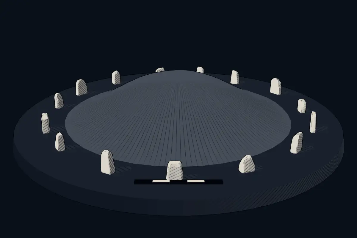
The reconstruction is ours, not a survey: it shows what a monument of this type looks like, at the size the record gives for this one.
Photographs
6 photographs, each with its author and licence
More photographs


Lore
Evidence & Lore
What the sources actually support — and, kept apart, what has been claimed.
What the evidence supports
Dates
Est. 3500–500 BCEHow this date was established: Type comparisonTypical range for megalithic mounds in Germany; this site has not been dated itself. German barrows ( Hugelgraber) run from the Neolithic (construction in central and south-west Germany c. 3500 BC and northern and central Germany c. 3400 BC) to the Late Bronze and Iron Age.Source for this date
Where it stands
Germany
The pin marks the monument itself — its exact point.
- Coordinates
- 54°11′15″ N, 10°01′03″ EFor a GPS or map app: 54.18740, 10.01750
Access is as our sources describe it; we have not visited the site to check.
Nearby
The closest sites in the Atlas, by straight line.
- DolmenGroßsteingräber bei Grevenkrug3500–2800 BCE
- MegalithLangbett Grevenkrug3500–2500 BCE
- DolmenDolmen von Langwedel3500–2800 BCE
- Megalithic tombDolmen Seedorf3500–2800 BCE
- Megalithic tombEisendorf 1 megalithic tomb3500–2800 BCE
- Megalithic tombEisendorf 2 megalithic tomb3500–2800 BCE
- DolmenGräberfeld von Flintbek3500–2800 BCE
 Großsteingrab Mielkendorf3500–2800 BCE

Sources
Every record behind this page, with the link it came from.
2 sources behind this page
- 01Wikidata Q902380wikidata.org
- 02Source for this dateen.wikipedia.org
Image files
- Brautberg-Bordesholm.jpgN-Lange.de . Original uploader was N-Lange.de at German WikipediaCC BY-SA 3.0
- Brautberg Denkmalschild u Treppenstufen IMG 7574.jpgSumpfolchCC0
- Brautberg oben Sitzbank IMG 7571.jpgSumpfolchCC0
- Bordesholm - Brautberg.jpgGenet at de.wikipediaCC BY-SA 3.0
- Bordesholm - Brautberg - Vier Steine.jpgGenet at de.wikipediaCC BY-SA 3.0
- Bordesholm - Brautberg - Schalenstein.jpgGenet at de.wikipediaCC BY-SA 3.0
Report a correctionWrong date, name, photograph or source? Tell us and it will be put right.
Around this place
The ten nearest sites, by compass
- Großsteingräber bei Grevenkrug4.2 km N
- Langbett Grevenkrug4.2 km N
- Dolmen von Langwedel6.3 km NW
- Dolmen Seedorf7.7 km W
- Eisendorf 1 megalithic tomb8.9 km W
- Eisendorf 2 megalithic tomb9.0 km W
- Gräberfeld von Flintbek9.2 km NE
- Großsteingrab Mielkendorf10 km N
- Steingrab Mielkendorf10 km N
- Großsteingräber bei Deutsch-Nienhof11 km NW
Credit
Text, licence and sources
Text from the Wikipedia article "Brautberg" (German), licensed CC BY-SA 4.0; authors are listed in the page history. Reused under CC BY-SA 4.0. Read on Wikipedia · Edit history and authors
- Wikipedia (German): BrautbergCC BY-SA 4.0
- Wikidata Q902380CC0